Until Proven Safe

[Image: Dressed in 21st-century personal protective equipment (PPE), I am standing next to Dr. Luigi Bertinato, wearing period plague doctor gear from the time of the Black Death, inside the library of the Querini Stampalia, Venice. Photo by Nicola Twilley.]

Long-time readers of this blog will hardly be surprised to hear of my interest in quarantine, a topic I’ve been posting and lecturing about since at least 2009. The Landscapes of Quarantine exhibition at Storefront for Art and Architecture, curated with Nicola Twilley back in 2010, was the beginning of a much larger project that we eventually returned to, several years ago, for a book on the subject.

Originally titled—and sold to our editor as—The Coming Quarantine, we had to change the book’s name when COVID-19 hit. Surreally, we ended up finishing a book about quarantine while in a state of medical detention—indeed, at one point late last spring, more than half the world’s human population was in some state of quarantine or lockdown.

Our book’s hypothesis and prediction was, in fact, that we would all be quarantining more in the future, not less, relying on this seemingly medieval tool of spatial isolation to protect ourselves from emerging diseases for which we had no natural immunity, no available vaccination, and no cure. Why quarantine? It is the use of space and time to overcome uncertainty, creating a buffer between ourselves and a potentially infectious other until that suspected threat can be proven safe.

[Image: An arch inside the abandoned lazaretto, or quarantine hospital, on Manoel Island, Malta; photo by Geoff Manaugh.]

Until Proven Safe: The History and Future of Quarantine—the book we have been traveling for, reporting, and working on since summer 2016—finally comes out tomorrow, July 20th. I am unbelievably excited about this book, for millions of reasons. On one level, it combines so many of the long-running interests here on this blog, from quarantine itself to architectural ruins, mythology & horror, science fiction, space exploration, the Army Corps of Engineers, agricultural landscapes, strange animal diseases, extraordinary engineering controls, the ethical dangers of smart homes, even nuclear waste.

Having posted little to nothing about this book over the past few years—indeed, having posted almost nothing about COVID-19—it’s also immensely relieving to finally release this thing into the world.

[Image: Inside the lazaretto at Ancona, Italy; photo by Geoff Manaugh.]

Some highlights that I think would appeal to BLDGBLOG readers include Nicky’s and my travelogue around the Adriatic and Mediterranean seas, exploring ruined lazarettos in the footsteps of 18th-century British prison reformer—and quarantine critic—John Howard. We climbed locked fences into ruins on Malta, took a night ship across the Adriatic to disembark near the extraordinary pentagonal lazaretto in Ancona, and we got to tour the then-closed Lazzaretto Nuovo in Venice, Italy, with the local man intent on preserving it. (His original plan, he admitted, was to turn the island into a martial arts dojo.)

In other parts of the book, we sit down with the head of the Disinfected Mail Study Circle, based in North London. That group collects rare pieces of mail sent to and from sites of quarantine; like characters in a Thomas Pynchon novel, their postal archaeology has revealed previously forgotten outbreaks and odd geopolitical details about the formation of international borders.

We also visited the first federal quarantine facility, then under construction, in the United States in more than a hundred years, mere months before COVID-19, and we spoke with the former head of the Army Corps of Engineers about plans for retrofitting hotels, convention centers, and stadiums, as well as the prospect of pop-up home quarantine kits in the near-future. We visited the Ebola high-level isolation unit at the Royal Free Hospital in London—where Nicky climbed inside.

[Image: Nicola Twilley inside the high-level isolation unit’s Trexler Ebola system; photo by Geoff Manaugh.]

In the latter half of the book—primarily dedicated to nonhuman quarantine, or quarantine applied to the plant, animal, and mineral kingdoms, capped off by a look at “planetary protection” and the risk of alien microbes—we were able to see a brand-new high-level animal-disease research lab in the middle of U.S. cattle country. This is the nation’s replacement for the aging facility on Plum Island, subject of countless conspiracy theories.

Elsewhere, we went deep into WIPP—the Waste Isolation Pilot Plant—outside Carlsbad, New Mexico, to see nuclear waste being buried and isolated from the Earth’s biosphere for a federally-mandated time periods of at least 100,000 years. We got to see the Apollo moon rocks and learn about the history of lunar quarantine, and even sat down with two of NASA’s Planetary Protection Officers—and their counterpart at the European Space Agency—to discuss the quarantine challenge of bringing Mars geology back to Earth. Along the way, we got to see Perseverance, the Mars rover, before its long (and successful) journey to Mars.

[Image: Walking inside the Waste Isolation Pilot Plant, a salt mine 2,150 feet below the surface of the Earth, where the United States is permanently burying nuclear waste; photo by Nicola Twilley.]

Reporting the book also led us to a series of high-level pandemic simulations over the course of several years—all the way up to the incredible experience of sitting in on a simulation in October 2019, the premise of which was a global outbreak of a novel coronavirus. As we sat there, listening to government figures role-play what they would do, the very earliest cases of COVID-19 were likely circulating in China, undetected.

We also look at the limits of mathematical modeling, the encroachment of algorithms and Big Data into the future of quarantine, and the dystopian potential of involuntary medical isolation automatically enforced by today’s smart homes.

And, through all of that, one of our biggest coups, I think, was recording hours of interviews with the head of the CDC’s division of global migration and quarantine, visiting him in his office at the CDC and recording anguished, on-the-record discussions during the Trump Administration about the nation’s COVID-19 response.

A great way to get a flavor of the book would be to check out excerpts published in WIRED and The Guardian—and, tomorrow morning, The Atlantic—or to listen to the Gastropod episode we did on quarantine, agriculture, and threats to the world’s chocolate supply.

[Image: Until Proven Safe, with a cover design by Alex Merto.]

If you’re tempted, you can order a copy from Bookshop, Indiebound, Amazon, Barnes & Noble, or your local independent bookshop, etc. etc.

Note: This post contains affiliate links to Amazon and Bookshop from which I might draw a small percentage of any book sales.

Angeleno Redux

[Image: Underground tennis courts in a limestone mine and refrigeration complex in Missouri].

It’s been a long month, but my wife and I have packed up and left New York, endlessly bubble-wrapping things while watching Midnight Run, Collateral, Chinatown, and other L.A.-themed movies on a laptop in an empty room, to head west again to Los Angeles, where we finally arrived today.

We visited the Cahokia Mounds, a heavily eroded indigenous North American city that, at its height, was larger than London, part of a Wisconsin-to-Louisiana band of settlements sculpted from mud and clay. The remains of history are not necessarily built with stone and timber—let alone steel and glass—but might exist in the form of oddly sloped hillsides or gardens long ago left untended.

[Image: Hiking around Cahokia Mounds].

Along the way, we managed to see the total eclipse in Missouri, sitting on a picnic blanket in a park south of St. Louis, people around us crying, yelling “Look at that!,” laughing, cheering like it was a football game, a day before driving further southwest to explore food-refrigeration caverns in active limestone mines for Nicky’s book.

That’s where we stumbled on the tennis courts pictured at the top of this post, at least seventy feet below ground, complete with a wall of framed photos showing previous champions of the underworld leagues, as we drove around for an hour or two through genuinely huge subterranean naves and corridors, with not-yet-renovated sections of the mine—millions of square feet—hidden behind titanic yellow curtains.

[Image: Behind these curtains are millions—of square-feet of void].

We listened to S-Town. We had breakfast in Oklahoma City. We made it to New Mexico to hike up a 10,000-year-old volcano with an ice cave frozen at a permanent 31º in one of its half-collapsed lava tubes where we met another couple who had driven up from Arizona “to get out of the heat.”

[Image: Bandera Volcano, New Mexico].

We then spent three days in Flagstaff to sleep, watch GLOW, and inadvertently off-road on our quest to do some hiking, up fire roads, up canyons behind Sedona, up hills in the rain, looking north toward the cinder cones of dead volcanoes that we visited a few years ago for Venue, where, in the 1960s, NASA recreated the surface of the moon using timed explosions.

[Image: Hiking outside Flagstaff].

In any case, we’re now back in Los Angeles, the city that most perversely fulfills whatever strange promises this country offers, and we’ll be here for the long haul. In fact, there’s no real reason to post this, other than: why not? But, if you live in L.A., or anywhere in California, perhaps we’ll cross paths soon.

Under the Dome

[Image: Courtesy U.S. Department of the Interior Bureau of Ocean Energy Management (BOEM)].

A gigapixel bathymetric map of the Gulf of Mexico’s seabed has been released, and it’s incredible. The newly achieved level of detail is almost hard to believe.

[Images: Courtesy U.S. Department of the Interior Bureau of Ocean Energy Management (BOEM)].

The geology of the region is “driven not by plate tectonics but by the movement of subsurface bodies of salt,” Eos reported last week. “Salt deposits, a remnant of an ocean that existed some 200 million years ago, behave in a certain way when overlain by heavy sediments. They compact, deform, squeeze into cracks, and balloon into overlying material.”

This means that the bottom of the Gulf of Mexico “is a terrain continually in flux.”

How the salt got there is the subject of a long but fascinating description at Eos.

It is hypothesized that the salt precipitated out of hypersaline seawater when Africa and South America pulled away from North America during the Triassic and Jurassic, some 200 million years ago. The [Gulf of Mexico] was initially an enclosed, restricted basin into which seawater infiltrated and then evaporated in an arid climate, causing the hypersalinity (similar to what happened in the Great Salt Lake in Utah and the Dead Sea between Israel and Jordan).

Salt filled the basin to depths of thousands of meters until it was opened to the ancestral Atlantic Ocean and consequently regained open marine circulation and normal salinities. As geologic time progressed, river deltas and marine microfossils deposited thousands more meters of sediments into the basin, atop the thick layer of salt.

The salt, subjected to the immense pressure and heat of being buried kilometers deep, deformed like putty over time, oozing upward toward the seafloor. The moving salt fractured and faulted the overlying brittle sediments, in turn creating natural pathways for deep oil and gas to seep upward through the cracks and form reservoirs within shallower geologic layers.

These otherwise invisible landscape features “oozing upward” from beneath the seabed are known as salt domes, and they are not only found at the bottom of the Gulf of Mexico.

[Image: Avery Island, Louisiana, archived by the U.S. Library of Congress].

The black and white photos you see here are from a salt mine on Avery Island, Louisiana, archived by the U.S. Library of Congress. The photos date back as far as 1900, and they’re gorgeous.

[Image: Avery Island, Louisiana, archived by the U.S. Library of Congress].

This is what it looks like inside those salt domes, you might way, once industrially equipped human beings have carved wormlike topological spaces into the deformed, ballooning salt deposits of the region.

[Image: Avery Island, Louisiana, archived by the U.S. Library of Congress].

Obviously, the Gulf of Mexico is not the only salt-rich region of the United States; there is a huge salt mine beneath the city of Detroit, for example, and the nation’s first nuclear waste repository, the Waste Isolation Pilot Plant, or WIPP—which my wife and I had the surreal pleasure of visiting in person back in 2012—is dug into a huge underground salt deposit near the New Mexico/Texas border.

[Image: Inside WIPP; photo by Nicola Twilley].

Nonetheless, the Louisiana/Gulf of Mexico salt dome region has lent itself to some particularly provocative landscape myths.

You might recall, for example, the story of Lake Peigneur, an inland body of water that was almost entirely drained from below when a Texaco drilling rig accidentally punctured a salt dome beneath the lake.

This led to the sight of a rapid, Edgar Allan Poe-like maelström of swirling water disappearing into the abyss, pulling no fewer than eleven barges into the terrestrial deep.

[Image: Avery Island, Louisiana, archived by the U.S. Library of Congress].

But there is also the story of Bayou Corne, one of my favorite conspiracy theories of all time.

[Images: Avery Island, Louisiana, archived by the U.S. Library of Congress].

As the New York Times reported back in 2013, “in the predawn blackness of Aug. 3, 2012, the earth opened up—a voracious maw 325 feet across and hundreds of feet deep, swallowing 100-foot trees, guzzling water from adjacent swamps and belching methane from a thousand feet or more beneath the surface.”

One resident of the area is quoted as saying, “I think I caught a glimpse of hell in it.”

More than a year after it appeared, the Bayou Corne sinkhole is about 25 acres and still growing, almost as big as 20 football fields, lazily biting off chunks of forest and creeping hungrily toward an earthen berm built to contain its oily waters. It has its own Facebook page and its own groupies, conspiracy theorists who insist the pit is somehow linked to the Gulf of Mexico 50 miles south and the earthquake-prone New Madrid fault 450 miles north. It has confounded geologists who have struggled to explain this scar in the earth.

To oversimplify things, the overall theory—that is, the conspiratorial part of all this—is that the entire landscape of the Gulf region is on the verge of subterranean dissolution. The very salt deposits so beautifully mapped by the Bureau of Ocean Energy Management are all lined up for eventual flooding.

As this vast underground landscape of salt dissolves, everything from east Texas to west Florida will be sucked down into the abyss.

[Image: Avery Island, Louisiana, archived by the U.S. Library of Congress].

It’s unlikely that this will happen, I should say. You can sleep well at night.

In the meantime, the sorts of salt-mining operations depicted here in these photographs have carved their worming, subterranean way into the warped terrains of salt that dynamically ooze their way up to the surface from geological prehistory.

[Image: Avery Island, Louisiana, archived by the U.S. Library of Congress].

Be sure to check out the full gigapixel BOEM map, and the helpful write-up over at Eos is worth a read, as well. As for the Bayou Corne conspiracy—I suppose we’ll just have to wait.

(Bathymetric maps spotted via Chris Rowan; salt mine photos originally spotted a very long time ago via Attila Nagy).

Landscape Futures Super-Trip

I’m heading off soon on a road trip with Nicola Twilley, from Edible Geography, to visit some incredible sites (and sights) around the desert southwest, visiting places where architecture, astronomy, and the planetary sciences, to varying degrees, overlap.

[Image: The Very Large Array].

This will be an amazing trip! Our stops include the “world’s largest collection of optical telescopes,” including the great hypotenuse of the McMath-Pierce Solar Telescope, outside Tucson; the Very Large Array in west-central New Mexico; the Controlled Environment Agriculture Center at the University of Arizona, aka the “lunar greenhouse,” where “researchers are demonstrating that plants from Earth could be grown without soil on the moon or Mars, setting the table for astronauts who would find potatoes, peanuts, tomatoes, peppers and other vegetables awaiting their arrival”; the surreal encrustations of the Salton Sea, a site that, in the words of Kim Stringfellow, “provides an excellent example of the the growing overlap of humanmade and natural environments, and as such highlights the complex issues facing the management of ecosystems today”; the Fred Lawrence Whipple Observatory, with its automated scanning systems used for “robotic searches for variable stars and exoplanets” in the night sky, and its gamma-ray reflectors and “blazar lightcurves” flashing nearby; the Grand Canyon; Red Rocks, outside Sedona; the hermetic interiorities of Biosphere 2; White Sands National Monument and the Trinity Site marker, with its so-called bomb glass; the giant aircraft “boneyard” at the Pima Air & Space Museum; and, last but not least, the unbelievably fascinating Lunar Laser-ranging Experiment at Apache Point, New Mexico, where they shoot lasers at prismatic retroreflectors on the moon, testing theories of gravitation, arriving there by way of the nearby Dunn Solar Telescope.

[Image: The “Electric Aurora,” from Specimens of Unnatural History, by Liam Young].

The ulterior motive behind the trip—a kind of text-based, desert variation on Christian Houge’s study of instrumentation complexes in the Arctic—is to finish up my curator’s essay for the forthcoming Landscape Futures book.

That book documents a forthcoming exhibition at the Nevada Museum of Art called Landscape Futures: Instruments, Devices and Architectural Inventions, featuring work by David Benjamin & Soo-in Yang (The Living), Mark Smout & Laura Allen (Smout Allen), David Gissen, Mason White & Lola Sheppard (Lateral Office), Chris Woebken, and Liam Young.

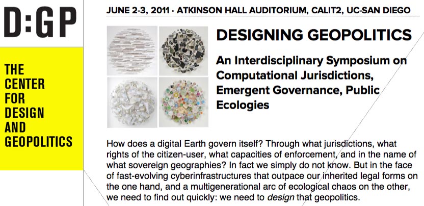
Finally, Nicola and I will fall out of the car in a state of semi-delirium in La Jolla, California, where I’ll be presenting at a 2-day symposium on Designing Geopolitics, “an interdisciplinary symposium on computational jurisdictions, emergent governance, public ecologies,” organized by Benjamin Bratton, Daniel Rehn, and Tara Zepel.

That will be free and open to the public, for anyone in the San Diego area who might want to stop by, and it will also be streamed online in its entirety; the full schedule is available at the Designing Geopolitics site.

(Earlier on BLDGBLOG: Landscape Futures Super-Workshop, Landscape Futures Super-Dialogue, and Landscape Futures Super-Media).