Ten years ago, this would have been a speculative design project by SaschaPohflepp: “hyper-accumulating” plants are being used to concentrate, and thus “mine,” valuable metals from soil.
[Image: Nickel-rich sap; photo by Antony van der Ent, courtesy New York Times.]
“With roots that act practically like magnets, these organisms—about 700 are known—flourish in metal-rich soils that make hundreds of thousands of other plant species flee or die,” the New York Times reported last week. “Slicing open one of these trees or running the leaves of its bush cousin through a peanut press produces a sap that oozes a neon blue-green. This ‘juice’ is actually one-quarter nickel, far more concentrated than the ore feeding the world’s nickel smelters.”
A while back, I went on a road-trip with Edible Geography to visit some maple syrup farms north of where we lived at the time, in New York City. The woods all around us were tubed together in a huge, tree-spanning network—“forest hydraulics,” as Edible Geography phrased it at the time—as the trees’ valuable liquid slowly flowed toward a pumping station in the center of the forest.
It was part labyrinth, part spiderweb, a kind of semi-automated tree-machine at odds with the image of nature with which most maple syrup is sold.
[Images: Photos by BLDGBLOG.]
Imagining a similar landscape, but one designed as a kind of botanical mine—a forest accumulator, metallurgical druidry—is incredible.
And it’s not even a modern idea, as the New York Times points out. For all its apparent, 21st-century sci-fi, the idea of harvesting metal from plants is at least half a millennium old: “The father of modern mineral smelting, Georgius Agricola, saw this potential 500 years ago. He smelted plants in his free time. If you knew what to look for in a leaf, he wrote in the 16th century, you could deduce which metals lay in the ground below.”
This brings to mind an older post here about detection landscapes, or landscapes—yards, meadows, gardens, forests—deliberately planted with species that can indicate what is in the soil beneath them.
In the specific case of that post, this had archaeological value, allowing researchers to find abandoned Viking settlements in Greenland based on slight chemical changes that have affected which plants are able to thrive. Certain patches of flower, for example, act as archaeological indicator species, marking the locations of lost settlements.
In any case, my point is simply that vegetation can be read, or treated as a sign to be interpreted, whether by indicating the presence of archaeological ruins or by revealing the potential market-value of a site’s subterranean metal content.
Indeed, we read, “This vegetation could be the world’s most efficient, solar-powered mineral smelters,” with “the additional value of enabling areas with toxic soils to be made productive. Smallholding farmers could grow on metal-rich soils, and mining companies might use these plants to clean up their former mines and waste and even collect some revenue.” That is, you could filter and clean contaminated soils by drawing heavy-metal pollutants out of the ground, producing saps that are later harvested.
Fast-forward ten years: it’s 2030 and landscape architecture studios around the world are filled with speculative metal-harvesting plant designs—contaminated landscapes laced with gardens of hardy, sap-producing trees—even as industrial behemoths, like Rio Tinto and Barrick Gold, are breeding proprietary tree species in top-secret labs, genetically modifying them to maximize metal uptake.
Weird saps accumulate in iridescent lagoons. Autumn leaves glint, literally metallic, in the sun. Tiny metal capillaries weave up the trunks of black-wooded trees, in filigrees of gold and silver. The occasional forest fire smells not of smoke, but of copper and tin. Reclaimed timber, with knots and veins partially metallized, is used as luxury flooring in suburban homes.
Picher is something like the Centralia of Oklahoma, where Centralia is the town in Pennsylvania that has been slowly abandoned over a generation due to coal mine fires burning away beneath its streets. In Picher, however, it’s not coal smoke but collapsing lead mines that have led to a forced buy-out and evacuation, a haunting process tragically assisted in 2008 when a massive tornado hit town, ripping apart many of its remaining houses and buildings.
Today, Picher is not entirely empty, but it has become more of a macabre curiosity on the state’s border with Kansas, its quiet streets overgrown and surrounded by looming piles of “chat,” or mine tailings, alpine forms that give the landscape its toxic profile.
[Image: Picher, surrounded by its toxic artificial landforms; via Google Maps].
The Washington Post visited the town back in 2007. “Signs of Picher’s impending death are everywhere,” they wrote at the time. “Many stores along Highway 69, the town’s main street, are empty, their windows coated with a layer of grime, virtually concealing the abandoned merchandise still on display. Trucks traveling along the highway are diverted around Picher for fear that the hollowed-out mines under the town would cause the streets to collapse under the weight of big rigs.” Note that this was written a year before the tornado.
Oklahoma native Allison Meier has written up Todd Stewart’s exhibition, including a longer, horrific backstory to the town, with red rivers of acidic water “belching” up from abandoned mines, kids playing in sandboxes of powdered lead, and horses poisoned by the runoff.
“The poisoning of Picher may seem like a local story,” Meier writes, “and, indeed, remains little known on a national level. Yet the state of Oklahoma continues to practice environmentally hazardous extraction, including fracking for gas. And in the United States, the promotion of toxic industry—even if it results in the destruction of the very place it is supporting—endures.”
Here’s a link to the actual exhibition, and you can buy a copy of Todd Stewart’s book here. Wired also visited Picher a few years back, if you’re looking for more.
[Image: Courtesy U.S. Department of the Interior Bureau of Ocean Energy Management (BOEM)].
A gigapixel bathymetric map of the Gulf of Mexico’s seabed has been released, and it’s incredible. The newly achieved level of detail is almost hard to believe.
[Images: Courtesy U.S. Department of the Interior Bureau of Ocean Energy Management (BOEM)].
The geology of the region is “driven not by plate tectonics but by the movement of subsurface bodies of salt,” Eos reported last week. “Salt deposits, a remnant of an ocean that existed some 200 million years ago, behave in a certain way when overlain by heavy sediments. They compact, deform, squeeze into cracks, and balloon into overlying material.”
This means that the bottom of the Gulf of Mexico “is a terrain continually in flux.”
How the salt got there is the subject of a long but fascinating description at Eos.
It is hypothesized that the salt precipitated out of hypersaline seawater when Africa and South America pulled away from North America during the Triassic and Jurassic, some 200 million years ago. The [Gulf of Mexico] was initially an enclosed, restricted basin into which seawater infiltrated and then evaporated in an arid climate, causing the hypersalinity (similar to what happened in the Great Salt Lake in Utah and the Dead Sea between Israel and Jordan).
Salt filled the basin to depths of thousands of meters until it was opened to the ancestral Atlantic Ocean and consequently regained open marine circulation and normal salinities. As geologic time progressed, river deltas and marine microfossils deposited thousands more meters of sediments into the basin, atop the thick layer of salt.
The salt, subjected to the immense pressure and heat of being buried kilometers deep, deformed like putty over time, oozing upward toward the seafloor. The moving salt fractured and faulted the overlying brittle sediments, in turn creating natural pathways for deep oil and gas to seep upward through the cracks and form reservoirs within shallower geologic layers.
These otherwise invisible landscape features “oozing upward” from beneath the seabed are known as salt domes, and they are not only found at the bottom of the Gulf of Mexico.
The black and white photos you see here are from a salt mine on Avery Island, Louisiana, archived by the U.S. Library of Congress. The photos date back as far as 1900, and they’re gorgeous.
This is what it looks like inside those salt domes, you might way, once industrially equipped human beings have carved wormlike topological spaces into the deformed, ballooning salt deposits of the region.
Obviously, the Gulf of Mexico is not the only salt-rich region of the United States; there is a huge salt mine beneath the city of Detroit, for example, and the nation’s first nuclear waste repository, the Waste Isolation Pilot Plant, or WIPP—which my wife and I had the surreal pleasure of visiting in person back in 2012—is dug into a huge underground salt deposit near the New Mexico/Texas border.
Nonetheless, the Louisiana/Gulf of Mexico salt dome region has lent itself to some particularly provocative landscape myths.
You might recall, for example, the story of Lake Peigneur, an inland body of water that was almost entirely drained from below when a Texaco drilling rig accidentally punctured a salt dome beneath the lake.
This led to the sight of a rapid, Edgar Allan Poe-like maelström of swirling water disappearing into the abyss, pulling no fewer than eleven barges into the terrestrial deep.
As the New York Times reported back in 2013, “in the predawn blackness of Aug. 3, 2012, the earth opened up—a voracious maw 325 feet across and hundreds of feet deep, swallowing 100-foot trees, guzzling water from adjacent swamps and belching methane from a thousand feet or more beneath the surface.”
One resident of the area is quoted as saying, “I think I caught a glimpse of hell in it.”
More than a year after it appeared, the Bayou Corne sinkhole is about 25 acres and still growing, almost as big as 20 football fields, lazily biting off chunks of forest and creeping hungrily toward an earthen berm built to contain its oily waters. It has its own Facebook page and its own groupies, conspiracy theorists who insist the pit is somehow linked to the Gulf of Mexico 50 miles south and the earthquake-prone New Madrid fault 450 miles north. It has confounded geologists who have struggled to explain this scar in the earth.
To oversimplify things, the overall theory—that is, the conspiratorial part of all this—is that the entire landscape of the Gulf region is on the verge of subterranean dissolution. The very salt deposits so beautifully mapped by the Bureau of Ocean Energy Management are all lined up for eventual flooding.
As this vast underground landscape of salt dissolves, everything from east Texas to west Florida will be sucked down into the abyss.
It’s unlikely that this will happen, I should say. You can sleep well at night.
In the meantime, the sorts of salt-mining operations depicted here in these photographs have carved their worming, subterranean way into the warped terrains of salt that dynamically ooze their way up to the surface from geological prehistory.
Be sure to check out the full gigapixel BOEM map, and the helpful write-up over at Eos is worth a read, as well. As for the Bayou Corne conspiracy—I suppose we’ll just have to wait.
(Bathymetric maps spotted via Chris Rowan; salt mine photos originally spotted a very long time ago via Attila Nagy).
[Image: Drone footage of a Cornwall garden sinkhole, via the BBC].
One of the peculiar pleasures of reading Subterranea, a magazine published by Subterranea Britannica, is catching up on British sinkhole news.
In more or less every issue, there will be tales of such things as “a mysterious collapse in a garden behind a 19th-century house,” that turns out to be a shaft leading down into a forgotten sand mine, or of “abandoned chalk mine sites” heavily eroding in winter rain storms, “resulting in roof-falls.”
“As most chalk mines are at relatively shallow depth,” Subterranea reports, “these roof-falls migrate upwards to break [the] surface as ‘crown holes’ or craters, which in the said winter [of 2013/2014] have been appearing in lawns and driveways, and even under houses, newly built in chalk districts.”
The earth deceptively hollow, the landscape around you actually a ceiling for spaces beneath.
Worryingly, many of these mines and underground quarries are difficult, if not impossible, to locate, as insufficient regulation combined with shabby documentation practices mean that there could be abandoned underground workings you might never be aware of hiding beneath your own property—until next winter’s rains kick in, that is, or the next, when you can look forward to staring out at the grass and shrubbery, with growing angst, waiting for sinkholes to appear. Rain becomes a kind of cave-finding technology.
Even in the heart of London, the underworld beckons. Last Spring, Subterranea reminds us, “a woman and her shopping trolley rather suddenly disappeared into a four metres deep hole in North End Road, Fulham.” The culprit? It “appears to have been a disused under-street coal cellar.”
Perhaps the most incredible recent example, however, comes from the town of Scorrier, in Cornwall.
There, a “deep mine shaft has appeared” beneath the patio of a house in the process of being prepped for sale. “The shaft drops approximately 300 feet deep to water but could be four or five times deeper [!] below that,” Subterranea reports. It “is a remnant of Cornwall’s tin mining industry in the 18th century.”
It is a straight vertical shaft, more like a rectangular well, yawning open behind the house.
And there are many more of these mines and quarries, still waiting to be discovered: “As mines closed,” we read, “many [mining companies] put very large blocks of timber, often old railway sleepers, across shafts and backfilled them, thinking this would be safe. Gradually all evidence of the engine houses and covered shafts disappeared from view and memory and in the past builders assumed there was nothing there. Had they consulted old maps they would have known about the shaft. The timbers rotted over the years and collapses like this often happen after long periods of rain, which they have had in this area.”
There’s something both uncanny and compelling about the idea that, with seasons of increased rainfall due to climate change, the nation’s mining industry might stage an unsettling reappearance, bursting open in subterranean splendor to swallow the surface world whole.
Think of it as an industrial-historical variation on the El Niño rains in Los Angeles—where huge storms were suspected of “unearthing more skeletal human remains” in the parched hills outside the city—only here given the horror movie ambience of murderous voids opening up beneath houses, making their abyssal presence felt after long winter nights of darkness and endless rain.
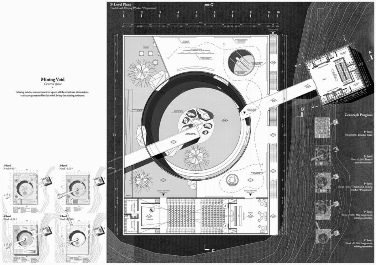
Here’s another project from the RIBA President’s Medals, this one by Alexis Quinteros Salazar, a student at the University of Chile in Santiago.
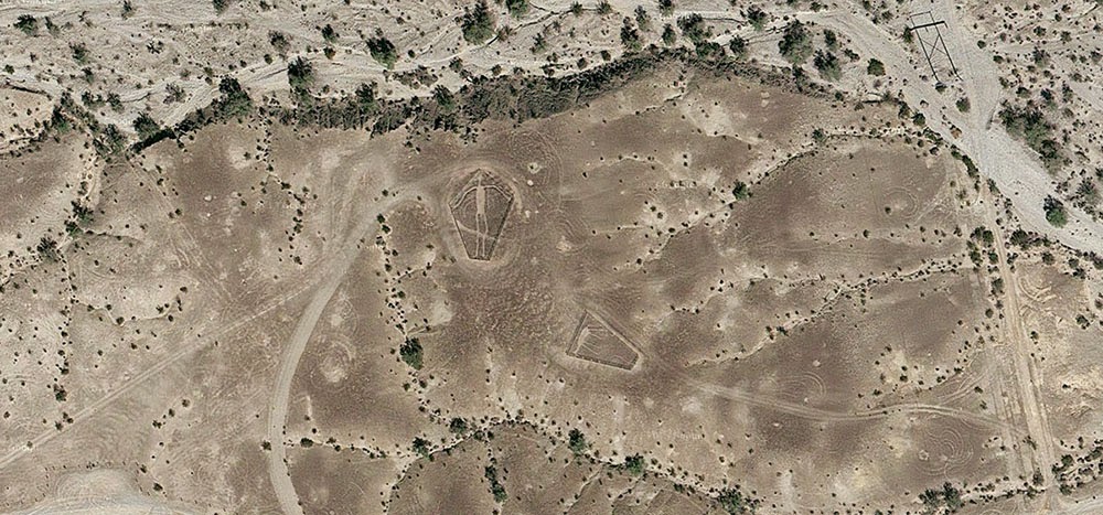
Called “Mining Cenotaph,” it imagines an “occupation” of the tailings piles that have become a toxic urban landmark and a spatial reminder of the region’s economic exploitation.
A museum would be carved into the tailings; in Salazar’s words, this would be a “building that captures the history and symbolism behind mining, enhancing and revitalizing a memory that is currently disaggregated and ignored and has a very high touristic potential.”
In an architectural context such as this, the use of the word “cenotaph” is a pretty clear reference to Étienne-Louis Boullée’s classic speculative project, the “Cenotaph for Newton.” Over multiple generations, that has become something of a prime mover in the history of experimental architectural design.
Punctured walls and ceilings bring light into the interior—
—while the roof is a recreational space for visitors.
Of course, there are a lot of unanswered questions here—including the control of aerosol pollution from the tailings pile itself and that pile’s own long-term structural stability—but the poetic gesture of a public museum grafted into a pile of waste material is worth commending.
The detail I might like this most is where the structure becomes a kind of inversion of Boullée’s dome, which was pierced to make its huge interior space appear illuminated from above by constellations. Here, instead, it is the perforations in the the rooftop that would glow upward from below, as if in resonance with the night skies high above.
Salazar’s project brings to mind a few other proposals seen here over the years, including the extraordinary “Memorial to a Buried Village” by Bo Li and Ge Men, as well as Brandon Mosley’s “Mine Plug” (which actually took its name retroactively from that BLDGBLOG post).
After reading an article about the “Blythe geoglyphs”—huge, 1,000-year old images carved into the California desert north of Blythe, near the border with Arizona—I got to looking around on Google Maps more or less at random and found what looked like a ghost town in the middle of nowhere, close to an old mine.
Turns out, it was the abandoned industrial settlement of Midland, California—and it’s been empty for nearly half a century, deliberately burned to the ground in 1966 when the nearby mine was closed.
What’s so interesting about this place—aside from the exposed concrete foundation pads now reused as platforms for RVs, or the empty streets forming an altogether different kind of geoglyph, or even the obvious ease with which one can get there, simply following the aptly named Midland Road northeast from Blythe—is the fact that the town was built for workers at the gypsum mine, and that the gypsum extracted from the ground in Midland was then used as artificial snow in many Hollywood productions.
As the L.A. Times reported back in 1970—warning its readers, “Don’t Go To Midland—It’s Gone”—the town served as the mineral origin for Hollywood’s simulated weather effects.
“Midland was started in 1925 as a tent city,” the paper explained, “with miners in the middle of the Mojave Desert digging gypsum out of the Little Marias to meet the demands of movie studios. All the winter scenes during the golden age of Hollywood were filmed with ‘snowflakes’ from Midland.”
[Image: The abandoned streets of Midland, former origin of Hollywood’s artificial snow; photo via CLUI].
Like some strange, artificial winter being mined from the earth and scattered all over the dreams of cinemagoers around the world, Midland’s mineral snow had all the right qualities without any of the perishability or cold.
See, for example, this patent for artificial snow, filed in 1927 and approved in 1930, in which it is explained how gypsum can be dissolved by a specific acid mix to produce light, fluffy flakes perfect for the purposes of winter simulation. Easy to produce, with no risk of melting.
I’ve long been fascinated by the artificial snow industry—the notion of an industrially controlled climate-on-demand, spraying out snowflakes as if from a 3D printer, is just amazing to me—as well as with the unearthly world of mines, caves, and all things underground, but I had not really ever imagined that these interests might somehow come together someday, wherein fake glaciers and peaceful drifts of pure white snow were actually something scraped out of the planet by the extraction industry.
As if suggesting the plot of a deranged, Dr. Seussian children’s book, the idea that winter is something we pull from a mine in the middle of the California desert and then scatter over the warm Mediterranean cities of the coast is perhaps all the evidence you need that life is always already more dreamlike than you had previously believed possible.
(Very vaguely related: See also BLDGBLOG’s earlier coverage of CaliforniaCity).
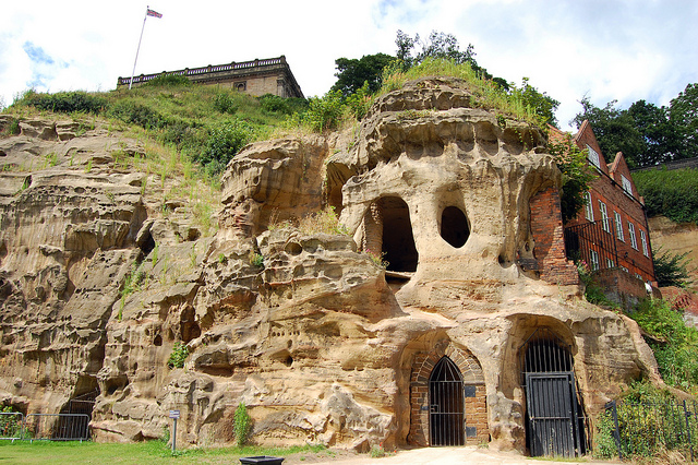
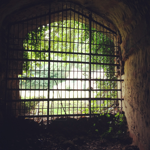
[Image: Cliffs and caves of Nottingham; photo by Nicola Twilley].
For severalyears now, I’ve admired from afar the ambitious laser-scanning subterranean archaeological project of the Nottingham Caves Survey.
Incredibly, there are more than 450 artificial caves excavated from the sandstone beneath the streets and buildings of Nottingham, England—including, legendarily, the old dungeon that once held Robin Hood—and not all of them are known even today, let alone mapped or studied. The city sits atop a labyrinth of human-carved spaces—some of them huge—and it will quite simply never be certain if archaeologists and historians have found them all.
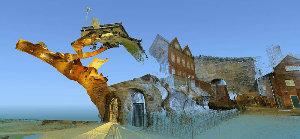
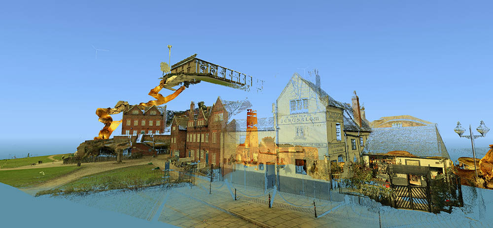
[Images: Laser scans from the Nottingham Caves Survey show Castle Rock and the Mortimer’s Hole tunnel, including, in the bottom image, the Trip to Jerusalem Pub where we met archaeologist David Strange-Walker; images like this imply an exhilarating and almost psychedelic portrait of the city as invisibly connected behind the scenes by an umbilical network of caves and tunnels. Scans courtesy of the Nottingham Caves Survey].
“Even back in Saxon times, Nottingham was known for its caves,” local historian Tony Waltham writes in his helpful guide Sandstone Caves of Nottingham, “though the great majority of those which survive today were cut much more recently.” From malt kilns to pub cellars, “gentlemen’s lounges” to jails, and wells to cisterns, these caves form an almost entirely privately-owned lacework of voids beneath the city.
[Image: Map of only the known caves in Nottingham, and only in Nottingham’s city center; map by Tony Waltham, from Sandstone Caves of Nottingham].
As Waltham explains, “Nottingham has so many caves quite simply because the physical properties of the bedrock sandstone are ideal for its excavation.” The sandstone “is easily excavated with only hand tools, yet will safely stand as an unsupported arch of low profile.”
In a sense, Nottingham is the Cappadocia of the British Isles.
The purpose of the Nottingham Caves Survey, as their website explains, is “to assess the archaeological importance of Nottingham’s caves. Some are currently scheduled monuments and are of great local and national importance. Some are pub cellars and may seem less vital to the history of the City.”
Others, I was soon to learn, have been bricked off, taken apart, filled in, or forgotten.
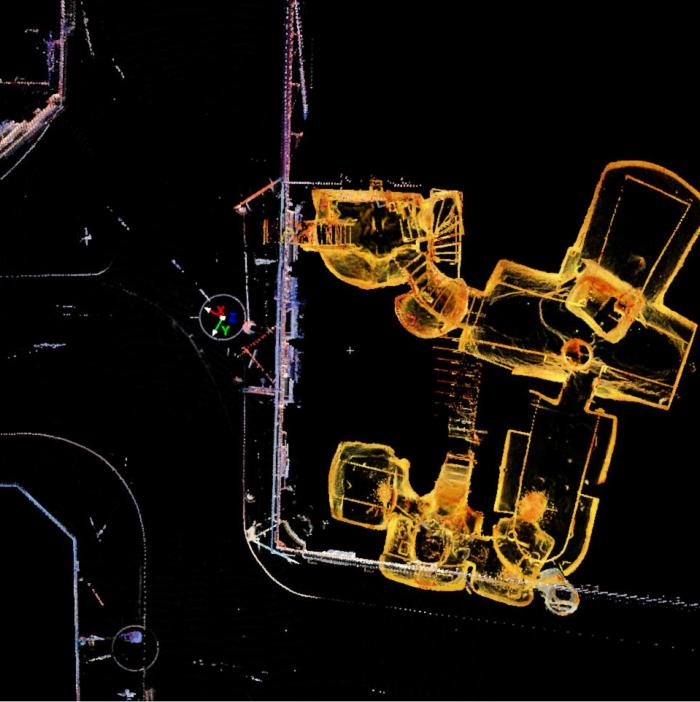
“All caves that can be physically accessed will be surveyed with a 3D laser scanner,” the Survey adds, “producing a full measured record of the caves in three dimensions. This ‘point cloud’ of millions of individual survey points can be cut and sliced into plans and sections, ‘flown through’ in short videos, and examined in great detail on the web.”
[Video: One of very many laser-scan animations from the Nottingham Caves Survey].
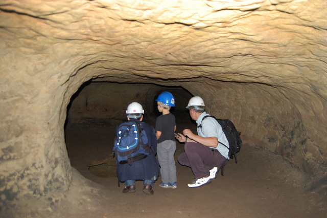
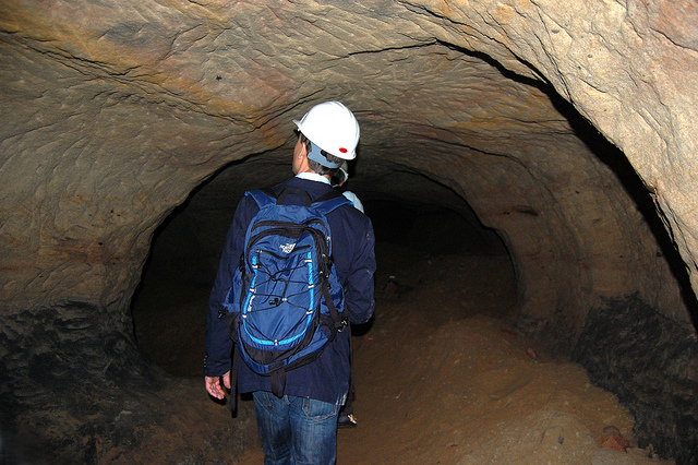
While over in England a few weeks ago, I got in touch with archaeologist David Strange-Walker, the project’s manager, and arranged for a visit up to Nottingham to learn more about the project. Best of all, David very generously organized an entire day’s worth of explorations, going down into many of the city’s underground spaces in person with David himself as our guide. Joining me on the trip north from London was Nicola Twilley of Edible Geography; architect Mark Smout of Smout Allen and co-author of the fantastic Pamphlet Architecture installment, Augmented Landscapes; and Mark’s young son, Ellis.
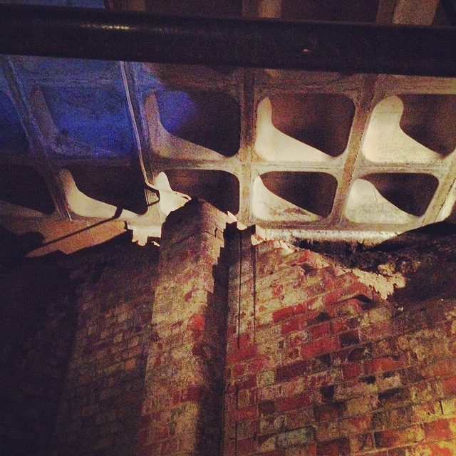
[Image: Artificially enlarged pores in the sandstone; photo by BLDGBLOG].
We met the very likable and energetic David—who was dressed for a full day of activity, complete with a well-weathered backpack that we’d later learn contained hard hats and floodlights for each of us—outside Nottingham’s Trip to Jerusalem pub.
Rather than kicking off our visit with a pint, however, we simply walked inside to see how the pub had been partially built—that is, expanded through deliberate excavation—into the sandstone cliffside.
The building is thus more like a facade wrapped around and disguising the artificial caves behind it; walking in past the bar, for instance, you soon notice ventilation shafts and strange half-stairways, curved walls and unpredictable acoustics, as the “network of caves” that actually constitutes the pub interior begins to reveal itself.
My mind was already somewhat blown by this, though it was just the barest indication of extraordinary spatial experiences yet to come.
[Image: Examining sandstone with Dr. David Strange-Walker; photo by BLDGBLOG].
Wasting no time, we headed back outside, where afternoon rain showers had begun to blow in, and David introduced us to the sandstone cliff itself, pointing out both natural and artificially enlarged pores pockmarking the outside.
The sandstone formations or “rock units” beneath the city, as Tony Waltham explains, “were formed as flash flood sediments in desert basins during Triassic times, about 240 million years ago, when Britain was part of a hot and dry continental interior close to the equator. Subsequent eons of plate tectonic movements have brought Britain to its present position; and during the same time, the desert sediments have been buried, compressed and cemented to form moderately strong sedimentary rocks.”
The city is thus built atop a kind of frozen Sahara, deep into which we were about to go walking.
[Image: A gate in the cliff; photo by BLDGBLOG].
Outside here in the cliff face, small openings led within to medieval tunnels and stairs—including the infamous Mortimer’s Hole—that themselves curled up to the top of the plateau; doors in the rock further up from the Trip to Jerusalem opened onto what were now private shooting ranges, of all things; and, with a laugh, David pointed out shotcrete cosmetic work that had been applied to the outer stone surface.
[Image: Artificial shotcrete geology; photo by BLDGBLOG].
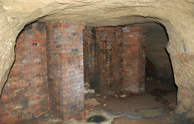
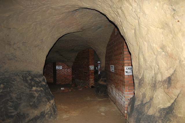
We headed from there—walking a brisk pace uphill into the town center—with David casually narrating the various basements, cellars, tunnels, and other urban perforations that lay under the buildings around us, as if we were traveling through town with a human x-ray machine for whom the city was an archaeologically rich cobweb of underground loops and dead-ends.
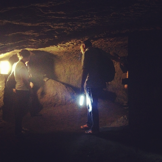
We soon ended up at the old jails of the Galleries of Justice. A well-known tourist destination, complete with costumed re-enactors, the building sits atop several levels of artificial caves that are well worth exploring.
We were joined at this point by the site’s director, who generously took time out of his schedule to lead us down into parts of the underground complex that are not normally open to the general public.
Heading downward—at first by elevator—we eventually unlocked a door, stepped into a tiny room beneath even the jail cells, crouching over so as not to bang our heads on the low ceiling, and we leaned against banded brick pillars that had been added to help support all the architecture groaning above us.
Avoiding each other’s flashlight beams, we listened as our two guides talked about the discovery—and, sadly, the willful reburial—of caves throughout central Nottingham.
[Image: Brick pillars below Nottingham; photo by BLDGBLOG].
We learned, for instance, that, elsewhere in the city, there had once been a vacuum shop with a cave beneath it; if I remember this story correctly, the shop’s owners had the habit of simply discarding broken and unsold vacuum cleaners into the cave, inadvertently creating a kind of museum of obsolete vacuum parts. Discontinued models sat in the darkness—a void full of vacuums—as the shop went out of business.
We heard, as well, about a nearby site where caves had been discovered beneath a bank during a recent process of renovation and expansion—but, fearing discovery of anything that might slow down the bank’s architectural plans, the caves were simply walled up and left unexplored. They’re thus still down there, underneath and behind the bank, their contents unknown, their extent unmapped—a fate, it seems, shared by many of the caves of Nottingham.
Rather than being greeted by the subterranean and historical wonder that such structures deserve—and I would argue that essentially all of subterranean Nottingham should be declared a UNESCO World Heritage Site—the caves are too often treated as little more than annoying construction setbacks or anomalous ground conditions, suitable only for bricking up, filling with concrete, or forgetting. If the public thinks about them at all, in seems, it is only long enough to consider them threats to building safety or negative influences on property value.
[Images: Learning about caves; photos by BLDGBLOG].
In any case, on our way out of the Galleries of Justice, we lifted up a ventilation grill in the floor and looked down into a small vertical shaft, too narrow and contorted even for Ellis to navigate, and we learned that there are urban legends that this particular shaft leads down to a larger room in which Robin Hood himself was once held… But we had only enough time to shine our flashlights down and wonder.
[Images: Ellis Smout looks for Robin Hood below; photos by BLDGBLOG].
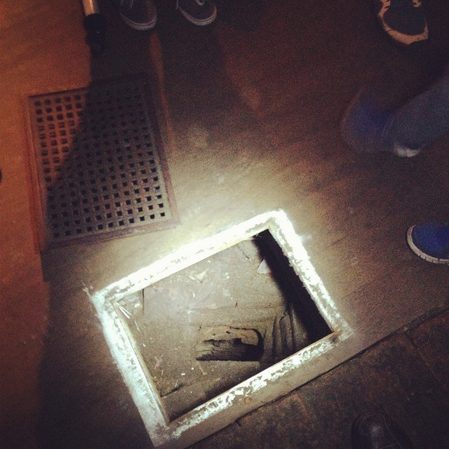
From here, we headed over to our final tourist-y site of the day, which is the awesomely surreal City of Caves exhibition, located in Nottingham’s Broad Marsh shopping mall.
You literally take an escalator down into an indoor mall, where, amidst clothing outlets and food courts, there is an otherwise totally mundane sign pointing simply to “Caves.”
If you didn’t know about Nottingham’s extensive sub-city, this would surely be one of the most inexplicable way-finding messages in mall history.
Here, where we picked our copy of Tony Waltham’s Sandstone Caves of Nottingham pamphlet, from which I’ve been quoting, we learned quite a bit more about how the city has grown, how the caves themselves have often been uncovered (for example, during building expansions and renovations), and what role Nottingham’s underground spaces served during the Nazi bombings of WWII.
[Image: Beneath Broad Marsh shopping mall; photo by BLDGBLOG].
The specific underground complex beneath the shopping mall offers an interesting mix of old tanning operations and other semi-industrial, pre-modern work rooms, now overlapping with 20th-century living and basement spaces that were sliced open during the construction of the Broad Marsh mall.
[Images: Cave spaces beneath the Superstudio-like concrete grid of Nottingham’s Broad Marsh shopping Mall].
That these caves were preserved at all is testament to the power of local conservationists, as the historically rich and spatially intricate rooms and corridors would have been gutted and erased entirely during post-War reconstruction without their intervention.
As it now stands, the mall is perched above the caves on concrete pillars, with the effect that curious shoppers can wander down into the caves through an entrance that could just as easily lead to a local branch of Accessorize.
[Image: A well bucket in the caves beneath Broad Marsh; photo by BLDGBLOG].
Again, we were fortunate to be taken down into some off-limits areas, stepping over lights and electric wires and peering ahead into larger rooms not on the tourist route.
[Images: Lines of lights we switched on in one of the off-limits rooms below Broad Marsh; photo by BLDGBLOG].
This included stepping outside at one point to wander through an overgrown alleyway behind the mall. Small openings even back here stretched beneath and seemingly into the backs of shops; one doorway, a short scramble up a hill of weed-covered rubble, appeared to contain a half-collapsed spiral staircase installed inside a brick-lined sandstone opening.
[Image: A doorway to voids behind Broad Marsh Centre; photo by BLDGBLOG].
At this point, we began to joke about the ease with which it seemed you could plan a sort of speleological super-heist, breaking into shops from below, as an entire dimension of the city seemed to lie unwatched and unprotected.
Nottingham, it appeared, is a city of nothing but doors and openings, holes, pores, and connections, complexly layered knots of space coiling beneath one building after another, sometimes cutting all the way down to the water table.
Incredibly, the day only continued to build in interest, reaching near-impossible urban sights, from catacombs in the local graveyard to a mind-bending sand mine that whirled and looped around like smoke rings beneath an otherwise quiet residential neighborhood.
Leaving the mall behind, and maintaining a brisk pace, David took us further into the city, where our next stop was the Old Angel Inn, another pub with an extensive cellar of caves, in this case accessed through a deceptively workaday door next to an arcade game.
[Images: The Old Angel Inn (top), including the door inside the pub that leads down to the caves below; photos by Nicola Twilley].
Once again, it can hardly be exaggerated how easy it would be to visit or even live in Nottingham and have absolutely no idea that underground spaces such as this can be found almost anywhere. As Tony Waltham points out, “It would be a fair assumption that every building or site within the old city limits either has or had some form of cave beneath it. About 500 caves are now known, and this may be only half the total number that have been excavated under Nottingham.”
In any case, “Although the Old Angel is a ‘modern’ brick building,” as the Nottingham Caves Survey describes the pub on its website, “an investigation of the caves below reveals stone walls belonging to an earlier incarnation. It is likely that there were buildings on this site as far back as the Anglo-Saxon period. Whether the caves beneath are also this old cannot be demonstrated definitively.”
Typical, as well, for these types of pub caves, we found ventilation and delivery tunnels leading back up to the surface, and the walls themselves are lined with long benches, perfect for sitting below ground and, provided you have candles or a flashlight along with you, enjoying a smoke and a pint of beer. As Tony Waltham explains, pub cellars often include “perimeter thralls,” or “low ledges cut in the rock,” normally used for storing kegs and barrels of beer but quite easily repurposed for a quick sit-down.
But I sense I’m going on way too long about all this, especially because the two most memorable details of the entire day were yet to come.
Jumping forward a bit, we left the Old Angel and followed some twists and turns in the street to find ourselves standing outside a nightclub called Propaganda.
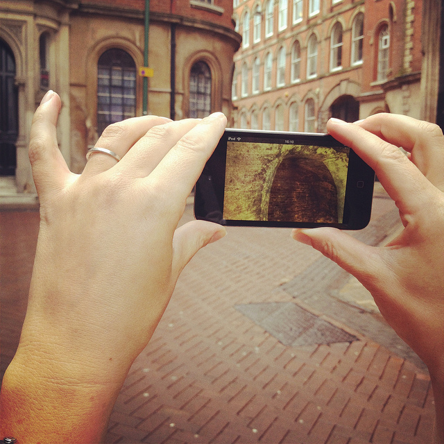
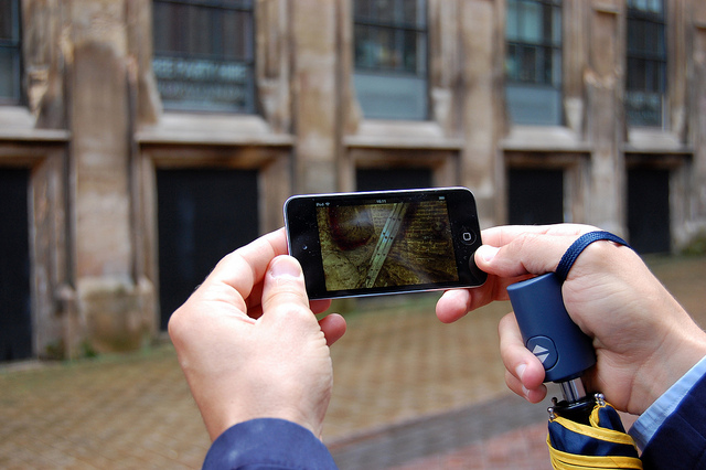
Here, David revealed that he has been working on what, in my opinion, will easily be one of the must-have apps of the year. In a nutshell, David has managed to make the subterranean 3D laser-scans of the Nottingham Caves Survey accessible by location, such that, holding up his iPod Touch, he demonstrated that you could, in effect, scan the courtyard we were standing in to see the caves, tunnels, stairways, cellars, vents, storage rooms, and more that lay hidden in the ground around us.
[Images: We test-drive the cave-spotting app; bottom photo by Nicola Twilley].
Ideally, once the Survey’s extensive catalog of 3D visualizations and laser point-clouds has been made available and the app is ready for public download, you will be able to walk through the city of Nottingham, smartphone in hand, revealing in all of their serpentine complexity the underground spaces of the city core.
For anyone who has ever dreamt of putting on x-ray glasses and using them to explore architectural space, this app promises to be a thrilling and vertiginous way to experience exactly that—peering right through the city to see its most ancient foundations.
[Video: A fly-through of the Propaganda Nightclub malting caves].
I, for one, can’t wait to see what David and the Nottingham Caves Survey do with the finished application and I eagerly await its public availability.
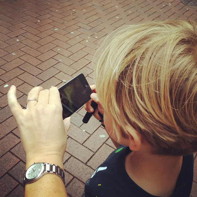
[Image: Mark Smout looks for caves in the sky; photo by Nicola Twilley].
I’ll wind up this already quite long post with just a few more highlights.
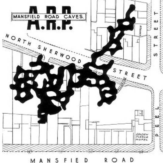
Nottingham’s Rock Cemetery, north from the center of town along the Mansfield Road, contains, among other things, the collapsed remains of a sand mine. Three of the mine’s old entrances are now gated alcoves surrounded by graves, like something out of Dante. They “are the only surviving remnants of the mine,” Waltham writes in his pamphlet.
[Images: Nottingham’s Rock Cemetery, where archaeologist David Strange-Walker explained the history of the local landscape].
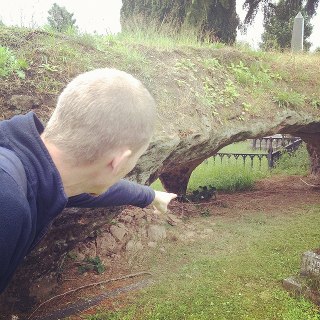
However, an ambitious plan to carve sizable catacombs, inspired by Paris and Rome, through the sandstone beds of the ancient desert here resulted in the never-completed Catacomb Caves, “probably done in 1859-63,” Waltham suggests. These long arched tunnels, accessible through one of the gates described above, eventually lead to a radial terminus from which branch the unused proto-catacombs.
The air there is cloudy with sand—leading me, several days later, to experience a brief attack of hypochondria, worried about developing silicosis—the walls are graffiti’d, and years of trash are piled on the sides of the sandy floor (which has since taken on the characteristics of a dune sea in places, as 150 years of footfall and a collapsing ceiling have led to the appearance of drifts).
[Images: The Rock Cemetery catacomb gates].
What was so extraordinary here, among many other things, was that, for most of this walk through the catacombs, we were actually walking below the graves, meaning that people were buried above us in the earth. At the risk of overdoing it, this felt not unlike becoming aware of an altogether different type of constellation, with bodies and all the stories their lives could tell held above us in a terrestrial sky like legends and heroes, like Orion and Cassiopeia, as we looked up at the vaulted ceiling, flashlights in hand.
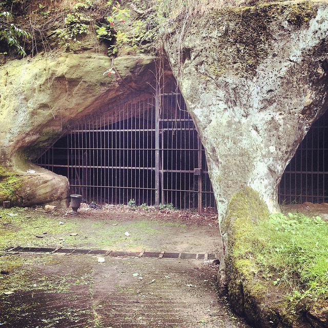
[Image: A door on the street—the black door with bars—leading down into a sand mine; photo by BLDGBLOG].
Serving as something of the ultimate proof that Nottingham is a city of overlooked doors that lead into the underworld, there were two locked doors—one of which (the black door, near the sidewalk) appears in the photo, above, another of which, on a street nearby, leads down into the Peel Street Caves—simply sitting there on the sidewalk that, if opened, will take you down into extensive and now defunct sand mines. David’s laser-scans of these for the Nottingham Caves Survey are absolutely gorgeous, as you can see, below.
For a variety of reasons, I am going to avoid being too specific about some of the details here, but, aside from that, I can only enthuse about the experience of donning our hard hats and heading down several flights of comparatively new concrete steps into a coiling and vast artificial cavern from the 19th century, one we spent nearly an hour exploring.
[Image: Nicola Twilley and Mark Smout head down into the sand mine; photo by BLDGBLOG].
Getting lost down there would be so absurdly easy that it is frightening even to contemplate, and, in case the group of us somehow got split up or our batteries ran out of juice, we joked about—if only we could remember them—the easy techniques for navigating a labyrinth offered in Umberto Eco’s novel The Name of the Rose.
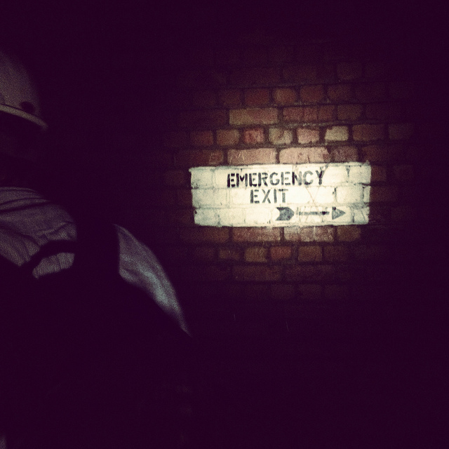
[Image: Many of these way-finding signs are actually incorrect, David explained, and seem to have been painted as a kind of sick joke by someone several years ago; photos by BLDGBLOG].
Avoiding such a fate, however, we found graffiti and men’s and women’s latrines; we popped our heads through holes allowing glimpse of other levels; and we cracked our helmets loudly against the low and rough roof more times than I could count.
[Images: Inside the sand mine; all photos by Nicola Twilley].
And even that doesn’t complete the day. From here, heading back out onto the street through a nondescript steel door, as if we had been doing nothing more than watching football in someone’s basement, we went on to eat pie and chips in a restaurant built partially into a cave; we walked back across town, returning to where we started, talking about the future and seemingly obvious possibility of Nottingham’s caves being declared a UNESCO World Heritage Site and thus saved from their all but inevitable destruction (it’s easy to imagine a future in which a tour like the one David gave us will be impossible for lack of caves to see); and we all said goodbye beneath an evening sky cleared of clouds as a late-day breeze began to cut through town.
[Image: Mark & Ellis Smout explore our final “underground” space of the day, the magnificent Park Tunnel; the banded strata clearly visible in the walls show how the tunnel was carved through the dunes of an ancient desert. Photo by BLDGBLOG].
David proved to be a heroic guide that day. His energy never flagged throughout the tour, and he never once appeared impatient with or exhausted by any of our often ridiculous questions—not to mention our tourists’ insistence on pausing every three or four steps to take photographs—and he remained always willing to stay underground far longer than he had originally planned, all this despite having never met any of us before in person and only communicating with me briefly via a flurry of emails the week before.
Meeting David left me far more convinced than I already was that the Nottingham Caves Survey fully deserves the financial support of individuals and institutions, so that it can complete its ambitious and historically valuable work of cataloging Nottingham’s underground spaces and making that knowledge freely accessible to the general public.
Weirdly, England has within its very heart a region deserving comparison to Turkish Cappadocia—yet very few people even seem to know that this subterranean world exists. There very well could be more than 1,000 artificial caves beneath the city, many of them fantastically elaborate, complete with fine carvings of lions and ornate stairwells, and it is actually somewhat disconcerting to think that people remain so globally unaware of Nottingham’s underground heritage.
With any luck, the work of David Strange-Walker, Trent & Peak Archaeology, and the Nottingham Caves Survey will help bring this extraordinary region of the earth the attention—and, importantly, the focused conservation—it is due.
(For further reading, don’t miss Nicola Twilley’s write-up of the tour on her own blog, Edible Geography; and Tony Waltham’s Sandstone Caves of Nottingham, cited extensively in this post, is worth a read if you can find a copy).
In what sounds like the plot of a bad horror film, we read that “kids in Picher, Okla., are exposed to lead, and the ground is at risk of cave-ins” due to the “abandoned mines beneath the city.”
Turns out the whole town is now under “voluntary buyout” by the US government because the place is so polluted that no one should be living there. Tailings from abandoned lead and zinc mines are to blame; indeed, there are “giant gray piles of mining waste, known locally as ‘chat,’ some hundreds of feet tall and acres wide, that loom over abandoned storefronts and empty lots.”
[Image: “Chat piles” looming round the “abandoned storefronts and empty lots” of Picher, OK; photo by Matt Wright, author of the article I’ve been quoting. See also this photo gallery from the US Geological Survey’s own tour of Picher, or this series of images from 1919].
Signs of Picher’s impending death are everywhere. Many stores along Highway 69, the town’s main street, are empty, their windows coated with a layer of grime, virtually concealing the abandoned merchandise still on display. Trucks traveling along the highway are diverted around Picher for fear that the hollowed-out mines under the town would cause the streets to collapse under the weight of big rigs. (!) In some neighborhoods, empty mobile homes sit rusting in the sun, their windows broken, their doors yawning open, the detritus of life—car parts, broken toys, pieces of carpet, rotting sofas—strewn across their front yards.
But what happens in twenty years’ time, when a group of joy-riding teenagers from across state lines find themselves driving through Picher in the late afternoon…? They park their car, laughing, and throw rocks through some windows; one of them sneaks behind the old neighborhood Piggly Wiggly and opens up the door of a small shed only to find the entrance to a mine—when, suddenly, the ground opens up on the main street and swallows all three of his friends.
He hears screaming—as well as what sound like whispering voices coming from beneath the ground. The sun setting, our naive hero of the high school football squad descends into the lead mines to find them…
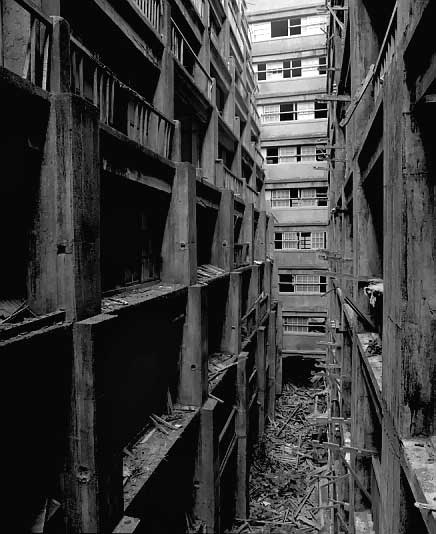
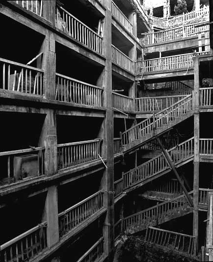
“Off the westernmost coast of Japan,” we read, “is an island called ‘Gunkanjima’ that is hardly known even to the Japanese.”
Long ago, the island was nothing more than a small reef. Then in 1810, [with] the chance discovery of coal … people came to live here, and through coal mining the reef started to expand continuously. Befor [sic] long, the reef had grown into an artificial island of one kilometer (three quarters of a mile) in perimeter, with a population of 5300. Looming above the ocean, it appeared a concrete labyrinth of many-storied apartment houses and mining structures built closely together.
“Seen from the ocean,” the site continues, “the silhouette of the island closely resembled a battleship – so, the island came to be called Gunkanjima, or Battleship Island.”
The idea of an entirely artificial mining island seems to lie somewhere between James Bond and Greek mythology. I’ve always wanted to write a short story about a mineral-rich island where a man similar to Conrad’s Kurtz sets up a mining operation; in mining the mineral wealth of his new little island, the architecture and structural engineering – the gantries, vaults, platforms, roads, etc. – come to be built from the island itself. Eventually the island entirely disappears beneath the waterline, mined down to nothing – and yet a small stilt-city of mining platforms, engineering decks, control rooms, and cantilevered walkways still exists there, built from the island it all now replaces.
In The Scar by China Miéville, there’s a floating city made from tightly lashed-together hulls of ships, built so densely that, for those deep within it, it appears simply to be a particularly over-built – albeit floating – island. The rudders and keels of old boats cut through the water at angles contrary to the direction that the ship-island floats in, and thousands of anchors secure the city in place when it needs to find harbor.
What seems to be missing, at least to my experience, from architectural history & design courses are things like – drum roll – offshore mining derricks. Once again, it seems the wrong people are teaching our design labs: instead of more M.Arch grads who’ve read too much – or not enough – Deleuze, we need to bring in junior executives from BP or Halliburton, geologists and NASA engineers, and put them into dialogue with Situationism – and, why not, with China Miéville. Science fiction writers. Get ideas out of the one side, practical engineering science out of the other, and shebang…
What could that produce…? is a legitimate question. A terrible example, but still marginally interesting I think, would be something like the Burning Man festival, thrown not in the desert but in the middle of the Atlantic Ocean. A joint-venture between BP, Halliburton, and Peter Cook of Archigram. And the Mars Homestead Project. Seaborne utopias. Platform cities. Perhaps Atlantis was built by a battalion of rogue Roman engineers lost to history.
It’s not Damien Hirst, Daniel Libeskind, Matthew Barney, or Norman Foster we should be watching, neither artistically nor architecturally, I mean; it’s the Chief Operating Officers of offshore oil-services firms. The architectural patrons of today are not avant-garde, middle class Connecticut home-owners but logistical managers in the US Department of Energy. New building types are not being discovered or invented in the design labs of American architectural offices, but in the flowcharts and budgetary projection worksheets of multinational petrochemical firms. Forget Spiral Jetty – we need a platform city built above the mid-Atlantic rift, an uninhabited, reinforced concrete archipelago ideal for untrained astronomical observation. The Reef Foundation – you win their residency grant and get to spend six months alone staring at the sun on a perfectly calibrated Quikrete lily pad.
We need the wastrel sons of hedge fund billionaires out there patronizing manmade archipelagos in the South China Sea.
 [Image: Nickel-rich sap; photo by Antony van der Ent, courtesy New York Times.]

 [Images: Photos by BLDGBLOG.]
 [Image: Empty homes in Picher, Oklahoma; photo by
  [Image: Picher, surrounded by its toxic artificial landforms; via
  [Image: Courtesy U.S. Department of the Interior Bureau of Ocean Energy Management (
 [Images: Courtesy U.S. Department of the Interior Bureau of Ocean Energy Management (
 [Image:
  [Image:
  [Image:
  [Image: Inside
  [Image:
 [Images:
  [Image:
  [Image:
  [Image: Drone footage of a Cornwall garden sinkhole, via the
  [Image: Photo courtesy
 [Image: From “
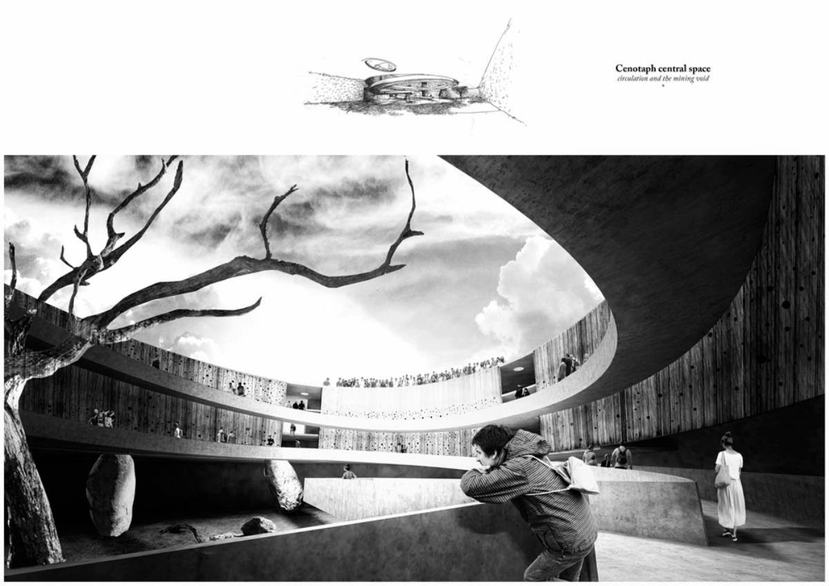 [Image: From “
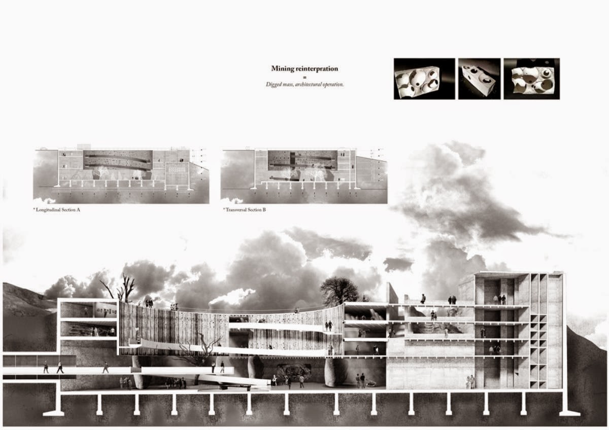 [Image: From “
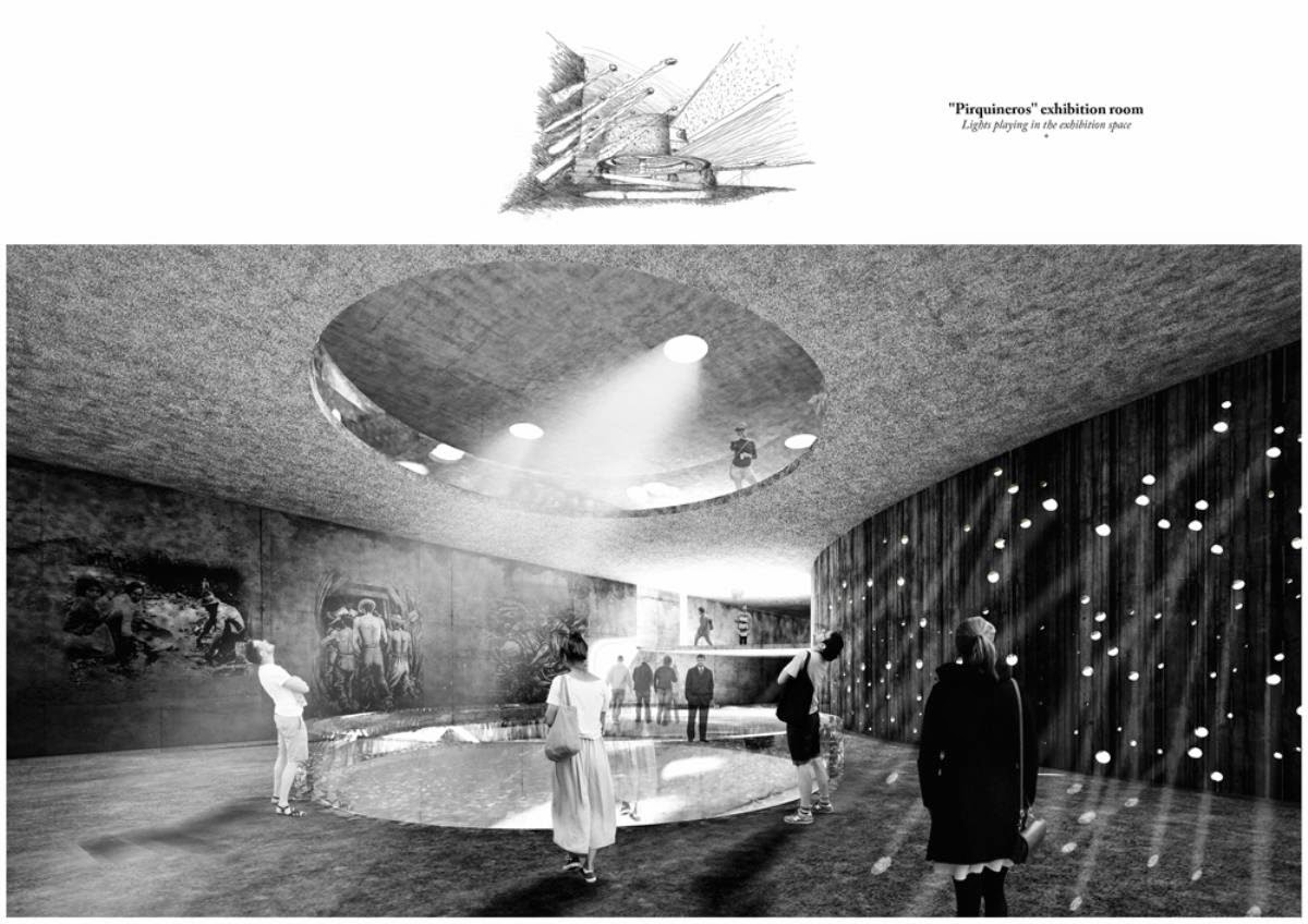 [Image: From “
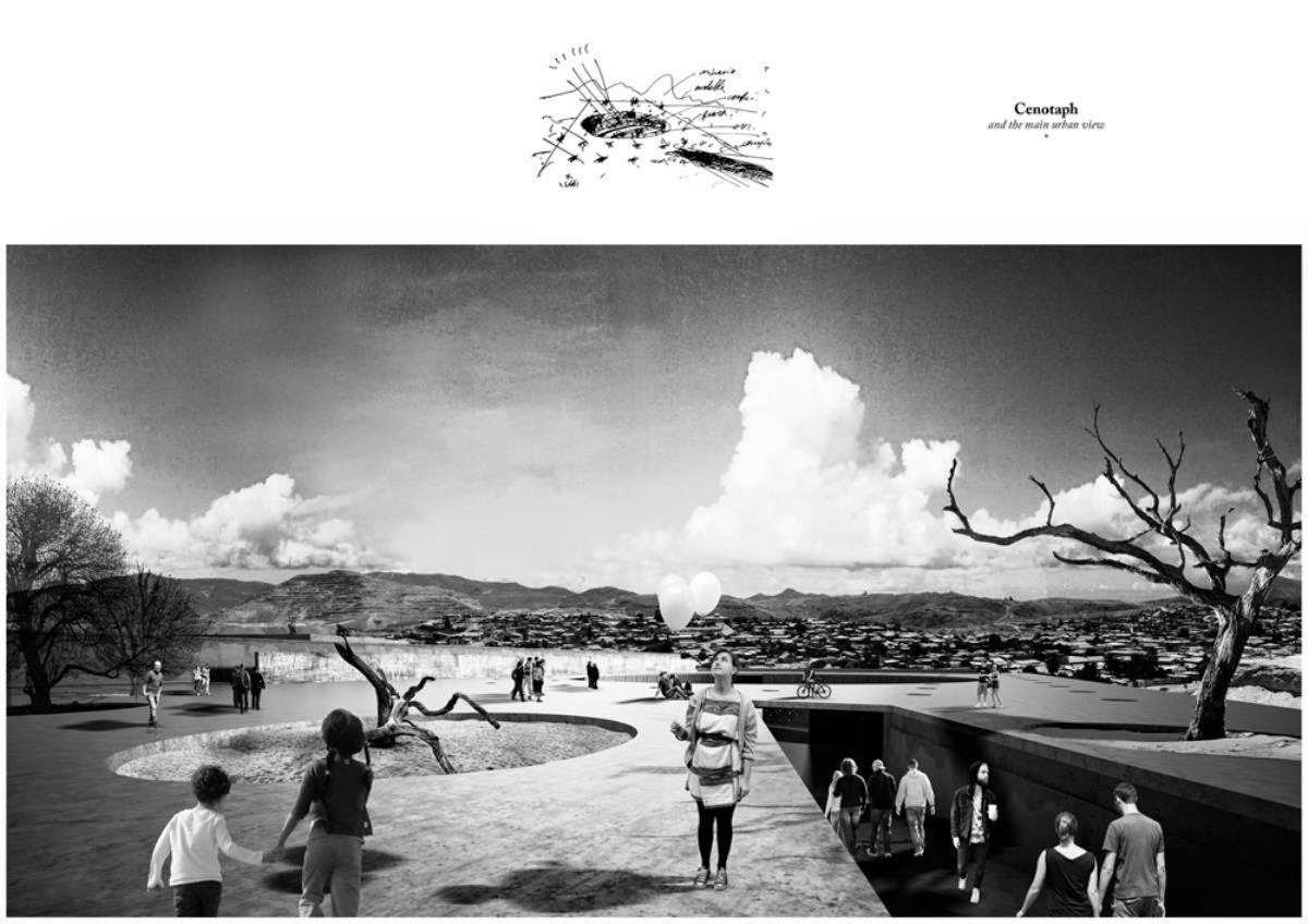 [Image: From “
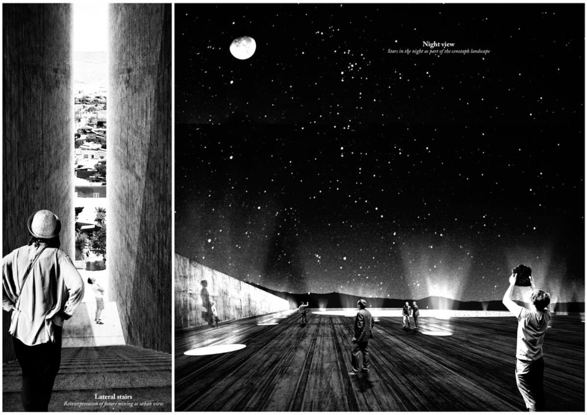 [Image: From “
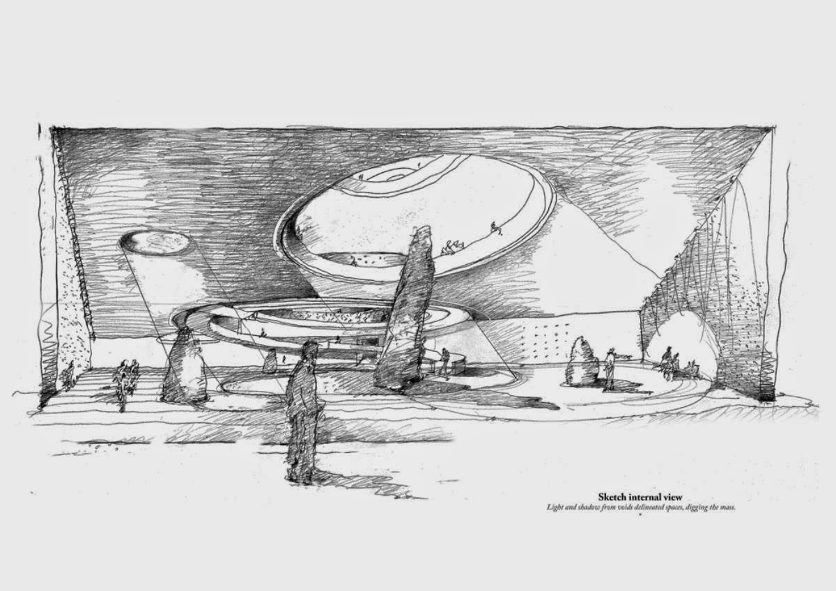 [Image: From “
 [Image: The “
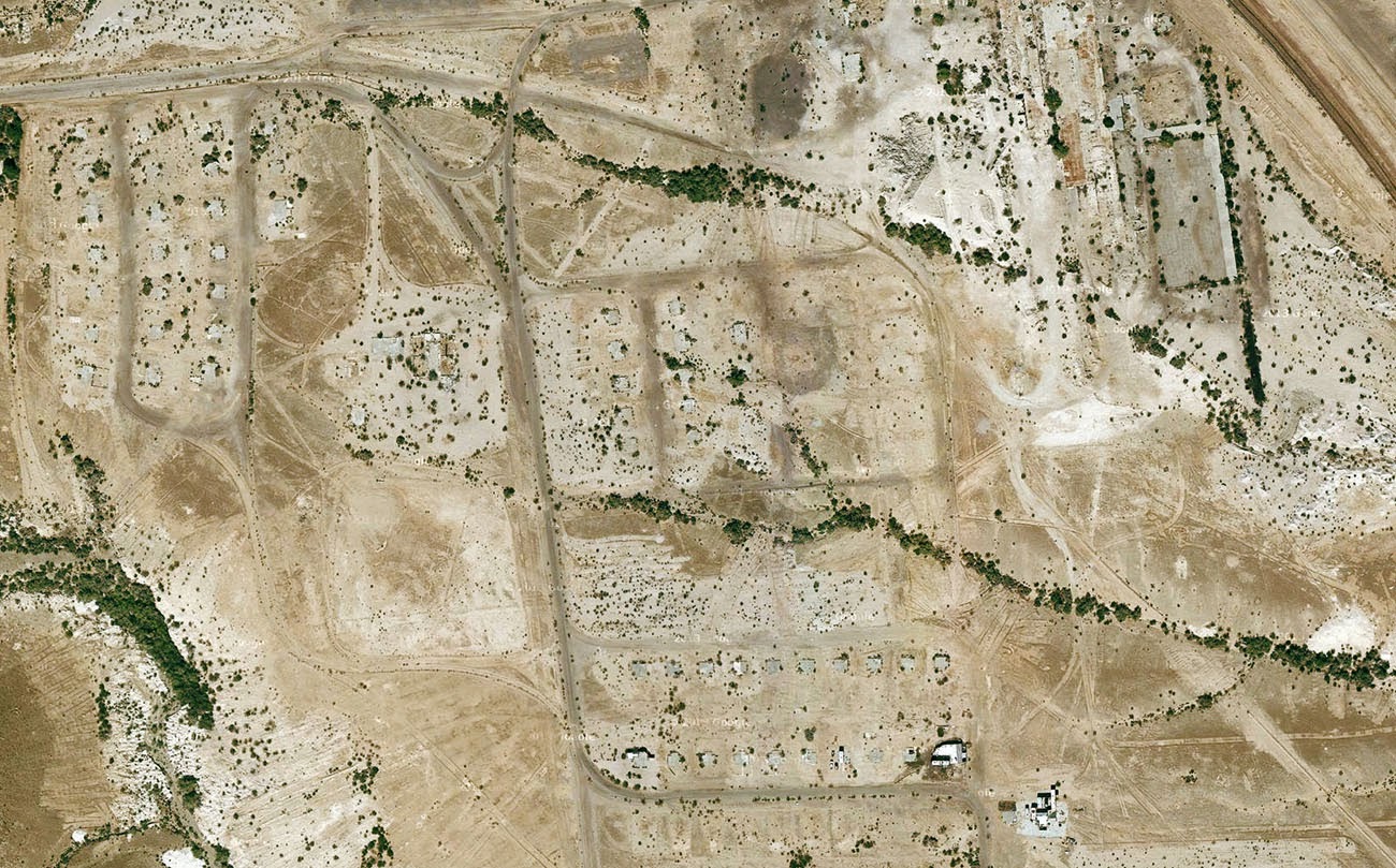 [Image: Midland, California, via
 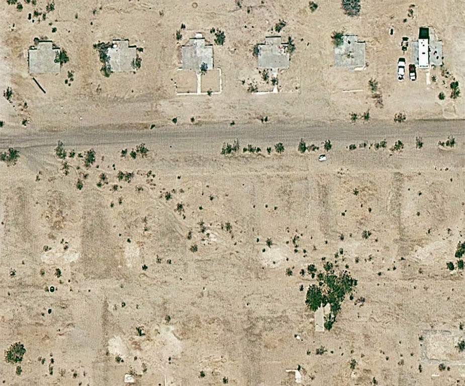 [Image: Midland, California, via
 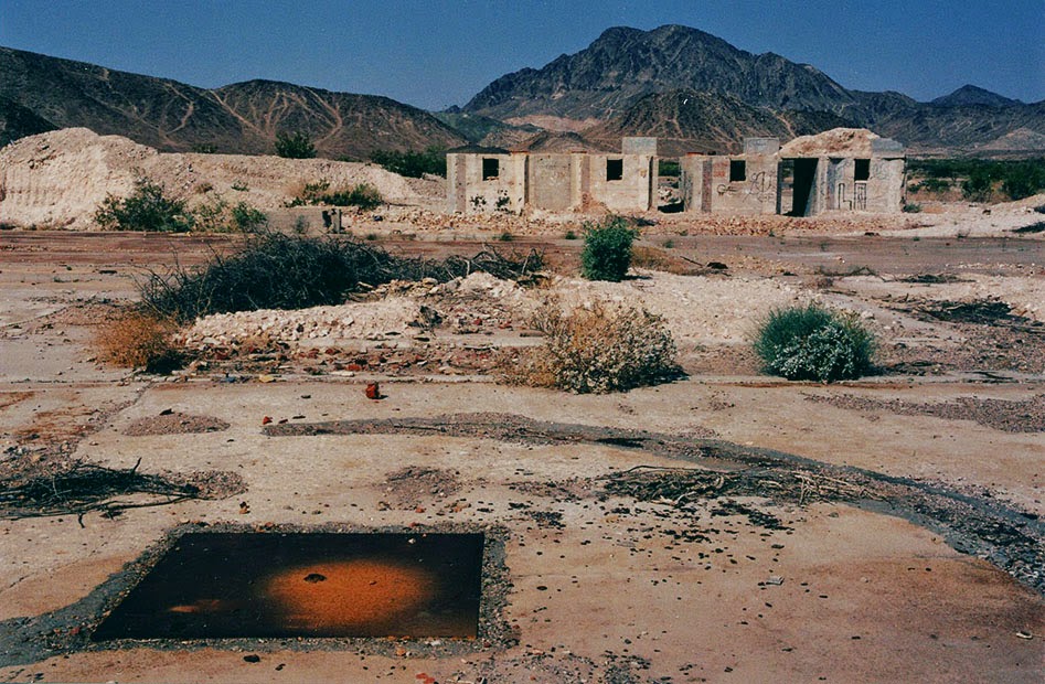 [Image: The abandoned streets of
 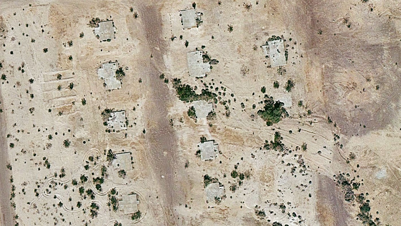 [Image: Midland, California, via
 [Image: Cliffs and caves of Nottingham; photo by
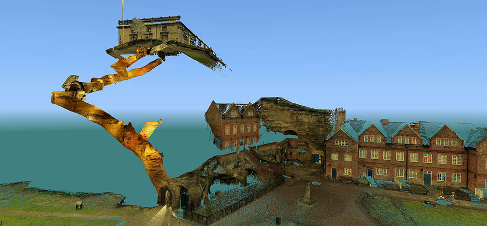
 [Images: Laser scans from the
 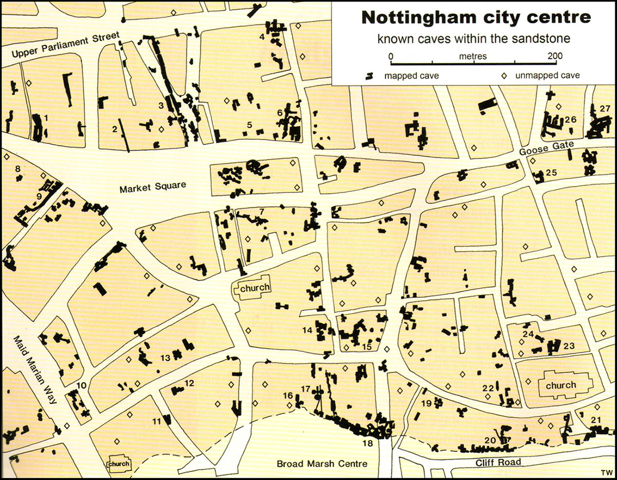 [Image: Map of only the known caves in Nottingham, and only in Nottingham’s city center; map by Tony Waltham, from
 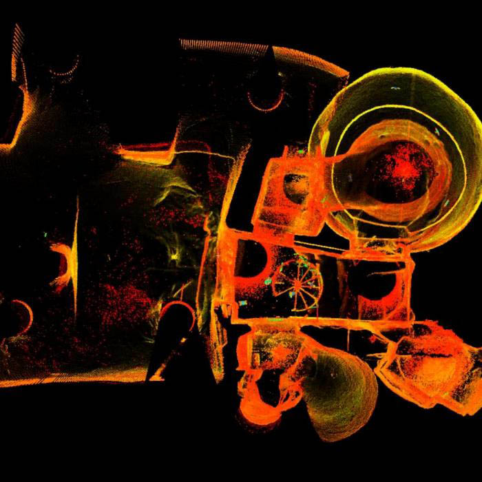 [Image: The extraordinary caves at
 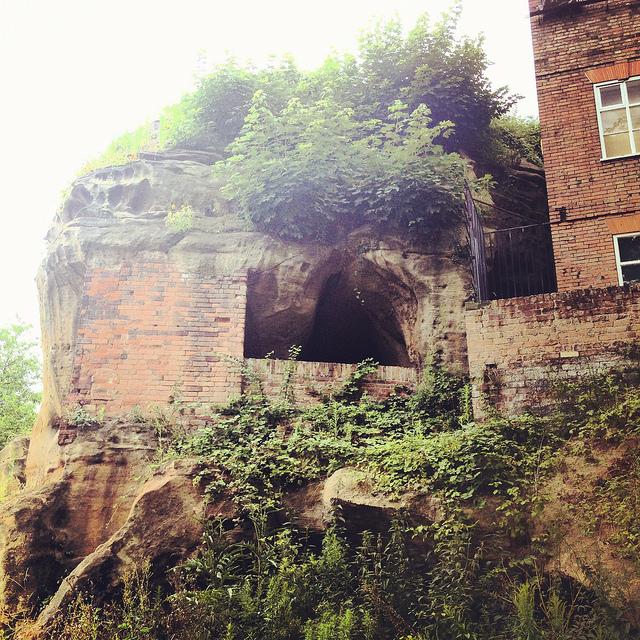 [Image: Artificially enlarged pores in the sandstone; photo by BLDGBLOG].
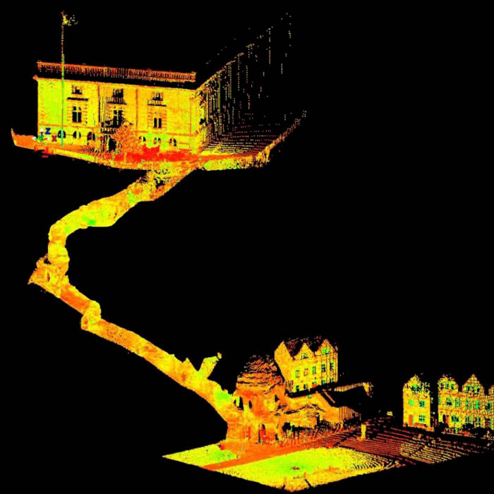 [Image: A laser scan showing the umbilical connection of
 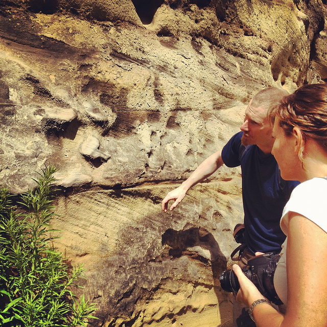 [Image: Examining sandstone with Dr. David Strange-Walker; photo by BLDGBLOG].
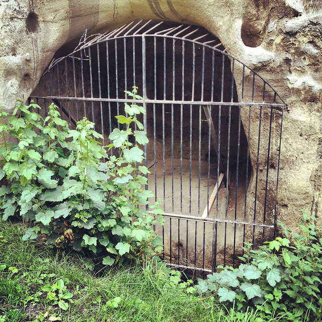 [Image: A gate in the cliff; photo by BLDGBLOG].
 [Image: Artificial shotcrete geology; photo by BLDGBLOG].
 [Image: Scan of the Guildhall caves, courtesy of the
 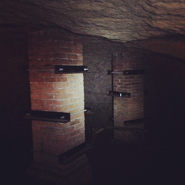 [Image: Brick pillars below Nottingham; photo by BLDGBLOG].
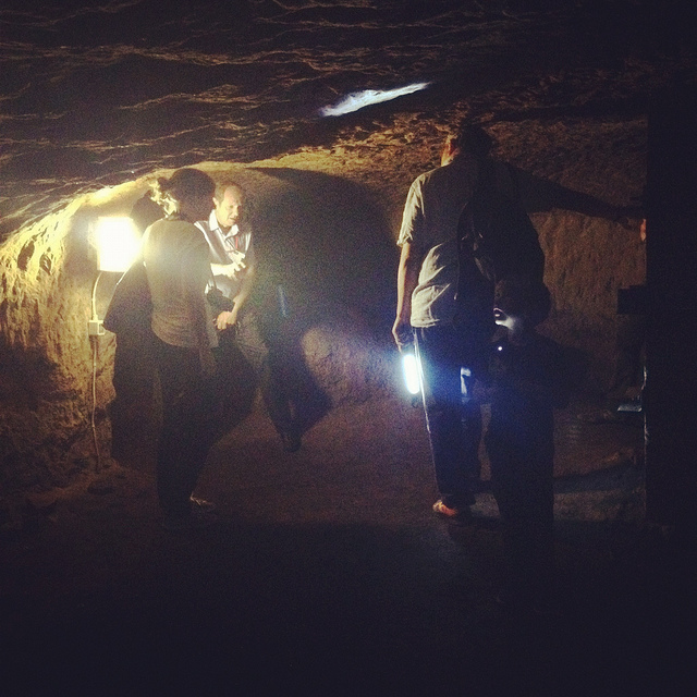
 [Images: Learning about caves; photos by BLDGBLOG].
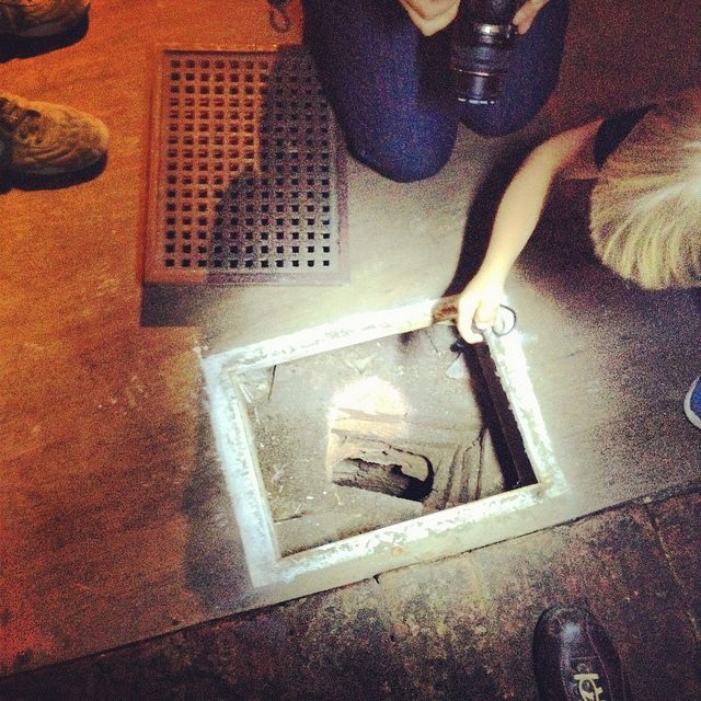
 [Images: Ellis Smout looks for Robin Hood below; photos by BLDGBLOG].
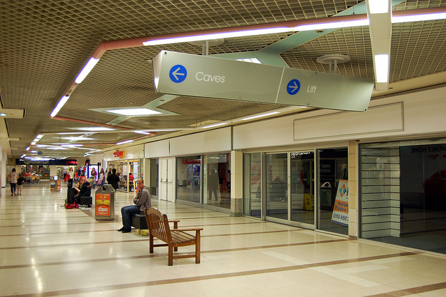 [Image: Caves; photo by
 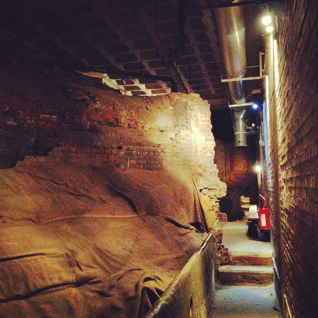 [Image: Beneath Broad Marsh shopping mall; photo by BLDGBLOG].
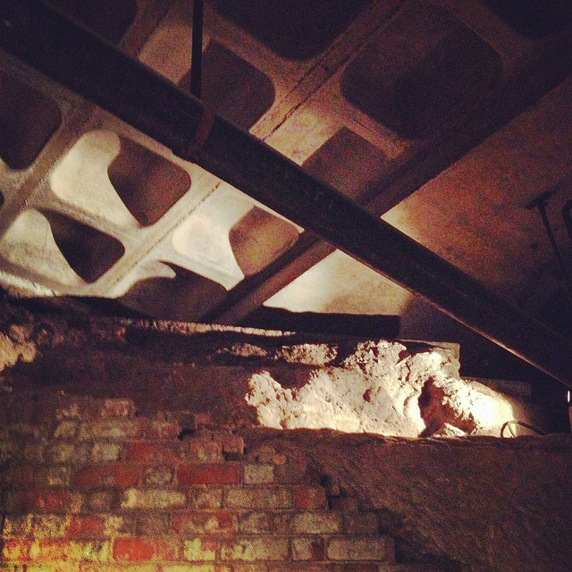
 [Images: Cave spaces beneath the Superstudio-like concrete grid of Nottingham’s Broad Marsh shopping Mall].
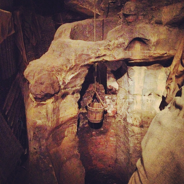 [Image: A well bucket in the caves beneath Broad Marsh; photo by BLDGBLOG].
 [Images: Lines of lights we switched on in one of the off-limits rooms below Broad Marsh; photo by BLDGBLOG].
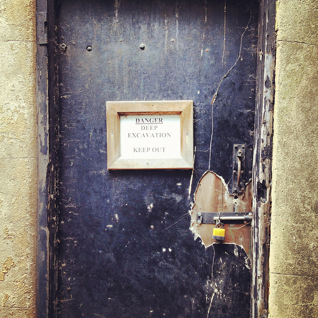 [Image: A doorway to voids behind Broad Marsh Centre; photo by BLDGBLOG].
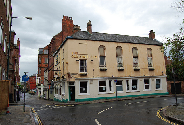
 [Images: The Old Angel Inn (top), including the door inside the pub that leads down to the caves below; photos by
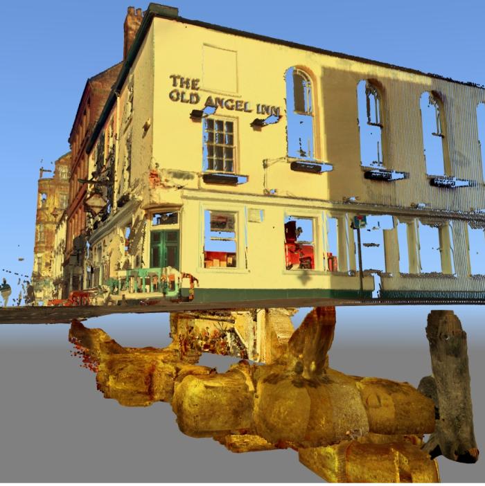
 [Images: The caves of the Old Angel Inn, courtesy of the
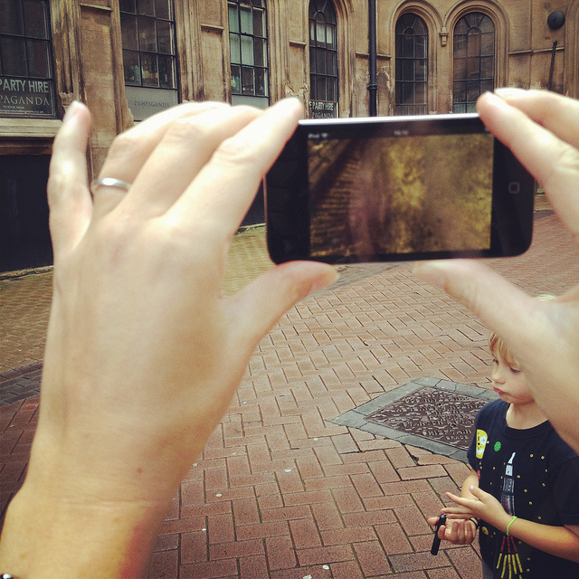
 [Images: We test-drive the cave-spotting app; bottom photo by
 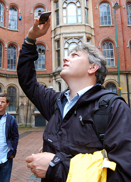 [Image: Mark Smout looks for caves in the sky; photo by
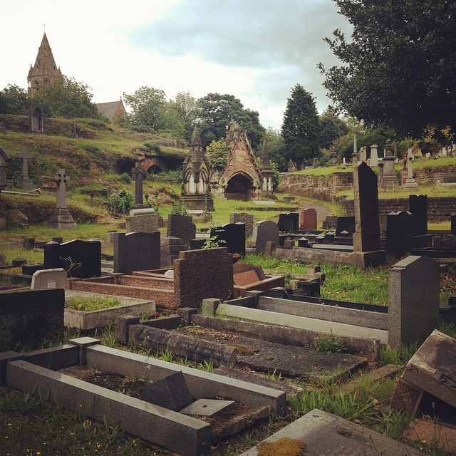
 [Images: Nottingham’s Rock Cemetery, where archaeologist David Strange-Walker explained the history of the local landscape].
 [Images: The Rock Cemetery catacomb gates].
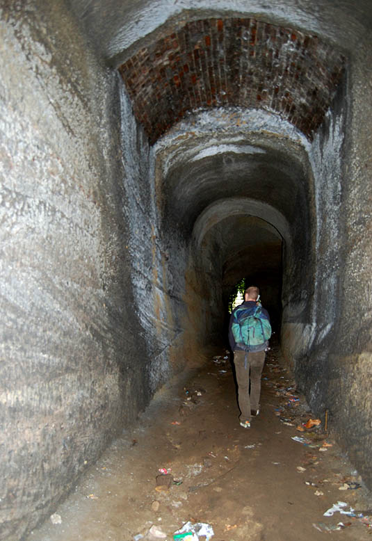 [Image: Inside the catacombs; photo by
  [Image: A door on the street—the black door with bars—leading down into a sand mine; photo by BLDGBLOG].
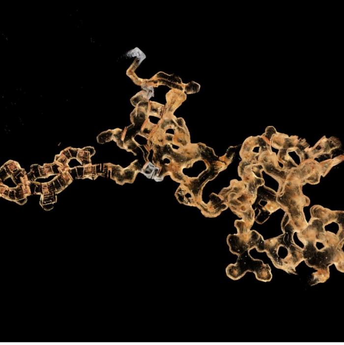
 [Image: The
 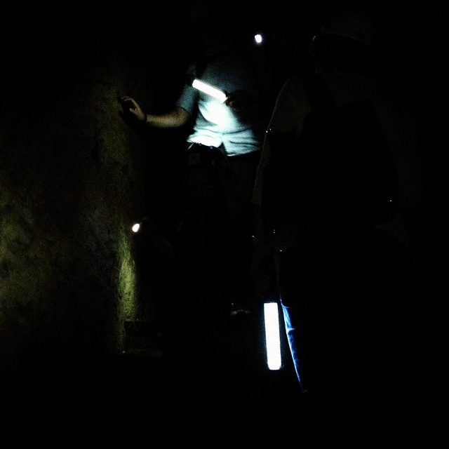 [Image: Nicola Twilley and Mark Smout head down into the sand mine; photo by BLDGBLOG].
 [Image: Many of these way-finding signs are actually incorrect, David explained, and seem to have been painted as a kind of sick joke by someone several years ago; photos by BLDGBLOG].
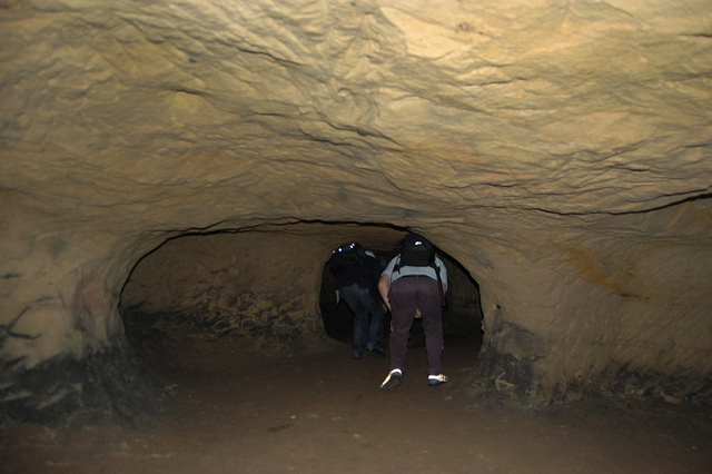
 [Images: Inside the sand mine; all photos by
 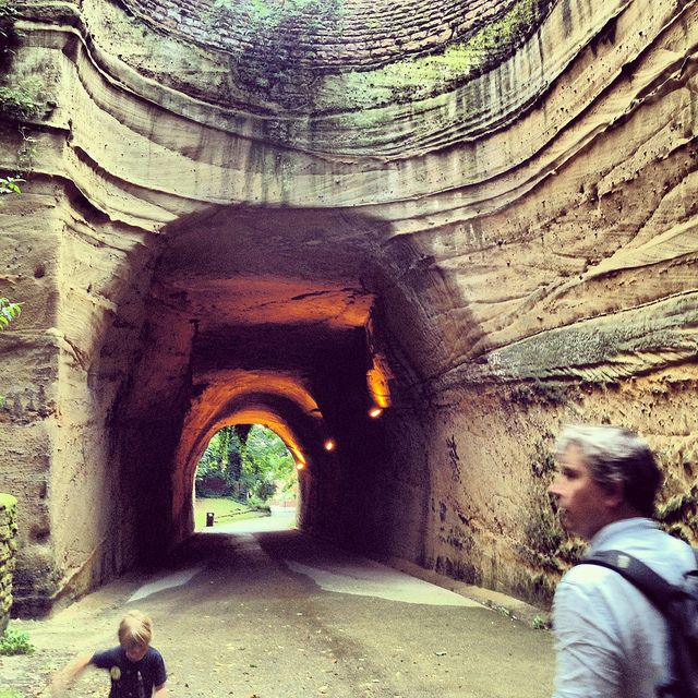 [Image: Mark & Ellis Smout explore our final “underground” space of the day, the magnificent Park Tunnel; the banded strata clearly visible in the walls show how the tunnel was carved through the dunes of an ancient desert. Photo by BLDGBLOG].
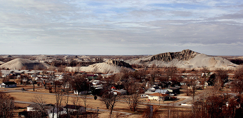 [Image: “Chat piles” looming round the “abandoned storefronts and empty lots” of Picher, OK; photo by
 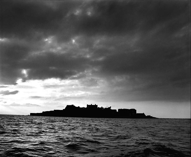 [Image: Gunkanjima Island (
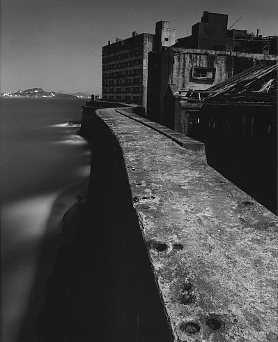

 [Images: Gunkanjima Island (
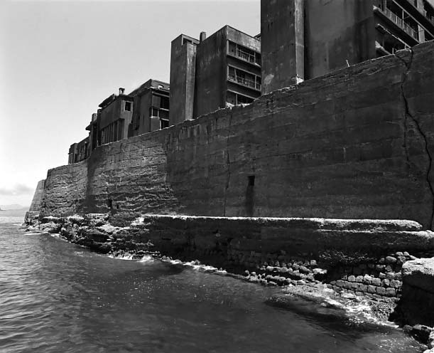 [Image: Gunkanjima Island (
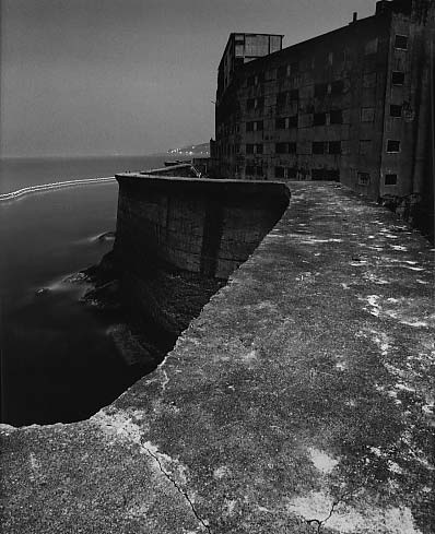 [Image: Gunkanjima Island (
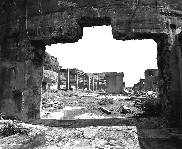 [Image: Gunkanjima Island (