House on the Border

There’s a great detail in a recent news story about cross-border smuggling in a small northern township, where upstate New York meets Quebec. Some homes in Dundee straddle the international border between the U.S. and Canada (recalling the marbled, enclave-rich border town of Baarle-Hertog or even Derby Line, Vermont).

In a report about a man arrested for gun-running, Radio-Canada refers to this man’s house as a “maison sur la frontière,” or house on the border: “located on Beaver Road, the house can be found in both Canada and the United States” (translating from French).

Indeed, although I cannot guarantee this is the right place, you can see a structure on Google Maps at the end of Beaver Road (Chemin Beaver) that sits astride the international border.

[Image: Via Google Maps.]

“Due to the presence of several such properties in Dundee,” the article continues, “this special location makes this municipality a historically recognized location for contraband, especially alcohol smuggling during the Prohibition era. It is therefore not new that properties along the border in this area have come under increased surveillance by the RCMP, which keeps an eye on real estate transactions and activities in the area.”

You take something in through the American side and just slide it across into Canada, crossing the border silently in the comfort of your own home.

As designer Daniel Benneworth-Gray joked on Twitter, residents could simply put everything on Lazy Susans “in case there’s a raid”: rotating furniture spun from one jurisdiction to the next in a house full of cross-border cupboards, compartments, and shelves, all connected to wheels, ropes, and pulleys, the whole place a kind of pinball machine through which illegal objects continually leave and re-enter the country.

The Magnetic Depths

The emerging sub-genre of public service announcements about geological surveys—apparently offered not just due to FAA regulations, but to quell the growth of potential conspiracy theories—continues with this heads-up about a “low-flying airplane” over parts of Virginia and North Carolina.

[Image: USGS map of eastern Virginia, altered by BLDGBLOG.]

Of course, beyond the idea of simply preempting the development of new conspiracy theories, the work being done by the project is fascinating in and of itself: “Instruments on the airplane will measure variations in the Earth’s magnetic field and natural low-level radiation created by different rock types near and up to several miles beneath the surface. This information will help researchers develop geologic maps of the area that will be used to better understand sand resources and underground faults in the region.”

While we’re on the topic of the Virginia/North Carolina border region, I’m reminded of why there’s a strange “notch” in the state line, a story “that mostly involves collecting taxes and avoiding swamps”: “The rough and rowdy inhabitants living close to the border told North Carolina tax collectors they lived in Virginia, [Gates County historian Linda Hofler] said. When the Virginia tax man came, they said North Carolina was their home.”

In any case, check out the USGS for more on the low-flying geomagnetic airplane and The Virginian-Pilot for more on VA/NC border history.

(Related: Geomedia, or What Lies Below.)

Buy a Border Patrol Station

[Image: Courtesy U.S. Government Services Administration].

Somewhat amazingly, a former U.S. Border Patrol station is for sale outside the town of Gila Bend, Arizona.

The minimum bid is only $8,000—but the property doesn’t look too good and is “not warranted,” so buyer beware.

[Image: Courtesy U.S. Government Services Administration].

Structural conditions notwithstanding, this could be an amazing opportunity to create a Border Museum, a desert arts center, a writers’ retreat, an urban explorers’ redoubt, a remote branch of the Center for Land Use Interpretation, a field school for an avant-garde university geography program, a pop-up site for an architecture school to host student installations, a future restaurant, a weird Father’s Day gift, a place to store your favorite Paul Manafort trial memorabilia, an asbestos-exposure demonstration facility, or just a roadside site to park your pick-up truck.

Here is the facility on Google Maps.

[Image: Courtesy U.S. Government Services Administration].

Bidding begins on August 28th.

[Image: Courtesy U.S. Government Services Administration].

Note that there is an open house on Friday morning, August 17th, 2018, at 9am, for those of you near Gila Bend.

(Previously on BLDGBLOG: Buy a Los Angeles Sidewalk Corner, Buy a Complex of Submarine Pits, Buy a Skyway, Buy a Fort, Buy a Lighthouse, Buy an Underground Kingdom, Buy a Prison, Buy a Tube Station, Buy an Archipelago, Buy a Map, Buy a Torpedo-Testing Facility, Buy a Silk Mill, Buy a Fort, Buy a Church).

Drawing Science/Drawing Fiction

I’ve been remiss in posting about a graduate course I’ll be co-teaching with the brilliant Nicholas de Monchaux up at UC Berkeley for the 2018-2019 academic year. The application period is currently open through December 2017.

Called “Drawing Science/Drawing Fiction: The Future of Californian Ecology,” the year-long Master’s course will be a combination of architectural design, experimental drawing methods, and narrative speculation, exploring what de Monchaux calls a “new relationship between architecture, media, ecology, and craft.”

The idea is to look ahead, not just at the future of California, but at the future of what California represents: cutting-edge industrial design, the global cinematic imagination, unparalleled demographic integration, agricultural innovation, adaptive infrastructure, and, of course, the risks of climate change.

[Image: From David Maisel’s “The Lake Project”; used with permission of the artist].

With the entire state of California at their disposal, students will be able to focus on everything from the U.S./Mexico border to the San Andreas Fault, from Silicon Valley and space tourism to the sci-fi productions of Hollywood. Agriculture, Artificial Intelligence, electric cars; species loss, wildfire, drought; policing, governance, human labor.

There are architectural scenarios to design and explore for all of these.

[Image: California’s Ivanpah Solar Energy Generating System photographed by Ethan Miller for Getty Images, via The Atlantic].

In an interview with Boom California published in 2014, novelist Kim Stanley Robinson—who was also interviewed here on BLDGBLOG way back in 2007—commented on the science-fictional appeal of California. By the time he went to college, he remarked, the landscape of the state had fundamentally changed; it was being terraformed for human habitation by the forces of industry and suburban development.

California, he realized, was itself a design project.

[Images: From David Maisel’s “The Lake Project”; used with permission of the artist].

Robinson explained to Boom that, in the blink of an eye, California became a “completely different landscape. At that same time I started reading science fiction (…) and it struck me that it was an accurate literature, that it was what my life felt like; so I thought science fiction was the literature of California. I still think California is a science fictional place. The desert has been terraformed. The whole water system is unnatural and artificial. This place shouldn’t look like it looks, so it all comes together for me. I’m a science fiction person, and I’m a Californian.”

Science fiction is the literature of California.

[Image: Early rendering for Michael Maltzan’s Six Street Viaduct in Los Angeles].

Briefly, this theme was developed further by an essay by Michael Ziser published in the same issue of Boom. “Postwar science fiction is to a surprising degree a phenomenon of the western United States,” Ziser wrote. It was also quite specifically Californian.

“As the producers of Golden Age sci-fi were lured to the region by the new economic opportunities available to writers in the pulp, television, and film industries of Southern California,” Ziser continued, “they were also drawn into an imaginative relationship with California’s physical novelty as a place sprung de novo from the plans of hydraulic engineers, road builders, and tract housing developers.”

Many of the major themes of science fiction in this period—the experience of living in an arid Martian colony, the palpable sense of depending in a very direct way on large technological systems, unease with the scope and direction of the military and aeronautics industries, the navigation of new social rules around gender and race—can be read as barely veiled references to everyday life in California. For sci-fi writers, teasing out the implications of an era in which entire new civilizations could be conjured almost from nothing through astonishing feats of engineering and capital was a form of realism. They were writing an eyewitness account of what was the most radical landscape-scale engineering project in the history of the world.

This idea of an “imaginative relationship with California’s physical novelty” is something we will be exploring in architectural form throughout the Studio One experience. In the process, we will approach California itself as a subject of design and compare the state to other regions currently experiencing their own de novo re-inventions, whether it’s a thawing Arctic or China’s ongoing building boom.

[Image: Floating caisson during the construction of the original Bay Bridge; photo by Clyde Sunderland, courtesy Library of Congress].

To develop and articulate their visions, students will be pushed to experiment with new forms of architectural representation, modeling, and drawing—or, as de Monchaux writes, “Our chief medium will be drawing, but we will engage and embrace a world of devices and tools—from scripting through mapping and virtual reality-that are changing, and expanding, the capacity of architecture to influence the world.”

I will be up in the Bay Area multiple times for this throughout the academic year, although not on a full-time basis; if you’re a fan of de Monchaux’s work, of science fiction, of architecture, of design’s potential for conjuring radical visions of landscape futures, then please consider applying. You have roughly two more months to do so.

[Image: Farming California, via Google Maps].

More information is available over at UC Berkeley.

Boundary Stones and Capital Magic

[Image: “Chart showing the original boundary milestones of the District of Columbia,” U.S. Library of Congress].

Washington D.C. is surrounded by a diamond of “boundary stones,” Tim St. Onge writes for the Library of Congress blog, Worlds Revealed.

“The oldest set of federally placed monuments in the United States are strewn along busy streets, hidden in dense forests, lying unassumingly in residential front yards and church parking lots,” he explains. “Many are fortified by small iron fences, and one resides in the sea wall of a Potomac River lighthouse. Lining the current and former boundaries of Washington, D.C., these are the boundary stones of our nation’s capital.”

[Image: “District of Columbia boundary stone,” U.S. Library of Congress].

Nearly all of them—36 out of 40—can still be found today, although they are not necessarily easy to identify. “Some stones legibly maintain their original inscriptions marking the ‘Jurisdiction of the United States,’ while others have been severely eroded or sunk into the ground so as to now resemble ordinary, naturally-occurring stones.” They have been hit by cars and obscured by poison ivy.

The question of who owns the stones—and thus has responsibility for preserving them—is complex, as the Washington Post pointed out back in 2014. “Those that sit on the D.C./Maryland line were deemed the property of the D.C. Department of Transportation. ‘But on the Virginia side, if you own the land, you own the stone,’ [Stephen Powers of boundarystones.org] says.”

[Image: Mapping the stones, via boundarystones.org].

Novelist Jeremy Bushnell joked on Twitter that, “if anyone knows the incantations that correctly activate these, now would be a good time to utter them,” and, indeed, there is something vaguely magical—in a Nicolas Cage sort of way—in this vision of the nation’s capital encaged by a protective geometry of aging obelisks. Whether “activating” them would have beneficial or nefarious ends, I suppose, is something that remains to be seen.

Of course, Boston also has its boundary stones, and the “original city limits” of Los Angeles apparently have a somewhat anticlimactic little marker that you can find driven into the concrete, as well.

Read much, much more over at Worlds Revealed and boundarystones.org.

(Related: Working the Line. Thanks to Nicola Twilley for the tip!)

A Wall of Walls

[Image: River valley outside Kamdesh, Afghanistan, where the “Battle of Kamdesh” occurred, an assault that loosely serves as the basis for part of John Renehan’s novel, The Valley].

While we’re on the subject of books, an interesting novel I read earlier this year is The Valley by John Renehan. It’s a kind of police procedural set on a remote U.S. military base in the mountains of Afghanistan, fusing elements of investigative noir, a missing-person mystery, and, to a certain extent, a post-9/11 geopolitical thriller, all in one.

Architecturally speaking, the book’s includes a noteworthy scene quite late in the book—please look away now if you’d like to avoid a minor spoiler—in which the main character attempts to learn why a particularly isolated valley on the border between Afghanistan and Pakistan seems so unusually congested with insurgent fighters and other emergent sources of local conflict.

He thus hikes his way up through heavily guarded opium fields to what feels like the edge of the known world, as the valley he’s tracking steadily narrows ever upward until “there were no more river sounds. He’d gotten above the springs and runoff that fed it.” In the context of the novel, this scene feels as if the man has stepped off-stage, ascending to a world of solitude, clouds, and mountain silence.

[Image: Photo courtesy U.S. Army, taken by Staff Sergeant Adam Mancini].

What he sees there, however, is that the entire valley, in effect, has been quarantined. A baffling and massive concrete wall has been constructed by the U.S. military across the entire pass, severing the connection between two neighboring countries and forming an absolute barrier to insurgent troop movements. The wall has also decimated—or, at least, substantially harmed—the local economy.

Attempts to blow it up have left visible scars on its flanks. It has become a blackened super-wall, one so far away from regional villages that many people don’t even know it’s there; they only know its side-effects.

“It was an impressive construction,” Renehan writes. “There was no way they got vehicles all the way up here. It must have been heavy-lift helicopters laying in all the pieces and equipment.”

[Image: U.S. military helicopter in Afghanistan, courtesy U.S. Army, taken by by Staff Sgt. Marcus J. Quarterman].

It was a titanic undertaking, “a wall of walls,” in his words, an improvised barrier like something out of Mad Max:

Concrete blast barriers lined up twenty feet high, one against another on the slanting ground, shingled all across the gap, with another layer of shorter walls piled haphazardly atop, and more shoring up the gaps at the bottom. There must have been another complete set of walls built behind the one he could see, because the whole hulking thing had been filled with cement. It had oozed and dried like frosting at the seams, puddling through the gaps at the bottom.

The man puts his hand on the concrete, knowing now that the whole valley had simply been sealed off. It “was closed.”

There are many things that interest me here. One is this notion that a distant megastructure, of which few people are aware, nonetheless exhibits direct and tangible effects on their everyday lives; you might not even know such a structure exists, in other words, but your life has been profoundly shaped by it. The metaphoric possibilities here are obvious.

[Image: Photo courtesy U.S. Army, taken by Spc. Ken Scar, 7th MPAD].

But I was also reminded of another famous military wall constructed in a remote mountain landscape to keep a daunting adversary at bay, the so-called “Alexander’s Gates,” a monumental—and entirely mythic—architectural project allegedly built by Alexander the Great in the Caucasus region to keep monsters out of Europe. This myth was the Pacific Rim of its day, we might say.

I first encountered the story of Alexander’s Gates in Stephen T. Asma’s book, On Monsters.

Alexander supposedly chased his foreign enemies through a mountain pass in the Caucasus region and then enclosed them behind unbreachable iron gates. The details and the symbolic significance of the story changed slightly in every medieval retelling, and it was retold often, especially in the age of exploration. (…) The maps of the time, the mappaemundi, almost always include the gates, though their placement is not consistent. Most maps and narratives of the later medieval period agree that this prison territory, created proximately by Alexander but ultimately by God, houses the savage tribes of Gog and Magog, who are referred to with great ambiguity throughout the Bible, and sometimes as individual monsters, sometimes as nations, sometimes as places.

On the other side of Alexander’s Gates was what Asma memorably calls a “monster zone.”

[Image: Photo courtesy U.S. Army, taken by U.S. Army Pfc. Andrya Hill, 4th Brigade Combat Team].

In any case, you can learn a bit more about the gates in this earlier post on BLDGBLOG, but it instantly came to mind while reading The Valley.

Renehan’s bulging “wall of walls,” constructed by U.S. military helicopters in a hostile landscape so remote it is all but over the edge of the world, purely with the goal of sealing off an entire mountain valley, is a kind of 21st-century update to Alexander’s Gates.

In fact, it makes me wonder what sorts of megastructures exist in contemporary global military mythology—what urban legends soldiers tell themselves and each other about their own forces or those of their adversaries—from underground super-bunkers to unbreachable desert walls. What are the Alexander’s Gates of today?

The Soft Spot

geoborder[Image: Close-up of the 2010 State Geologic Map of California].

An interesting story published last month in the L.A. Times explored the so-called “sweet spot” for digging tunnels along the California/Mexico border.

“Go too far west,” reporter Jason Song explained, “and the ground will be sandy and potentially soggy from the water of the Pacific Ocean. That could lead to flooding, which wouldn’t be good for the drug business. Too far east and you’ll hit a dead end of hard mountain rock.”

However, Song continues, “in a strip of land that runs between roughly the Tijuana airport and the Otay Mesa neighborhood in San Diego, there’s a sweet spot of sandstone and volcanic ash that isn’t as damp as the oceanic earth and not as unyielding as stone.”

More accurately speaking, then, it is less a sweet spot than it is a soft one, a location of potential porosity where two nations await subterranean connection. It is all a question of geology, in other words—or the drug tunnel as landscape design operation.

border[Image: Nogales/Nogales, via Google Maps].

With the very obvious caveat that this next article is set along the Arizona/Mexico border, and not in the San Diego neighborhood of Otay Mesa, it is nonetheless worth drawing attention back to an interesting article by Adam Higginbotham, written in 2012 for Bloomberg, called “The Narco Tunnels of Nogales.”

There, Higginbotham describes a world of abandoned hotel rooms in Mexico linked, by tunnel, to parking spots in the United States; of streets subsiding into otherwise unknown narco-excavations running beneath; and of an entire apartment building on the U.S. side of the border whose strategic value is only revealed later once drug tunnels begin to converge in the ground beneath it.

Here, too, though, Higginbotham also refers to “a peculiar alignment of geography and geology,” noting that the ground conditions themselves are particularly amenable to the production of cross-border subterranea.

However, the article also suggests that “the shared infrastructure of a city”—that is, Nogales, Arizona, and its international counterpart, Nogales, Mexico—already, in a sense, implies this sort of otherwise illicit connectivity. It is literally built into the fabric of each metropolis:

When the monsoons begin each summer, the rain that falls on Mexico is funneled downhill, gathering speed and force as it reaches the U.S. In the 1930s, in an attempt to control the torrent of water, U.S. engineers converted the natural arroyos in Nogales into a pair of culverts that now lie beneath two of the city’s main downtown streets, Morley Avenue and Grand Avenue. Beginning in Mexico, and running beneath the border before emerging a mile into the U.S., the huge tunnels—large enough to drive a car through—created an underground link between the two cities, and access to a network of subterranean passages beneath both that has never been fully mapped.

This rhizomatic tangle of pipes, tubes, and tunnels—only some of which are official parts of the region’s hydrological infrastructure—results in surreal events of opportunistic spelunking whereby “kids would materialize suddenly from the drainage grates,” or “you would see a sewer plate come up in the middle of the street, and five people would come up and run.”

Briefly, I’m reminded of a great anecdote from Jon Calame’s and Esther Charlesworth’s book Divided Cities, where the split metropolis of Nicosia, Cyprus, is revealed to be connected from below, served by a shared sewage plant “where all the sewage from both sides of the city is treated.” The authors interview the a local waste manager, who jokes that “the city is divided above ground but unified below.”

In any case, the full article is worth a read, but a tactical geological map revealing sites of likely future tunneling would be a genuinely fascinating artifact to see. I have to assume that ICE or Homeland Securitylet alone the cartels—already have such a thing.

(L.A. Times article originally spotted via Nate Berg).

Machine Quarantines and “Persistent Drones”

scout[Image: An otherwise unrelated photo of a “Scout” UAV, via Wikipedia].

There’s an interesting short piece by Jacob Hambling in a recent issue of New Scientist about the use of “persistent drones” to “hold territory in war zones,” effectively sealing those regions off from incursion. It is an ominous vision of what we might call automated quarantine, or a cordon it’s nearly impossible to trespass, maintained by self-charging machines.

Pointing out the limitations of traditional air power and the tactical, as well as political, difficulties in getting “boots on the ground” in conflict zones, Hambling suggests that military powers might turn to the use of “persistent drones” that “could sit on buildings or trees and keep watch indefinitely.” Doing so “expands the potential for intervention without foot soldiers,” he adds, “but it may lessen the inhibitions that can stop military action.”

Indeed, it’s relatively easy to imagine a near-future scenario in which a sovereign or sub-sovereign power—a networked insurgent force—could attempt to claim territory using Hambling’s “persistent drones,” as if playing Go with fully armed, semi-autonomous machines. They rid the land of its human inhabitants—then watch and wait.

Whole neighborhoods of cities, disputed terrains on the borders of existing nations, National Wildlife Refuges—almost as an afterthought, in a kind of political terraforming, you could simply send in a cloud of machine-sentinels to clear and hold ground until the day, assuming it ever comes, that your actual human forces can arrive.

NATO’s Underground Roman Super-Quarry

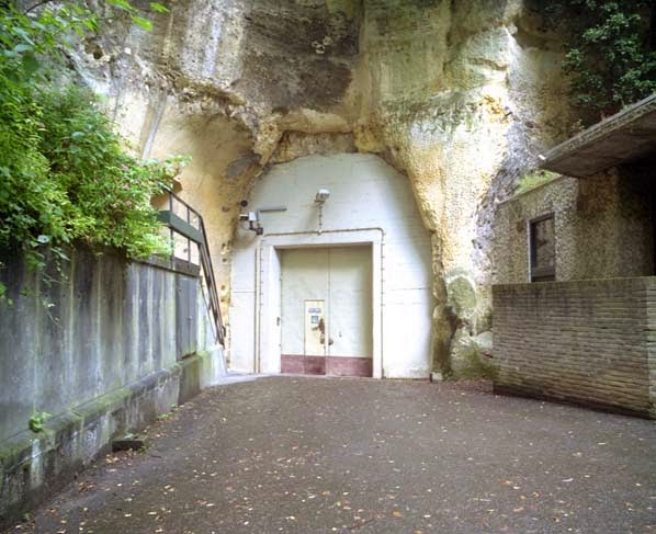
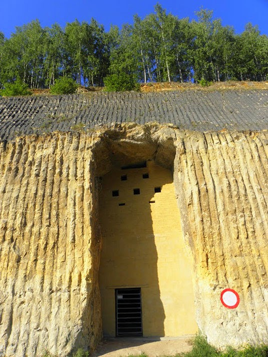
[Image: An entrance to the quarry in Kanne; photo by Nick Catford via Subterranean Britannica].

There is an underground Roman-era quarry in The Netherlands that, when you exit, you will find that you have crossed an invisible international border somewhere down there in the darkness, and that you are now stepping out into Belgium; or perhaps it’s the other way around, that there is an underground Roman-era quarry in Belgium that, when you exit, you will find that you have crossed an invisible international border somewhere down there in the darkness, and that you are now stepping out into The Netherlands.

However, this is not just a disused quarry—not just an archaeological site on the fringes of the Roman empire that was once mined for blocks of limestone. Its afterlife is by far the most interesting part of the story.

For nearly a century, beginning in the 1800s, these underground hollows were used by Jesuit monks as a secluded place for prayer, study, and meditation, and even for the carving of elaborate and impressive forms into the soft rock walls; then the Nazis took over, transforming this weird underworld into a subterranean factory for World War II airplane parts; then, finally, pushing the stakes yet higher, the whole complex of former Roman limestone mines, straddling an international border underground between two modern European nations, was turned into a doomsday bunker for NATO, a dark and mold-prone labyrinth within which military commanders constructed a Joint Operations Center for responding to the end of the world (whenever the time finally came).

[Images: Monks underground; via De Limburgse Mergelgrotten].

“There was even a 3-hole golf course complete with artificial turf,” Subterranean Britannica reports in a recent issue of their excellent magazine, Subterranea.

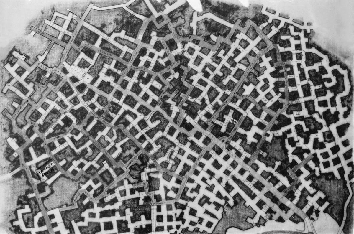
“The complex was on average 50 meters below ground covering an area of approximately 6750 acres with eight miles of corridors, 400 branches and 399 individual offices,” SubBrit explains. There were escape tunnels, as well, “one going out to the banks of the Albert Canal in Belgium, and one which came out in a farmer’s potato store in the village of Kanne.” It had its own water supply and even a dedicated wine cellar for NATO officers, who might need a glass of Europe’s finest chardonnay to help feel calm enough to launch those missiles.

Just look at this thing’s mind-boggling floor plan.

The “streets” were named, but not always easy to follow; however, this didn’t stop officers stationed there from occasionally going out to explore the older tunnels at night. A former employee named Bob Hankinson describes how he used to navigate:

Most corners were roughly 90 degrees, but only roughly. Going through the caves was an exercise in left and right turns every 50 feet or so. Navigation was helped by street names. Unlike in the USA, where streets are numbered on a sort of grid pattern, these were zigzag streets. My office on Main Street and J Street, so if I got lost I would just keep walking until I came to either Main or J, and join it. If I went the wrong way, eventually the street would peter out either at the perimeter or a T-junction, and you would just turn round and go back the other way.

As another former employee—a man named Alan Francis—explains, “If I did have spare time, I would wander through the dark tunnels where there were very few lights on at night, thinking how strange it was to be working in a Roman stone quarry.”

Writing in Subterranea, SubBrit explains that “nothing ever came out.” This was “a strict rule: apart from people, anything that went in never came out. All waste material ranging from redundant furniture to foot waste was dumped in one of the sixteen underground landfill sites” designated within this sprawling whorl of rooms and passages. Shredded documents were even mixed with water and applied directly to the walls as a kind of fibrous paste, used for insulation.

Such was the secrecy surrounding this place that it was officially classified as “a ‘forbidden place’ under the Protection of State Secrets Act which forbade people to even talk about it.”

One reason why the underground galleries are so vast, meanwhile, is apparently because of the character of the limestone they were carved through; in fact, “the limestone was so soft that the workers used a chainsaw to cut it.”

The notion that I could just cut myself a whole new room with a chainsaw—just revving this thing up and carving an entire new hallway or corridor, pushing relentlessly forward into what looks like solid earth, possibly even sawing my way into the roots of another country—is so awesome an architectural condition that I would move there tomorrow if I could.

Just imagine building this titanic doorway into the earth with a small group of friends, a case of beer, and a few chainsaws. It’s like Cappadocia by way of the Cold War. By way of Husqvarna.

[Image: An entrance into the NATO complex; via this thread].

Sadly, the whole place is contaminated with asbestos and has been badly saturated with diesel fuel. At least one environmental analysis of the underground maze found that “diesel fuel from the [copious emergency fuel] tanks had leaked into the porous limestone over a long period and had penetrated to a depth of about forty feet into the rock.”

You can imagine the weird bonfires that could have resulted should someone have been stupid enough to light a match, but “this area had to be removed and disposed of,” we read—presumably by chainsaw.

Nonetheless, today you can actually take a tour of this place—this now-derelict doomsday logistics hub that straddles international borders underground—courtesy of the Limburg Landscape Foundation.

If you can take the tour, let me know how it goes; I’d love to visit this place in person someday and would be thrilled to see any photographs.

(If you like the sound of underground NATO quarries and want to see more, don’t miss these vaguely related photo sets: NATO Quarry, N.A.T.O. Quarry, N.A.T.O. Quarry, France, Urban Explorers Discover Corroding Military Vehicles in Abandoned Subterranean Bunker, and Nato Quarry, Paris Suburbs May 2011).

Where Borders Melt

[Image: From Italian Limes. Photo by Delfino Sisto Legnani, courtesy of Folder].

One of the most interesting sites from a course I taught several years ago at Columbia—Glacier, Island, Storm—was the glacial border between Italy and Switzerland.

The border there is not, in fact, permanently determined, as it actually shifts back and forth according to the height of the glaciers.

This not only means that parts of the landscape there have shifted between nations without ever really going anywhere—a kind of ghost dance of the nation-states—but also that climate change will have a very literal effect on the size and shape of both countries.
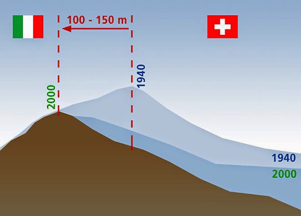
[Image: Due to glacial melt, Switzerland has actually grown in size since 1940; courtesy swisstopo].

This could result in the absurd scenario of Switzerland, for example, using its famed glacier blankets, attempting to preserve glacial mass (and thus sovereign territory), or it might even mean designing and cultivating artificial glaciers as a means of aggressively expanding national territory.

As student Marissa Looby interpreted the brief, there would be small watchtowers constructed in the Alps to act as temporary residential structures for border scientists and their surveying machines, and to function as actual physical marking systems visible for miles in the mountains, somewhere between architectural measuring stick for glacial growth and modular micro-housing.

But the very idea that a form of thermal warfare might break out between two countries—with Switzerland and Italy competitively growing and preserving glaciers under military escort high in the Alps—is a compelling (if not altogether likely) thing to consider. Similarly, the notion that techniques borrowed from landscape and architectural design could be used to actually make countries bigger—eg. through the construction of glacier-maintenance structures, ice-growing farms, or the formatting of the landscape to store seasonal accumulations of snow more effectively—is absolutely fascinating.

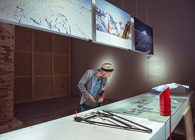
[Images: From Italian Limes. Photos by Delfino Sisto Legnani, courtesy of Folder].

I was thus interested to read about a conceptually similar but otherwise unrelated new project, a small exhibition on display at this year’s Venice Biennale called—in English, somewhat unfortunately—Italian Limes, where “Limes” is actually Latin for limits or borders (not English for a small acidic fruit). Italian Limes explores “the most remote Alpine regions, where Italy’s northern frontier drifts with glaciers.”

In effect, this is simply a project looking at this moving border region in the Alps from the standpoint of Italy.

[Image: From Italian Limes. Photo by Delfino Sisto Legnani, courtesy of Folder].

As the project description explains, “Italy is one of the rare continental countries whose entire confines are defined by precise natural borders. Mountain passes, peaks, valleys and promontories have been marked, altered, and colonized by peculiar systems of control that played a fundamental role in the definition of the modern sovereign state.”
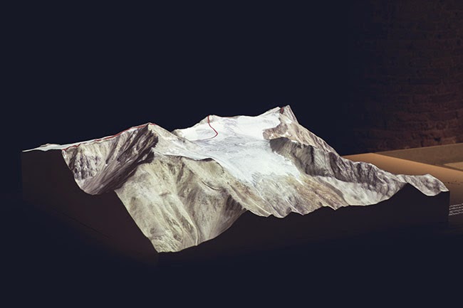
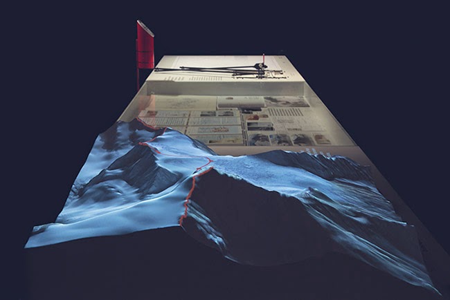
[Images: From Italian Limes. Photos by Delfino Sisto Legnani, courtesy of Folder].

However, they add, between 2008 and 2009, Italy negotiated “a new definition of the frontiers with Austria, France and Switzerland.”

Due to global warming and and shrinking Alpine glaciers, the watershed—which determines large stretches of the borders between these countries—has shifted consistently. A new concept of movable border has thus been introduced into national legislation, recognizing the volatility of any watershed geography through regular alterations of the physical benchmarks that determine the exact frontier.
[Images: From Italian Limes. Photos by Delfino Sisto Legnani, courtesy of Folder].

The actual project that resulted from this falls somewhere between landscape surveying and technical invention—and is a pretty awesome example of where territorial management, technological databases, and national archives all intersect:

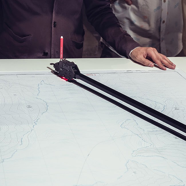
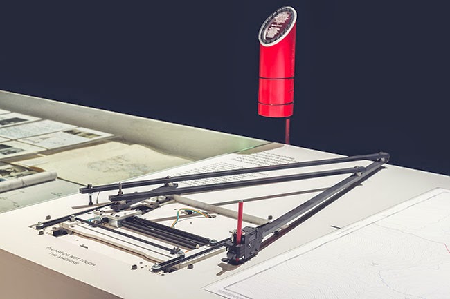
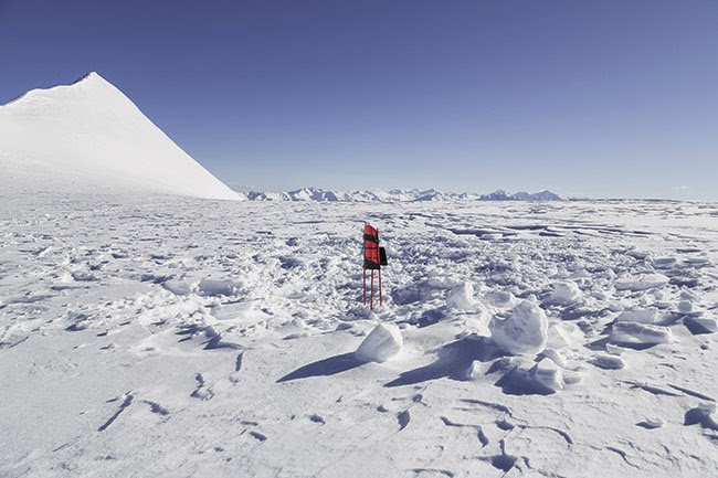
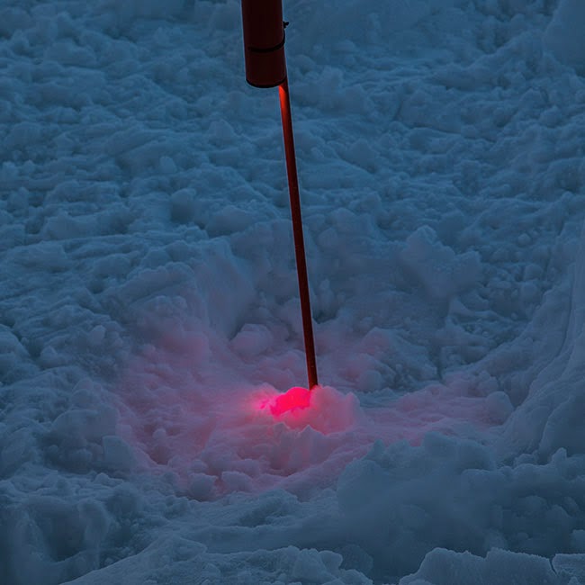
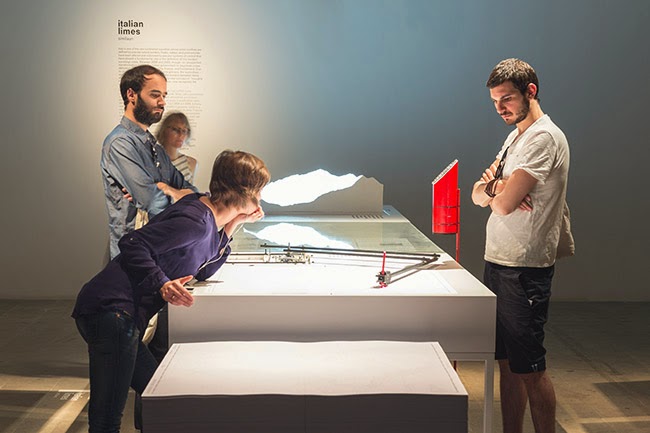
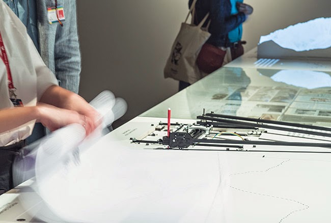
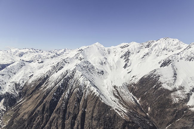
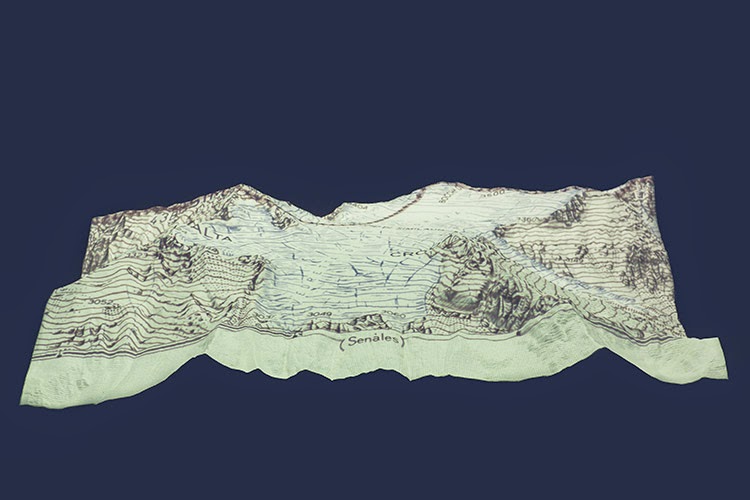
On May 4th, 2014, the Italian Limes team installed a network of solar-powered GPS units on the surface of the Similaun glacier, following a 1-km-long section of the border between Italy and Austria, in order to monitor the movements of the ice sheet throughout the duration of the exhibition at the Corderie dell’Arsenale. The geographic coordinates collected by the sensors are broadcasted and stored every hour on a remote server via a satellite connection. An automated drawing machine—controlled by an Arduino board and programmed with Processing—has been specifically designed to translated the coordinates received from the sensors into a real-time representation of the shifts in the border. The drawing machine operates automatically and can be activated on request by every visitor, who can collect a customized and unique map of the border between Italy and Austria, produced on the exact moment of his [or her] visit to the exhibition.

The drawing machine, together with the altered maps and images it produces, are thus meant to reveal “how the Alps have been a constant laboratory for technological experimentation, and how the border is a compex system in evolution, whose physical manifestation coincides with the terms of its representation.”

The digital broadcast stations mounted along the border region are not entirely unlike Switzerland’s own topographic markers, over 7,000 “small historical monuments” that mark the edge of the country’s own legal districts, and also comparable to the pillars or obelisks that mark parts of the U.S./Mexico border. Which is not surprising: mapping and measuring border is always a tricky thing, and leaving physical objects behind to mark the route is simply one of the most obvious techniques.

As the next sequence of images shows, these antenna-like sentinels stand alone in the middle of vast ice fields, silently recording the size and shape of a nation.
[Images: From Italian Limes. Photos by Delfino Sisto Legnani, courtesy of Folder].

The project, including topographic models, photographs, and examples of the drawing machine network, will be on display in the Italian Pavilion of the Venice Biennale until November 23, 2014. Check out their website for more.

Meanwhile, the research and writing that went into Glacier, Island, Storm remains both interesting and relevant today, if you’re looking for something to click through. Start here, here, or even here.
[Image: From Italian Limes. Photo by Delfino Sisto Legnani, courtesy of Folder].

Italian Limes is a project by Folder (Marco Ferrari, Elisa Pasqual) with Pietro Leoni (interaction design), Delfino Sisto Legnani (photography), Dawid Górny, Alex Rothera, Angelo Semeraro (projection mapping), Claudia Mainardi, Alessandro Mason (team).

A Building For Measuring Borders

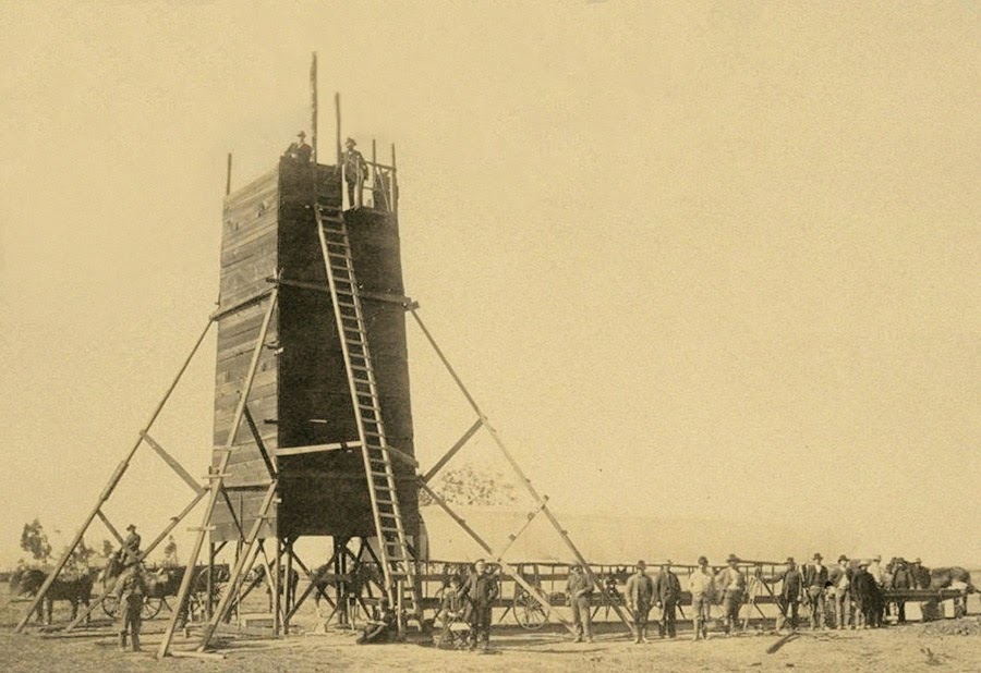
The so-called “Yolo Buggy” was not a 19th-century adventure tourism vehicle for those of us who only live once; it was a mobile building, field shelter, and geopolitical laboratory for measuring the borders of an American county. Yolo County, California.
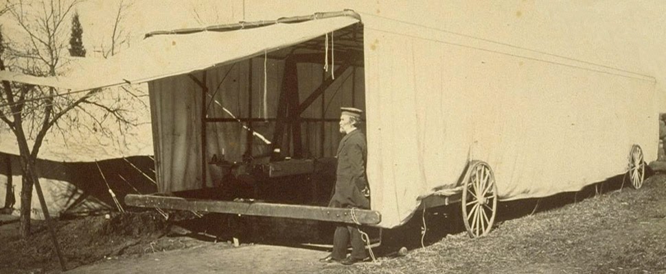
The “moveable tent or ‘Yolo Buggy,'” as the libraries at UC Berkeley describe it, helped teams of state surveyors perform acts of measurement across the landscape in order to mathematically understand—and, thus, to tax, police, and regulate—the western terrain of the United States. It was a kind of Borgesian parade, a carnival of instruments on the move.

The resulting “Yolo Baseline” and the geometries that emerged from it allowed these teams to establish a constant point of cartographic reference for future mapping expeditions and charts. In effect, it was an invisible line across the landscape that they tried to make governmentally real by leaving small markers in their wake. (Read more about meridians and baselines over at the Center for Land Use Interpretation).
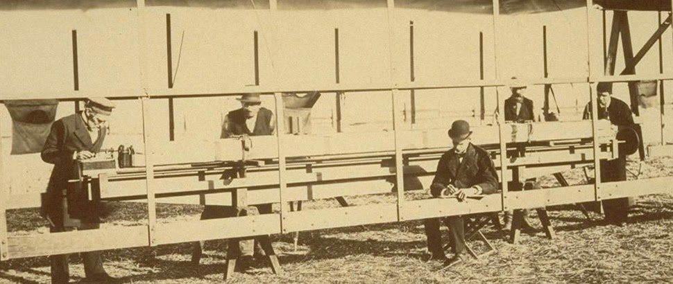
In the process, these teams carried architecture along with them in the form of the “moveable tent” seen here—which was simultaneously a room in which they could stay out of the sun and a pop-up work station for making sense of the earth’s surface—and the related tower visible in the opening image.
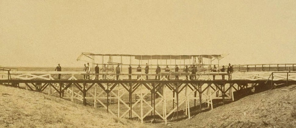
That control tower allowed the teams’ literal supervisors to look back at where they’d come from and to scan much further ahead, at whatever future calculations of the grid they might be able to map in the days to come. You could say that it was mobile optical infrastructure for gaining administrative control of new land.
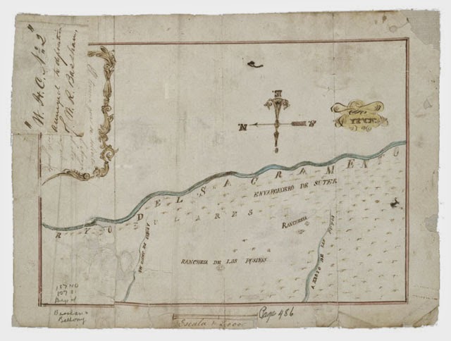
Like a dust-covered Tron of the desert, surrounded by the invisible mathematics of a grid that had yet to be realized, these over-dressed gentlemen of another century helped give rise to an abstract model of the state. Their comparatively minor work thus contributed to a virtual database of points and coordinates, something immaterial and totally out of scale with the bruised shins and splintered fingers associated with moving this wooden behemoth across the California hills.

(All images courtesy UC Berkeley/Calisphere).