1) A short piece in The Scientist profiles artist Macoto Murayama, who “began applying the computer graphics programs and techniques he had learned while studying architecture at Miyagi University of Education in Sendai to illustrate, in meticulous detail, the anatomy of flowers.”
Murayama physically dissects flowers in his studio, uncovering what he calls their “hidden mechanical and inorganic elements”; he then “sketches what he sees, photographs it, and models it on the computer using 3dsMAX software, a program typically used by architects and animators. Finally, he creates a composition of the different parts in Photoshop, and uses Illustrator to add measurements and other labels.” See more at The Scientist.
2) Archaeologists in Israel have used pollen trapped in plaster to reconstruct a “luxurious garden created by the Persians.” Their method reads like a rejected pitch for Jurassic Park 4: “Using a specialised technique for separating fossilized pollen trapped in the layers of plaster found in the garden’s waterways, researchers from Tel Aviv University’s Sonia and Marco Nadler Institute of Archaeology have now been able to identify exactly what grew in the ancient royal gardens of Ramat Rahel. By examining the archaeological evidence and the likely settings of specific plants they have also been able to reconstruct the lay-out of the garden.”
The hydrologically complex landscape, as reimagined by the archaeologists, was able to support a huge variety of species, including “ornamentals such as myrtle and water lilies, native fruit trees including the grape vine, the common fig, and the olive and imported citron, Persian walnut, cedar of Lebanon and birch trees. Researchers theorize that these exotics were imported by the ruling Persian authorities from remote parts of the empire to flaunt the power of their imperial administration.”
It would be interesting to reconstruct Central Park based solely on pollen grains trapped inside the painted walls and debris-filled lobbies of ruined hotels of a semi-submerged New York City 2,000 years from now. A Nobel Prize in Landscape Forensics.
Alongside The Dam Busters and The Wooden Horse, The Great Escape was shown on British TV at least once a month when I was growing up. It is such familiar, comforting fare that, in a 2006 poll, Britons voted The Great Escape their third choice for a film worth watching on Christmas Day (It’s A Wonderful Life and The Wizard of Oz were first and second choice, respectively).
A large part of its appeal, at least for me, lies in the Boy’s Own adventure-style spirit and Heath Robinson-esque ingenuity of the Allied POWs.
The movie begins with the most experienced and determined Allied escapologists arriving at the newly constructed, supposedly escape-proof Stalag Luft III. Its resistance to casual, opportunistic break outs is demonstrated in the first few minutes, as POWs unsuccessfully attempt to slip out hidden under tree branches, disguised as Russian laborers, and in the blind spots of the guard towers.
An altogether more rigorous approach is required, and, under the direction of Richard Attenborough’s Squadron Leader Bartlett, the entire camp is organized into a tunnel-digging machine, with a strict division of labor, assembly-line document- and clothing-production techniques, and a suite of redundant underground infrastructure (tunnels “Tom,” “Dick,” and the ultimately successful “Harry”).
As in A Man Escaped, breaking out requires “the strategic dismantling and reassembly of all designed objects that aren’t architecture”: powdered milk cans, socks, and bunk bed slats are transformed into tunnel ventilation pumps, supports, and trouser-mounted soil disposal devices.
And, as in Grand Illusion, there is a distinct sense that tunneling is a codified sport, bound to be played in prison camps. Certainly, the Allied POWs seem to be motivated as much by a boyish delight in outwitting the Germans through their own ingenuity and teamwork as by a sense of duty or passionate desire to return home. Stalag Luft III, in this view, is something like a game level, challenging seasoned players to apply their existing tunneling techniques in innovative new ways. (Intriguingly, the camp was used as the basis for Dulag IIIA in the first installment of Call of Duty).
If the design of prison camps and the sport of tunneling have co-evolved from World War I’s Grand Illusion to World War II’s Great Escape, then so, too, has the theater of war, from the defined battlefield of the trenches to a total war embedded into and dispersed throughout civilian landscapes.
The second half of The Great Escape, following the trajectories of those who successfully tunneled out of Stalag Luft III, reveals that, in fact, most of the European continent is a prison camp of sorts, booby-trapped with English-speaking Gestapo, and with its safe havens (Switzerland and Spain) ring-fenced with barbed wire and mountain ranges.
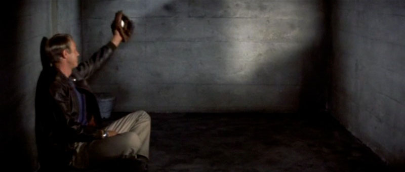
Finally, Steve McQueen, the “Cooler King,” provides future generations of filmmakers with an iconic image of the spatial and temporal experience of solitary confinement: a rubber ball, repetitively bounced off cell walls as if both defining and testing the limits those walls pose to free motion. From The Shining to The Simpsons to Ryan Reynolds in Safe House, the endlessly bouncing ball has since become visual shorthand, indicating that a character is trapped, whether their prison is mental, physical, or both.
In a fascinating detail from a long series of articles published two years ago in the Washington Post, recently expanded as a stand-alone book called Top Secret America, we learn about one way to hide classified government infrastructure in plain sight.
“[J]ust outside Washington,” authors Dana Priest and William Arkin explain, in the exurbs of depopulated office parks and “huge buildings with row after row of opaque, blast-resistant windows,” there can be found what the authors describe as “the capital of an alternative geography of the United States, one defined by the concentration of top-secret government organizations and the companies that do work for them.”
One such complex, called Fort Meade, “is the largest of a dozen such clusters across the United States.”
And it is cleverly camouflaged:
The existence of these clusters is so little known that most people don’t realize when they’re nearing the epicenter of Fort Meade’s, even when the GPS on their car dashboard suddenly begins giving incorrect directions, trapping the driver in a series of U-turns, because the government is jamming all nearby signals.
It’s an experiential trap street—an infinite loop—a deliberate cartographic error introduced into the mapping of the world so as to sow detour and digression. A kind of digital baffling, or recursive geography as state defensive tactic.
I’m also curious when we might see this privatized and domesticated—gated communities, for instance, blocking the GPS navigation of their streets in the misguided belief that this will help protect them from future burglary, effectively delisting themselves from public cartographic records. Perhaps the future of neighborhood security lies in the privatized repurposing of advanced signal-jamming technology, the misleading lamination of other, false maps onto the streets as they really exist.
I’ve been going through a lot of old files recently, including a short piece I clipped from New Scientist five years ago. I absolutely love stories like this, and I swoon a little bit when I read them; it turns out that “plants growing over old sites of human habitation have a different chemistry from their neighbors, and these differences can reveal the location of buried ruins.”
The brief article goes on to tell the story of two archaeologists, who, in collecting plants in Greenland, made the chemical discovery: “Some of their samples were unusually rich in nitrogen-15, and subsequent digs revealed that these plants had been growing above long-abandoned Norse farmsteads.”
The idea that your garden could be more like an indicator landscape for lost archaeological sites—that, below the flowers, informing their very chemistry, perhaps even subtly altering their shapes and colors, are the traces of abandoned architecture—is absolutely unbelievable.
[Images: More extraordinary photogravures by Karl Blossfeldt].
So why not develop a new type of flower in some gene lab somewhere, a designed species that reacts spectacularly to the elevated presence of nitrogen-15 from ruined settlements? Ruin Flowers® by Monsanto acting as deserted medieval village detection-landscapes, as thale cress does for mines.
You plant these flowers or trees or vineyards—future archaeological wine—and you wait three seasons for the traces to develop. Now imagine a modified tree that can only grow directly above ruined houses. Imagine an entire forest of these trees, curling and knurled to form floorplans, shaping out streets and alleyways, rooms instead of orchards and halls instead of groves. Now imagine the city beneath that forest becoming visible as the woods slowly spread, articulating whole lost neighborhoods over time.
Genetically-modified plantlife used as non-invasive archaeological research tools would, at the very least, add a strange practicality to summer gardening activities, in the process turning whole surface landscapes into an unexpected new kind of data visualization program.
It’s the earth’s surface as browser for what waits undetected below.
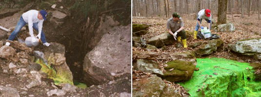
Toxic chemicals leaking from an old wastewater treatment plant in Alabama have unexpectedly led to the discovery of a 1,700-year old “pre-historic village” buried in the ground nearby. Chemicals “have seeped into the ground surrounding the old plant,” according to a local news station, so “the soil needs to be removed and taken to a toxic waste facility.”
However, a survey of the contaminated site soon revealed that the ground also contained extremely well-preserved artifacts “from a village that once thrived” there. “Lo and behold,” the head excavator remarked to the news show: “we found a massive late-middle Woodland period village.”
It’s not hard to imagine someone another 1,700 years from now accidentally discovering the forgotten city of, say, New York—or Chicago, or Bangkok, swallowed by mud—after a chemical leak at a nearby factory: radioactive liquids drain down through the topsoil, flowing around buried walls and ruins, forming iridescent pools on floors in basements—slow and toxic streams tracing the shapes of old stairways, lighting a path for future excavation and descent. Like giving the earth a radiopharmaceutical, you fire up a ground-scanning machine, trace the pollution underground, and, lo and behold, the dark outlines of buried cities start to glow.
[Images: Dye-tracing cave systems; note that the chemical used is supposedly non-toxic].
In fact, I’m reminded of dye-tracing techniques used for mapping otherwise impenetrable or overly complex cave systems. In James Tabor’s wildly uneven 2010 book Blind Descent, for instance, we read about legendary caver Alexander Klimchouk, who set about dye-tracing caves on the Arabika Massif, including Krubera Cave, currently the deepest known cave in the world.
“In 1984 and 1985,” Tabor explains, “[Klimchouk] poured fluorescein dye into several caves, including Krubera, high on the Arabika. Traces of that dye later flowed out of springs on the shore of the Black Sea far below. More traces tinged the water 400 feet beneath the surface of the Black Sea, miles offshore,” indicating genuinely—in fact, record-breakingly—huge dimensions for the overall system of caves.
[Images: Dye-tracing caves].
But even the most remote, fictional possibility that future spelunking archaeologists might someday map lost cities—London, Moscow, Beijing, Rome—by using dye-tracing packs to illuminate that underground world of collapsed halls and buried rooms is extraordinary. Cartographers in mountaineering gear and helmet-mounted floodlights descend into the New York subway system in 5,161 A.D., following luminescent trails of fluorescein dye, crawling, walking, rappelling into the underworld on the trail of shining rivers as subterranean ruins begin to shine.
The other day I mentioned a poem by John Balaban, taken from his book Locusts at the Edge of Summer; but there’s another poem in that book with an incredible image that seems worth posting here.
In it, Balaban describes how villagers growing rice during the Vietnam War—where Balaban, a conscientious objector, served with the International Volunteer Corps—stumble upon an extraordinary feature in the landscape:
Beyond the last treeline on the horizon beyond the coconut palms and eucalyptus out in the moon-zone puckered by bombs the dead earth where no one ventures, the boys found it, foolish boys riding buffaloes in craterlands where at night bombs thump and ghosts howl. A green patch on the raw earth.
This “green patch” has an usual shape, however. Balaban continues:
In that dead place the weeds had formed a man where someone died and fertilized the earth, with flesh and blood, with tears, with longing for loved ones. No scrap remained; not even a buckle survived the monsoons, just a green creature, a viny man, supine, with posies for eyes, butterflies for buttons, a lily for a tongue.
And the sight of this “green creature” proves too fertile, unforgettable, haunting all the villagers who’ve seen it:
Now when huddled asleep together the farmers hear a rustly footfall as the leaf-man rises and stumbles to them.
Out of the darkness, convinced by the life they give to the land around them that they might not yet be dead, the missing-in-action pull themselves from the tangle of the earth and rise and walk again.
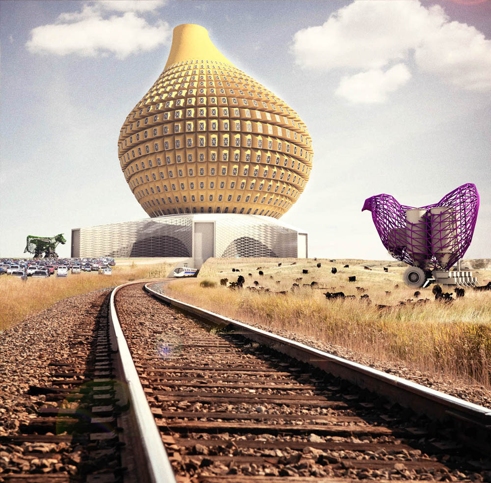
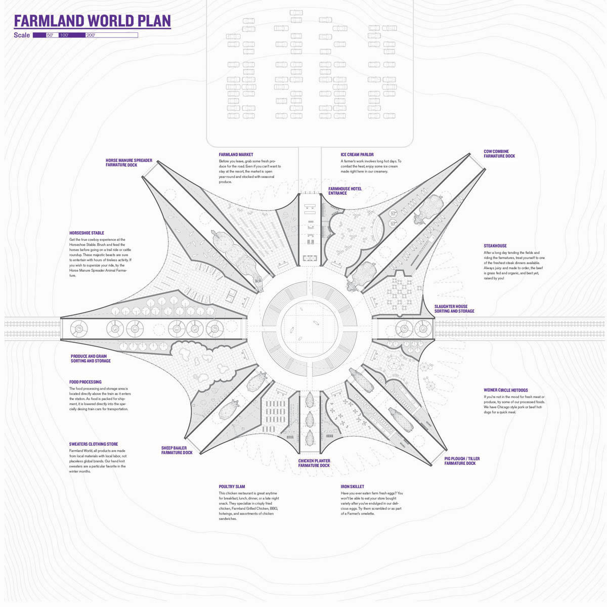
[Image: “Farmland World” by Design With Company (Allison Newmeyer and Stewart Hicks)].
One of the runners-up for the recent Animal Architecture Awards is also one of my favorites from the competition: “Farmland World” by Allison Newmeyer and Stewart Hicks of the Chicago-based Design With Company.
The project is an ironic investigation of how humans relate to farm animals—more specifically, how the ongoing spatial separation between humans and the animals they rely on for food and other forms of agricultural work can make animals seem to be nothing more than utilitarian machines.
The everyday life of the average American is almost completely disconnected from the land and animals that support them. Even farmers perform their duties primarily through automated mechanisms that remove them from the subject of their industry. The constructed distance between the human “us” and the animal “others” is increasing to the point that distinctions between machines and animals look blurry purely from distanced detachment. From our removed perspective, the extreme demand for cheap food production and the diversion of the pet economy distorts animals until they look more like utilitarian machines (bacon) or anthropomorphic projections to entertain and decorate (tea-cup terrier). As we relate to animals and machines similarly, where each begins to exhibit characteristics of the other, their converging trajectories point to an impending crisis at their collision.
Farmland World makes the human-animal encounter spectacular, proposing an absurdly over-the-top farm animal theme park—a “human/machine/animal hybrid adventure-land.”
Farmland World “is a chain of agro-tourist resorts sprinkled across the American Midwestern countryside”:
Part theme park and part working farm, guests arrive to the resort via train and stay as part of 1-day, 3-day or 5-day experience packages. Capitalizing on both recent governmental investments in high-speed rail infrastructure and the plentiful subsidies for farming, the network of resorts combine crowd-sourced farm labor with eco-tainment.
“As train-loads of itinerant fantasy farmers arrive,” Newmeyer and Hicks drily write, “they are herded to the Grazing Coliseum to receive their complimentary overalls. From there, the adventure begins.”
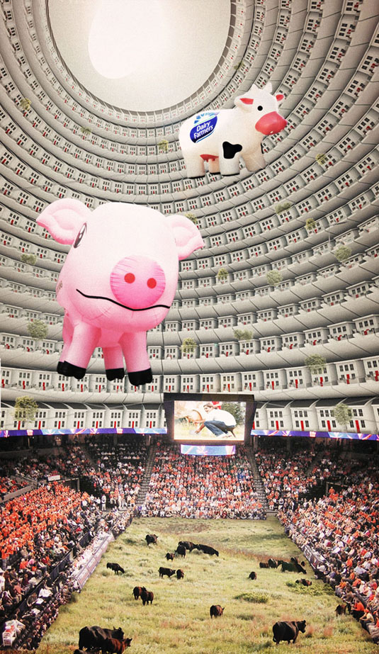
Foregrounding the idea that humans have increasingly come to confuse animals with machines, Farmland World is populated by robots, rides, and representations.
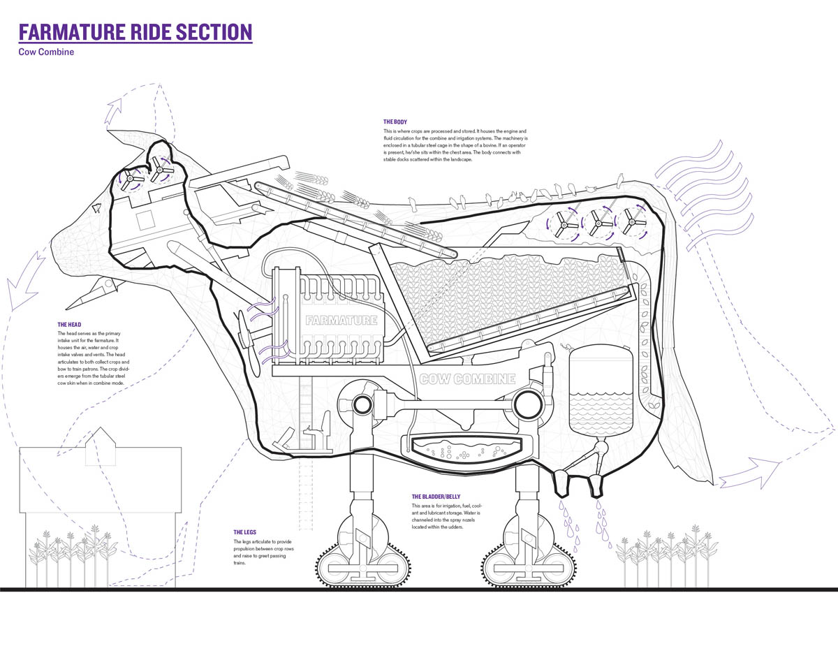
Inflatable mega-pigs and hollow, roving “cow combines” act as “robotic performers,” in the designers’ words. Animal replicants, these false creatures “extend the tradition of machines using and mimicking animals for moving, operating, branding and processing food crops.”
Meanwhile, the architect adds, “temporary farm excursionists”—paying visitors—”work, sowing and harvesting fields, becoming part of the herd. Farmland World embraces this hybrid human-animal-machine relationship, reinvigorating the rural landscape.”
[Images: The robotic super-cows of “Farmland World” by Design With Company; view section in more detail].
As you can see in the project’s overall guide, there are a whole series of these giant robot animals. A “chicken planter” stands beside a mechanical “sheep baaaler,” which, in turn, is neighbors with a pig plow and a mechanical horse that spreads real horse manure from its techno-derriere. Think of it as Westworld in an age of vast industrial farming—a livestock Disneyland.
On the project plan, you’ll also see such places as “Beeville” and “Veggie Row,” the latter promising an internally-animated range of machine-plants sprouting from beds of artificial soil.
Having gone to elementary school in a small town in rural Wisconsin, I vividly remember being taken to see farm animals over at UW-Madison, including one that had had a window surgically implanted into its side; you could actually watch the cow, in section, digesting its food.
To go from this—a bovine proto-cyborg—to Design With Company’s beautifully rendered “Farmland World” doesn’t actually seem like such a stretch.
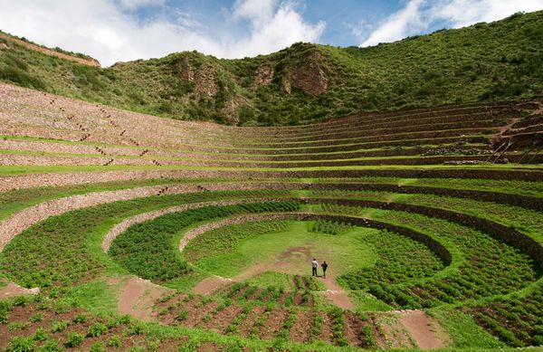
A slideshow over at National Geographic features this image by photographer Ian Wood, showing, in the magazine’s own words, “what might be called extreme Inca landscaping.”
[Image: The weather bowl at Moray, Peru; photo by Ian Wood/Alamy, courtesy of National Geographic].
“Three enormous pits, each with beautifully curved sides that staircase down like the interiors of titanic flowerpots have been carved out of the earth to depths of up to 100 feet and more,” the magazine adds. They are like Indian stepwells—only they concentrate thermal gradients—and this affects the local weather: “Air temperatures between the top and bottom layers can differ by more than 20 degrees, which has led some researchers to theorize that Moray was an Inca agricultural site where experiments on crops were conducted.”
It’s a site of experimental agriculture fueled by an act of microclimatic terrain deformation.
So does this mean that the weather at Moray should be subject not only to meteorological analysis, but to archaeological interpretation? The site you’re excavating seamlessly continues into the sky above it, turning the weather itself into an historic artifact—a whole new spin on paleotempestology.
But is the weather created by an historic site also part of that historic site? If so, should ancient microclimates such as these be subject to material preservation? Put another way, if there were a Museum of Ancient Microclimates, how would you design it and what would the visitor experience be?
Imagine a whole constellation of these oversized weather pits, meanwhile, distributed throughout the Andes, all interacting with and augmenting one another, producing continent-scale storm systems—and imagine being hit by a summer downpour, or sitting calmly throughout the winter as blizzards rage just one valley over, knowing that the atmospheric events around you are really long-lasting cultural gifts of the people who lived there centuries before. Weather designed by your ancestors still rages around you today.
Superficially, I’m reminded of the hexagonal “water storage banks” of Sietch Nevada, a speculative design by the San Francisco-based firm MATSYS. While the resemblance doesn’t go much beyond form, this comparison lets us borrow MATSYS’s idea of a water bank and, thus, reinterpret the Incan site at Moray as a kind of weather bank, storing temperatures and headwinds year round. It is a space to store climates in.
Extrapolating wildly from this, if the rise of the Himalayas radically altered the earth’s climate by changing weather patterns for thousands of miles in all directions, then perhaps we can imagine a scenario in which a network of artificial pits in the Andes begins to affect the jet stream, plunging Australia into drought and pushing rain far north into Mexico—and that, in turns out, is those pits’ very purpose, having been excavated by scientifically advanced, self-styled weather warriors more than 600 years ago for reasons still unclear today. Groups of elders would get together in the dark, sitting around their pits in tight circles as the winds picked up, burning incense, singing tales, hurling storms like artillery into the central Pacific.
1)Arup Foresight and the Bartlett School of Architecture have teamed up to gather what they call “responses to some of the world’s most pressing issues as featured in the publication, Drivers of Change. We would like you to tell us your Stories of Change.” Original films, texts, and architectural designs are all eligible and welcome; the texts could even “be a poem, a letter, a blog-post, even a currated collection of tweets.” Which is good news, but the deadline is approaching quickly: Friday, 24 June 2011. See the Stories of Change website for more.
2) For its new call for papers, the Bauhaus-Universität’s Horizonte journal begins by quoting architect Raimund Abraham: “From earliest times,” Abraham writes, “architecture has complied with that order of logical forms which is contained in the nature of each material. That is to say: each material can only be used within the limits imposed by its organic and technical possibilities.” This fourth issue of the consistently well-designed journal explores the materiality of building: the issue thus “challenges the constraints and possibilities of architectural production, in order to reflect on the material and constructive methodologies of the present day.” I imagine essays and even speculative fiction covering everything from genetically engineered building materials to 3D printers—to new types of brick to artisanal craftwork—would be of interest. Your deadline is 8 July 2011.
3) The Architectural League wants to give New York the Greatest Grid:
On the occasion of the two hundredth anniversary of the 1811 Commissioners’ Plan for New York, the foundational document that established the Manhattan street plan from Houston Street to 155th Street, the Architectural League invites architects, landscape architects, urban designers, and other design professionals to use the Manhattan street grid as a catalyst for thinking about the present and future of New York. For two centuries, the Manhattan street grid has demonstrated an astonishing flexibility to accommodate the architectural gestures and urban planning theories of successive generations of architects, urban designers, private developers, and city officials. Given its capacity for reinvention, how might the Manhattan grid continue to adapt and respond to the challenges and opportunities—both large and small—that New York faces now and into the future?
Your deadline is 26 September 2011; see the competition website for much more information.
4) A new Advanced Architecture Contest has been announced, sponsored by the Institute for Advanced Architecture and Hewlett Packard. The theme this year is “CITY-SENSE: Shaping our environment with real-time data.” Aim to submit “a proposal capable of responding to emerging challenges in areas such as ecology, information technology, architecture, and urban planning, with the purpose of balancing the impact real-time data collection might have on sensor-driven cities.” Read more at the Advanced Architecture Contest website; the deadline is 26 September 2011.
5) The California Architectural Foundation, in partnership with the Arid Lands Institute and the Academy for Emerging Professionals, has launched what it calls “an open ideas competition for retrofitting the American West.” The Drylands Competition seeks new ways of “anticipating, mitigating, and adapting to projected impacts of climate change” and other “critical challenges” facing the region. These challenges include water scarcity, obsolete infrastructure, and even the growing gap between scientific knowledge and public policy. “Design teams are invited to generate progressive proposals that suggest to policy makers and the public creative alternatives for the American west, ideas that may be replicated throughout the world.” Register by 15 November 2011; see their website for much more info.
6) Meanwhile, across the pond, the Architects Journal is seeking essays of up to 1,500 words, by writers under the age of 35, for their £1,000 AJ Writing Prize (the money will be split amongst all winners). The jury consists of Christine Murray, Alan Berman, Joseph Rykwert, and Mary Banham; you only have until 30 June 2011 to participate, so get cracking.
7) Finally, this one doesn’t open till September 2011, but it sounds fascinating. Sponsored by Architecture for Humanity, [un]restricted access is “a design competition that will re-envision the future of decommissioned military space. This is an open invite to the global design and construction community to identify retired military installations in their own backyard, to collaborate with local stakeholders, and to reclaim these spaces for social, economic, and environmental good.” As I say, thought, it doesn’t launch until September, but keep your eyes on the [un]restricted access website for emerging info.
I’m heading off soon on a road trip with Nicola Twilley, from Edible Geography, to visit some incredible sites (and sights) around the desert southwest, visiting places where architecture, astronomy, and the planetary sciences, to varying degrees, overlap.
[Image: The “Electric Aurora,” from Specimens of Unnatural History, by Liam Young].
The ulterior motive behind the trip—a kind of text-based, desert variation on Christian Houge’s study of instrumentation complexes in the Arctic—is to finish up my curator’s essay for the forthcoming Landscape Futures book.
Finally, Nicola and I will fall out of the car in a state of semi-delirium in La Jolla, California, where I’ll be presenting at a 2-day symposium on Designing Geopolitics, “an interdisciplinary symposium on computational jurisdictions, emergent governance, public ecologies,” organized by Benjamin Bratton, Daniel Rehn, and Tara Zepel.
That will be free and open to the public, for anyone in the San Diego area who might want to stop by, and it will also be streamed online in its entirety; the full schedule is available at the Designing Geopolitics site.
From Border Town, an independent research and design workshop to be held in Toronto this summer, from 16 June-18 August, now seeking applications:
Your farm is completely surrounded by a foreign country because the king lost it in a game of cards. You live in Cooch Behar.
You are eating at a café when you are informed that it must close. If you’ll just shift to a table in the other country, service is still available. This café is in Baarle/Hertog.
You work in the mayor’s office. Down the hall is a parallel mayor’s office with a whole mirror set of city officials to govern the other half of your city. You work in Texarkana.
We believe that a great deal can be learned by investigating the strange edge cases of the world. Border towns are the extreme edge of where geography and politics collide. They throw the abstractions of governance into sharp physical relief. They are a fertile site for investigation into questions of security, freedom, architecture, immigration, trade, smuggling, sovereignty, and identity.
Border Town is a 10-week, multi-participant collaborative design studio that will investigate the conditions that surround life in cities situated on borders, divided by borders, or located in conflict zones. By investigating these strange specimens of political geography, we can being to think and design about the interaction of legal and physical architecture and how these forces shape the built environment and the lives of the people living in it.
The workshop is organized by Tim Maly and Emily Horne, and applications are due by 2 June.
In any case, Border Town promises to be an interesting experience for all involved—and I should add that it’s great to see people putting together this kind of independent educational workshop outside of the university system. If you end up being one of the participants, I’d love to hear how it goes.

 [Image: A flower by Macoto Murayama, via The Scientist].
 [Image:
 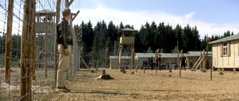 [Image: From
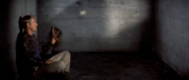
 [Images: From
 [Image: Photo by
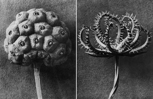 [Images: Botanical photogravures by
 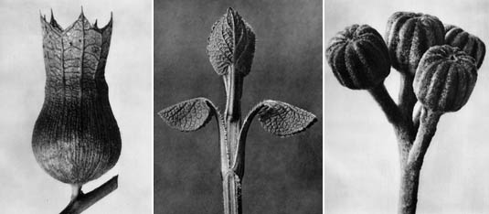 [Images: More extraordinary photogravures by
 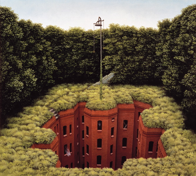 [Image:
 [Images: Dye-tracing cave systems; note that the chemical used is supposedly non-toxic].
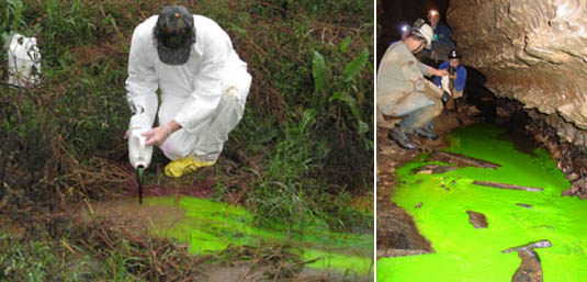 [Images: Dye-tracing caves].
 [Image: An unrelated photo by BLDGBLOG].
 [Image: “
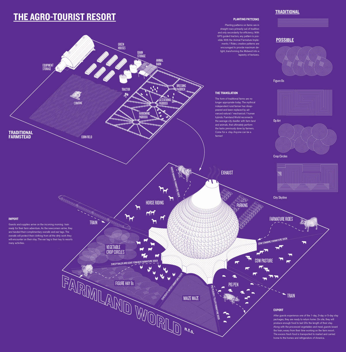 [Image: From “
 [Image: From “
 [Image: From “
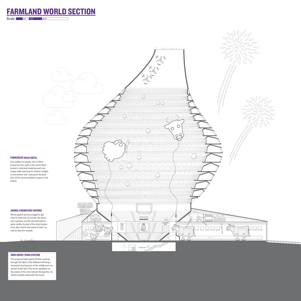
 [Image: From “
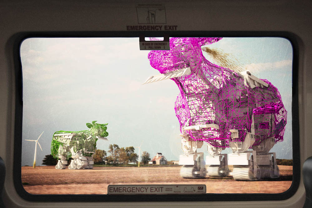
 [Images: The robotic super-cows of “
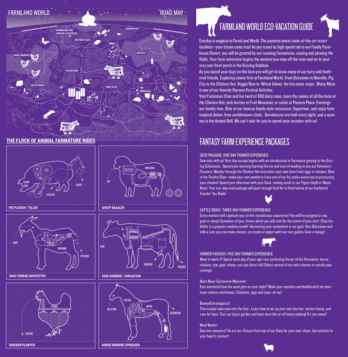 [Image: From “
 [Image: The weather bowl at Moray, Peru; photo by Ian Wood/Alamy, courtesy of
 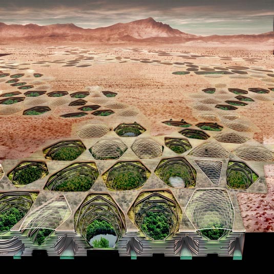 [Image: From
 [Image: “
 2) For its new
  3) The Architectural League wants to give New York the
  4) A new
  5) The California Architectural Foundation, in partnership with the
 [Image: The
  [Image: The “Electric Aurora,” from Specimens of Unnatural History, by
 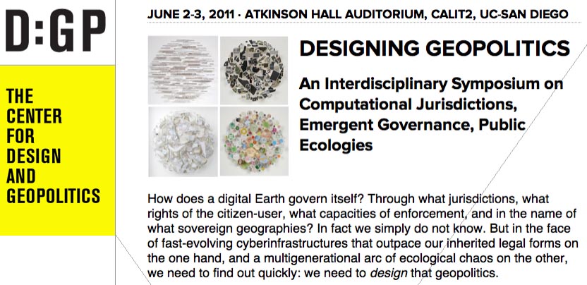 Finally, Nicola and I will fall out of the car in a state of semi-delirium in La Jolla, California, where I’ll be presenting at a 2-day symposium on
 [Image: Photo by