Warnings Along the Inundation Line

[Image: Cover from An Incomplete Atlas of Stones by Elise Hunchuck].

After the Tōhoku tsunami in 2011, one of the most ominous details revealed about the coast where it struck, for those of us not familiar with the region, was that a series of warning stones stand there overlooking the sea, carved with sayings such as, “Do not build your homes below this point!

As part of her recent thesis at the Daniels Faculty of Architecture, Landscape, and Design—a school of the University of Toronto—landscape architect Elise Hunchuck spent the summer of 2015 traveling around Japan’s Sanriku coast, documenting every available tsunami stone in photographs, maps, and satellite views, and accumulating seismic and geological data about each stone’s local circumstances.

The end result was a book called An Incomplete Atlas of Stones. It was inspired, she writes, by “a combined interest in warning systems and cartography.”

[Image: From An Incomplete Atlas of Stones by Elise Hunchuck].

“Rising from the earth,” Hunchuck writes in the book’s introduction, “many [of the warning stones] were placed in the landscape to mark either the height of the inundation line or to mark territory above the inundation line.”

They formed a kind of worst-case boundary line for where solid land meets the sea, the known limit of catastrophic inundation.

[Images: Spreads from An Incomplete Atlas of Stones by Elise Hunchuck].

The book introduces each stone taxonomically:

Each tsunami stone is introduced by its geographic coordinates: latitude, longitude, and elevation. Latitude and longitude site each stone on the surface of the earth while elevation situates each stone in relation to the mean level of the sea. The stones are further situated; first, by the boundaries of the village, town, or city they are located within; second, by their administrative prefecture; and, third, their geographical region. As each stone has been erected in response to a major tsunami, both the year and name of the tsunami is listed in addition to the stone’s relation to the inundation line (below the line, on the line, or above the line) of both its target tsunami and the tsunami of 2011. Each stone, at the time of its erection, was engraved with a message. The stones mapped in this atlas may be considered as belonging to one of two categories: as a memorial, commemorating people and places lost to an earthquake tsunami, or as a lesson, providing a description of events and directions as to where to build, where to evacuate to, and where waters have risen in the past.

Each stone or set of stones thus gets a four-page spread, giving the book a nice structural consistency.

[Images: Spreads from An Incomplete Atlas of Stones by Elise Hunchuck].

As you can also see, satellite shots are used to show the landscape at different states in time: one depicts the coastline immediately following the 2011 tsunami, the next then showing the same locatio after up to five years of rebuilding have taken place.

In some of these comparisons, seemingly nothing at all has changed; in others, it appears nearly the entire landscape has been consumed by forests.

[Images: Spreads from An Incomplete Atlas of Stones by Elise Hunchuck].

The entire book is nearly 250 pages in length, and the selections I’ve chosen here barely scratch the surface. The material Hunchuck has gathered would not only be served well by a gallery installation; the project also sets up an interesting formal precedent for other documentary undertakings such as this.

Given my own background, meanwhile—I am a writer, not an architect—I would love to see more of a reporting angle in future versions of this sort of thing, e.g. interviews with local residents, or even with disaster-response workers, connected to these landscapes through personal circumstance.

The narratives of what these stones are and what they mean would be well-illustrated by more than just data, in other words, including verbal expressions of how and why these warnings were heeded (or, for that matter, fatally overlooked).

[Images: Spreads from An Incomplete Atlas of Stones by Elise Hunchuck].

In any case, the title of Hunchuck’s book—it is an incomplete atlas—also reveals that Hunchuck is still investigating what the stones might mean and how, as a landscape architect, she might respond to them. Her goal, she writes, “is not to offer an explicit response—yet. This incomplete atlas shares the stories of seventy five places, each without a definitive beginning or end.”

Along those lines, I’m reminded of a geologist quoted by the New York Times in their own coverage of the megaliths: “We need a modern version of the tsunami stones.”

Stay tuned for Hunchuck’s forthcoming website with more about the project.

(Vaguely related: Boundary Stones and Capital Magic and, to a certain extent, Watermarks.)

Voids and Vacuums

[Image: Google Maps view of Mosul Dam (bottom center) and the huge reservoir it creates].

Dexter Filkins—author of, among other things, The Forever War—has a long new piece in the first 2017 issue of The New Yorker about the impending collapse of Iraq’s Mosul Dam.

The scale of the potential disaster is mind-boggling.

If the dam ruptured, it would likely cause a catastrophe of Biblical proportions, loosing a wave as high as a hundred feet that would roll down the Tigris, swallowing everything in its path for more than a hundred miles. Large parts of Mosul would be submerged in less than three hours. Along the riverbanks, towns and cities containing the heart of Iraq’s population would be flooded; in four days, a wave as high as sixteen feet would crash into Baghdad, a city of six million people. “If there is a breach in the dam, there will be no warning,” Alwash said. “It’s a nuclear bomb with an unpredictable fuse.”

Indeed, “hundreds of thousands of people could be killed,” according to a UN report cited by Filkins.

What’s interesting from a technical perspective is why the dam is so likely to collapse. It’s a question of foundations. The dam was built, Filkins writes, on rock “interspersed with gypsum—which dissolves in contact with water. Dams built on this kind of rock are subject to a phenomenon called karstification, in which the foundation becomes shot through with voids and vacuums.”

Filling those voids with grout is now a constant job, requiring dam engineers to pump huge amounts of cementitious slurry down into the porous rock in order to replace the dissolved gypsum.

[Image: Mosul Dam spillway; photo by U.S. Army Staff Sgt. Brendan Stephens].

At one point, Filkins goes inside the dam where “engineers are engaged in what amounts to an endless struggle against nature. Using antiquated pumps as large as truck engines, they drive enormous quantities of liquid cement into the earth. Since the dam opened, in 1984, engineers working in the gallery have pumped close to a hundred thousand tons of grout—an average of ten tons a day—into the voids below.”

Finding and caulking these voids, Filkins writes, is “deeply inexact.” They are deep underground and remain unseen; they have to be inferred. The resulting process is both absurd and never-ending.

The engineers operating [the grout pumps] can’t see the voids they are filling and have no way of discerning their size or shape. A given void might be as big as a closet, or a car, or a house. It could be a single spacious cavity, requiring mounds of grout, or it could be an octopus-like tangle, with winding sub-caverns, or a hairline fracture. “We feel our way through,” [deputy director Hussein al-Jabouri] said, standing by the pump. Generally, smaller cavities require thinner grout, so Jabouri started with a milky solution and increased its thickness as the void took more. Finally, after several hours, he stopped; his intuition, aided by the pressure gauges, told him that the cavity was full. “It’s a crapshoot,” [civil engineer Azzam Alwash] told me. “There’s no X-ray vision. You stop grouting when you can’t put any more grout in a hole. It doesn’t mean the hole is gone.”

It’s hard not to think of a scene in Georges Perec’s novel Life: A User’s Manual, a scene I have written about before. There, a character named Emilio Grifalconi picks up an old, used table only to find that the support column at its center is “completely worm-eaten.” Slowly, painstakingly, operating by intuition, he fills the worm-eaten passages with a permanent adhesive, “injecting them with an almost liquid mixture of lead, alum and asbestos fiber.”

The table collapses anyway, alas, giving Grifalconi an idea: “dissolving what was left of the original wood” in order to “disclose the fabulous arborescence within, this exact record of the worms’ life inside the wooden mass: a static, mineral accumulation of all the movements that had constituted their blind existence, their undeviating single-mindedness, their obstinate itineraries; the faithful materialization of all they had eaten and digested as they forced from their dense surroundings the invisible elements needed for their survival, the explicit, visible, immeasurably disturbing image of the endless progressions that had reduced the hardest of woods to an impalpable network of crumbling galleries.”

Whether or not such a rhizomatic tangle of grout-filled chambers, linked “voids and vacuums” like subterranean grapes, could ever be uncovered and explored beneath the future ruins of a safely dismantled Mosul Dam is something I will leave for engineers.

[Image: Mosul Dam water release; photo by U.S. Army Staff Sgt. Brendan Stephens].

However, Filkins points out one possible solution that would sidestep all of this: this option, he writes, “which has lately gained currency, is to erect a ‘permanent’ seal of the existing dam wall—a mile-long concrete curtain dropped eight hundred feet into the earth.”

This would not be the only huge subterranean wall to be proposed recently: think of the “giant ice wall” under construction beneath the Fukushima nuclear power plant in Japan: “Japan is about to switch on a huge refrigeration system that will create a 1.5-km-long, underground frozen ‘wall,’ in hopes of containing the radioactive water that’s spilling out of the Fukushima nuclear power plant, which went into meltdown following the earthquake and tsunami of March 2011.”

Read more over at The New Yorker.

The Dam Industry’s Chernobyl

There’s an alarming new piece up at The New Yorker looking at two potential dam failures, in Iraq and Zambia, and the extraordinary effects these disasters would have. The collapse of Iraq’s Mosul Dam, for example, which the U.S. Army Corps of Engineers calls “the most dangerous dam in the world,” “could drown as many as five hundred thousand people downstream and leave a million homeless.” The collapse of Zambia’s Kariba Dam, meanwhile, and the resulting megaflood would be “the dam industry’s Chernobyl”: “three million people live in the flood’s path; most would die or lose their crops or possessions. About forty per cent of the electricity-generating capacity of twelve southern African nations would be eliminated.” (Spotted via @waltonwater)

A Catholicism of Fallen Machinery

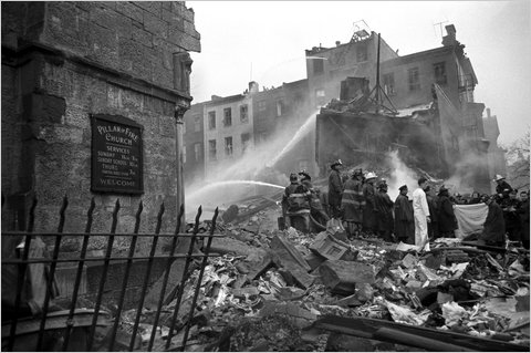
[Image: Photo by Allyn Baum for The New York Times].

In a short but otherwise quite remarkable article in today’s New York Times, we read about the barely visible traces of a plane crash that occurred 40 years ago in the skies above Park Slope, Brooklyn. As the article explains, there is “little to indicate that the corner of Seventh Avenue and Sterling Place in Park Slope, Brooklyn, bore violent witness to the worst air disaster at the time.”

“If you look closely, though, there are signs—not wounds from that harrowing day so much as faded scars.”

For the most part, these wounds from the sky take architectural form. They are urban archaeologies of airborne collision—the tragic encounter of a plane with the city—recorded in material detail:

At 126 Sterling, where a 25-foot section of the plane’s right wing knifed through a peach-brick four-story apartment complex, the building still stands, but its bunting-patterned tin cornice is gone; the two matching buildings to the right still have theirs. The first dozen courses of brick below the rebuilt roof don’t match the rest. They are shinier, lighter: newer.

Meanwhile, nearby on 7th Avenue, “at the back of the brownstone at No. 20 that caught fire, a second-floor window was never replaced and has been bricked over. Titus Montalvo, who has lived on the ground floor for nearly 40 years, said that a former landlord warned him he might find fingers while digging in the garden.”

There are even what the article refers to as “crash relics”—rusted pieces of wings—still standing in people’s back gardens like scenes from some new Catholicism of fallen machinery, as rewritten by J.G. Ballard.

But there is something almost giddy in the implication that, if only we could perform a rigorous-enough architectural forensics on the surface of the city—revealing traces of disaster hidden in ornamental cornices and bricked-up windows—then otherwise lost events could be both memorialized and reconstructed. Even the smallest mark on a building’s facade becomes a monument to forgotten histories.

Oceanic

[Image: A spectator gazes out at the wave that will destroy him; via LiveScience].

This picture has been haunting me ever since I first saw it back in June: it depicts what appears to be a man, standing on the coast of Hawaii in 1946, watching a tsunami rush to shore, bringing a wall of debris down upon him – a literal and terrifying experience of the oceanic.
Caused by a massive earthquake – or catastrophic landslide – off the coast of the Aleutian Islands, the tsunami made it all the way to Hawaii and beyond. I say earthquake or landslide because there is still some controversy over what exactly caused the wave in the first place.
The Pacific Tsunami Museum, meanwhile, with an oddly titled series called the “Tsunami Survivor Video of the Month,” has more general information about tidal waves in the Pacific.