Field Studies

[Image: Field Studies 2012 runs 10-13 September 2012 in London].

Field Studies 2012 kicks off next month in London. Previously covered on BLDGBLOG here, Field Studies—whose website unfortunately auto-plays sound—”is a four-day summer-school led by three acclaimed sound artists and composers. It explores the possibilities of engaging with places through listening, and working with recorded sound as a creative and practical tool in the context of architecture, the city and art practice.”

Placing the following questions into an architectural or urban context seems incredibly promising: “How do you notate and communicate sounds? How can listening exercises and recorded sound complement the more established creative repertory of writing, drafting and sketching, or taking photographs? How can something that is ephemeral, and ever-changing, meaningfully inform the making of things that have permanence?”

Visiting faculty and lecturers this year include Brandon LaBelle, Lee Patterson, Davide Tidoni, Helen Frosi, Joseph Kohlmaier, and Christina Kubisch.

Find out more info, including fees and eligibility, at the Field Studies website.

London Bells / Urban Instruments

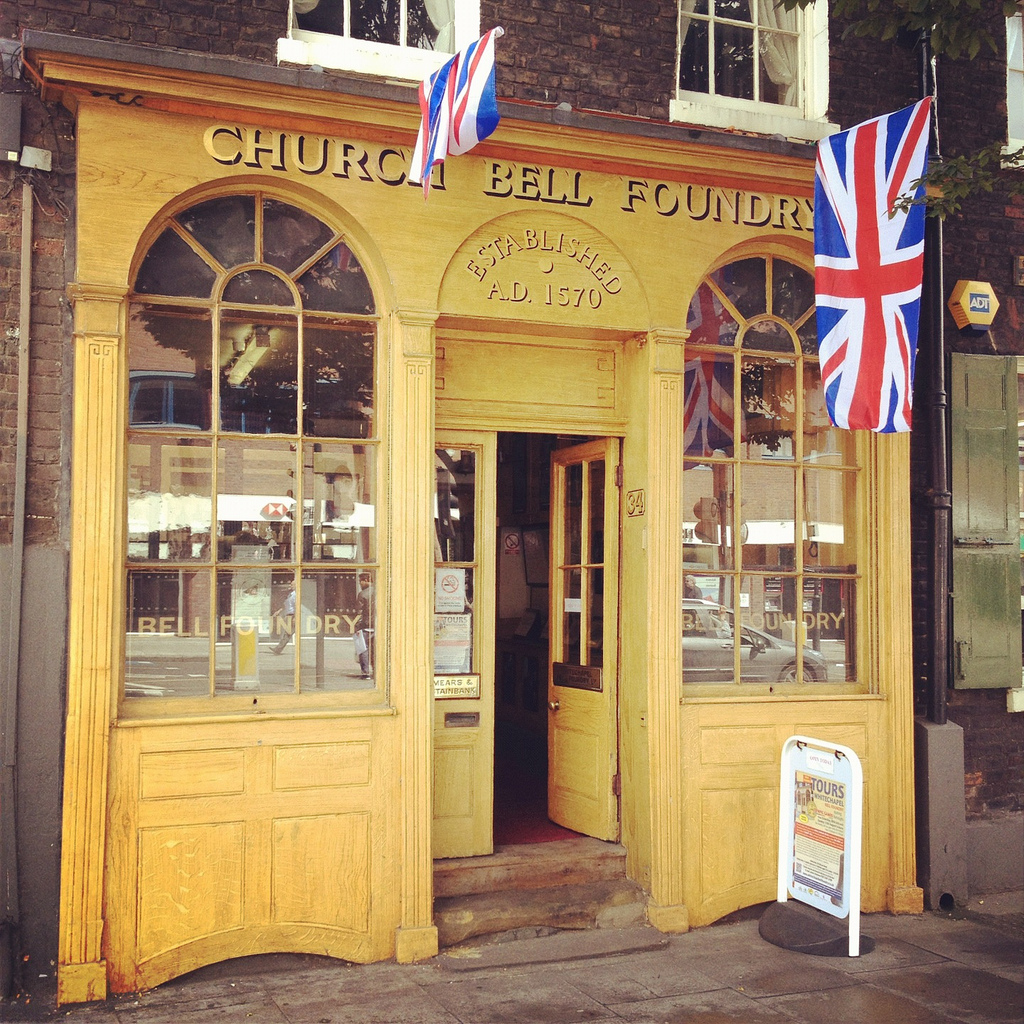
[Image: Outside the Whitechapel Bell Foundry, London; all photos by BLDGBLOG].

Before leaving London last week, I learned that the Whitechapel Bell Foundry was offering walk-in tours for the duration of the Olympics, so Nicola Twilley and I headed out to see—and hear—what was on offer.

[Image: Inside the Whitechapel Bell Foundry].

I’d say, first off, that the tour is well worth it and that everyone on hand to help us along on the self-guided tour seemed genuinely pleased to have members of the public coming through. Second of all, if you have any interest at all in the relationship between cities and acoustics—say, the influence of bells on neighborhood identity or the subtle differences in city soundscapes based on different profiles moulded into church bells—then it’s a fabulous way to spend the afternoon.

We were there for nearly two hours, but I still felt like we were rushing.

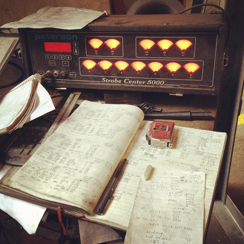
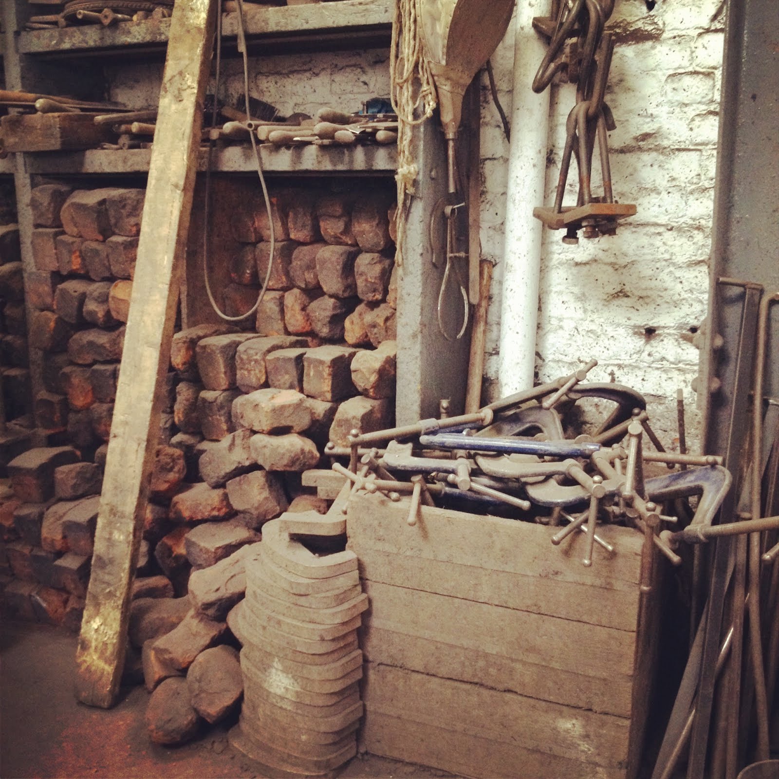
[Image: Bell-making tools at the Whitechapel Bell Foundry].

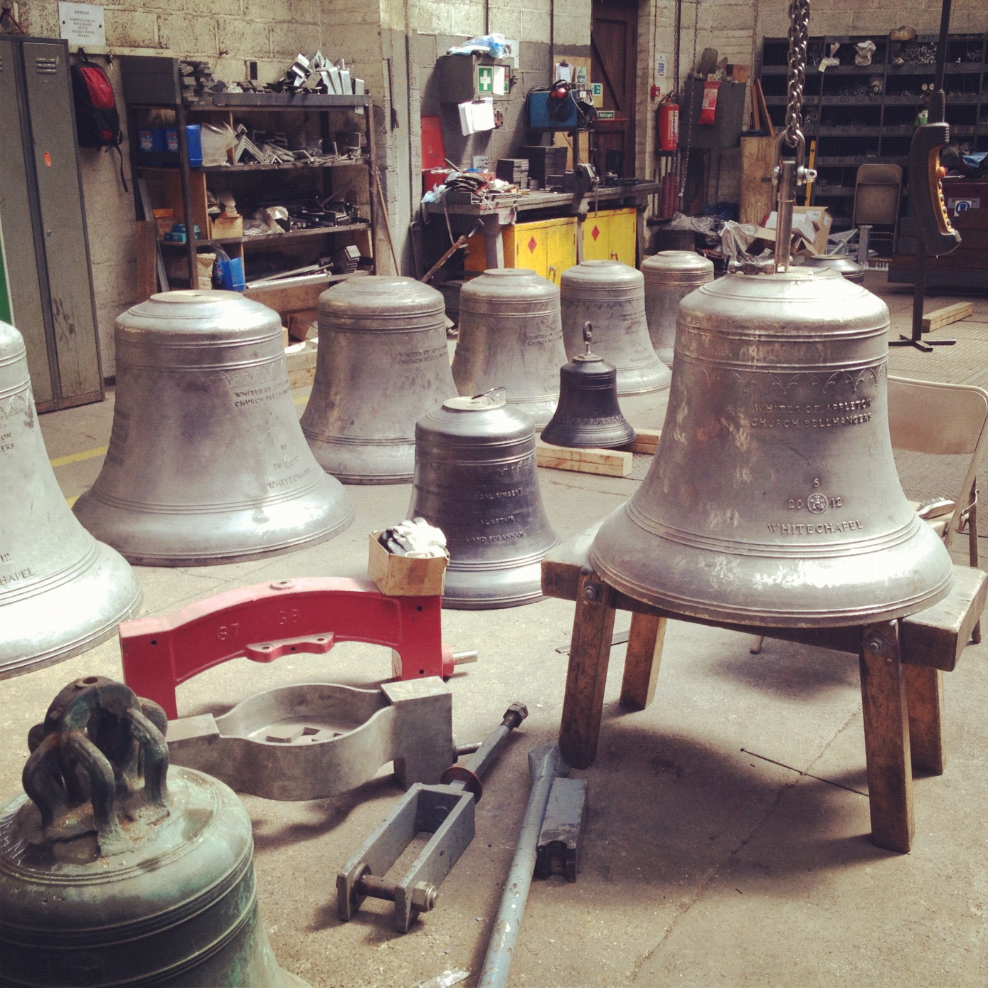
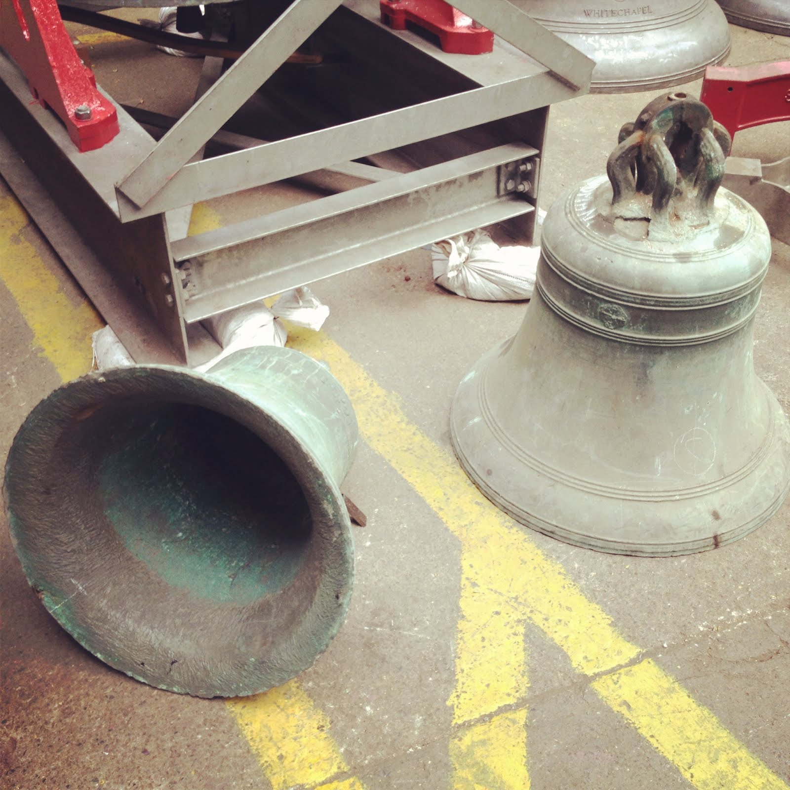
In any case, the Foundry bills itself, and is apparently recognized by the Guinness Book of World Records, as the oldest manufacturing company in Britain. They made Big Ben; they forged the first Liberty Bell; they created, albeit off-site, the absolutely massive 23-ton 2012 Olympic Bell; and, among thousands of other, less well-known projects, they even made the famed Bow bells whose ringing defines London’s Cockney stomping ground.

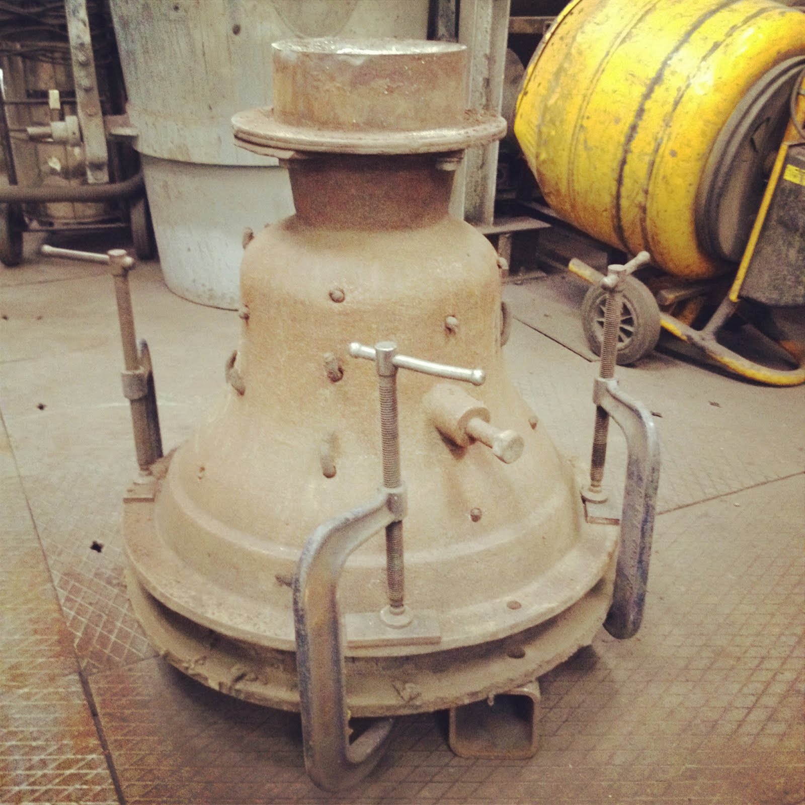
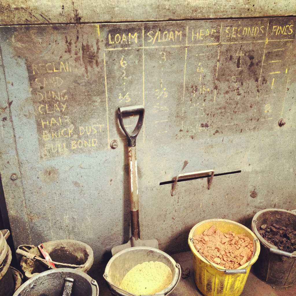
[Image: The ingredients of loam].

The self-guided tour took us from buckets of loam, used to shape the earthen moulds into which “bell metal” (an alloy of copper and tin) is later poured during casting, all the way to the mind-blowing final sight and sound of the bell-tuning station.

Here are some quick photos, then I’ll come back to the tuning process.

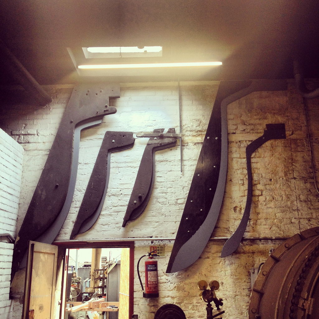
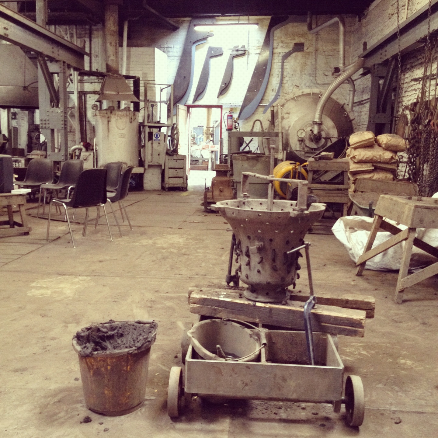
[Images: Interior of the Foundry, plus some of the casting/pouring equipment. In the bottom two images, the frames visible on the back wall were used to cast, from left to right, Big Ben; the original Liberty Bell; the Bow bells; the enormous 2012 Olympic Bell; and another bell, on the far right, that I unfortunately don’t remember].

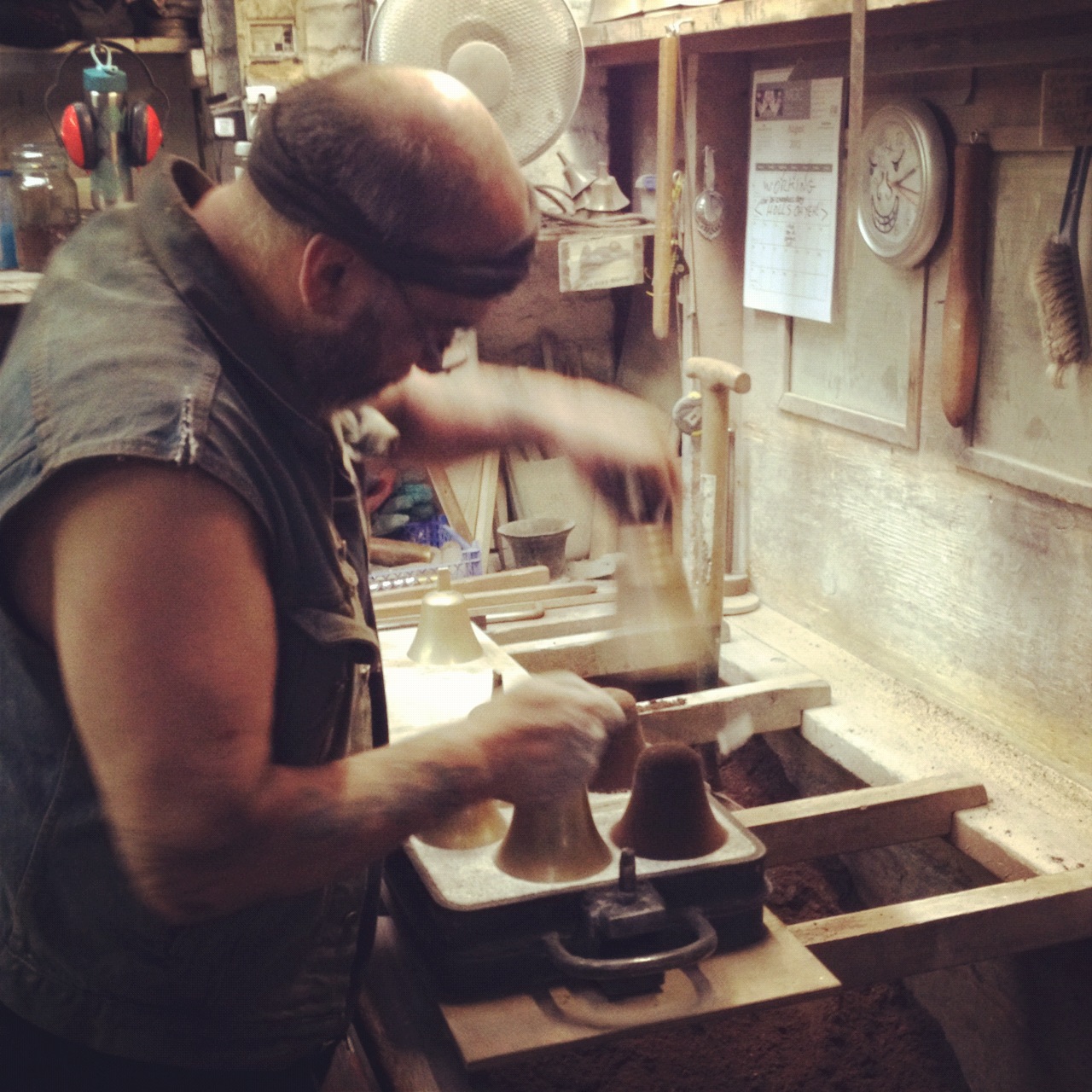
The next sequence shows the casting of hand bells. We were basically in the right place at the right time to see this process, as the gentleman pictured—whose denim vest had written on it in black marker, “I’m not mad, I’m mental, HA! HA! HA!”—pulled apart the suitcase-like casting frame seen in these photos to reveal gorgeously bright golden bells sitting silently inside.

Using powder, almost like something you’d use to sugar a cake, and an air-hose, he removed the bells from their loamy matrix and got the frame ready for another use.

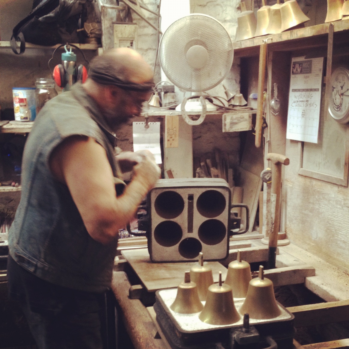
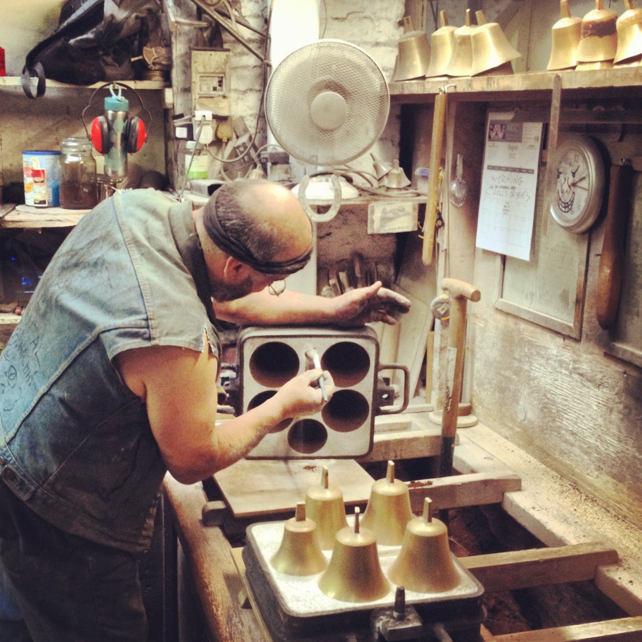
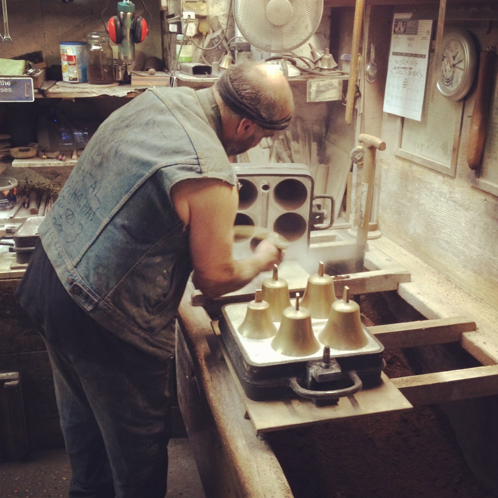
[Image: The bells are revealed and powdered].

The whole thing was a kind of infernal combination of kilns and liquid metal, soundtracked by the sharp metallic ring of bells resonating in the background.

As the origin site for urban instruments—acoustic ornaments worn by the city’s architecture to supply a clockwork soundtrack that bangs and echoes over rooftops—the Foundry had the strange feel of being both an antique crafts workshop of endangered expertise (kept afloat almost entirely by commissions from churches) and a place of stunning, almost futuristic, design foresight.

In other words, the acoustic design of the city—something that isn’t even on the agenda of architecture schools today, considered, I suppose, too hard to model with Rhino—was taking place right there, and had been for centuries, in the form of vast ovens and casting frames out of which emerge the instruments—shining bells—that so resonantly redefine the experience of the modern metropolis.

So that brings us to the final stage of the Foundry tour, which was the tuning station.

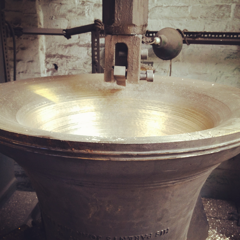
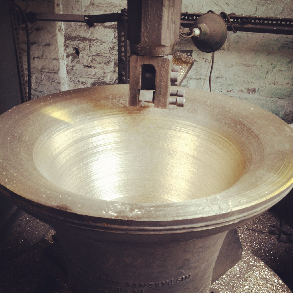
[Images: Tuning a bell; note the shining flecks of metal on the floor, which have been scraped out of the bell in order to tune it. “Tuning” is thus a kind of mass reduction, or reductive sculpting].

Assuming I remembered this correctly, modern bells are tuned by having tiny bits of metal—mere flecks at a time—scraped or cut away from the inside. This produces an incredible texture of bright, polished grooves incised directly, even violently, into the metal; the visual effect is absolutely magical.

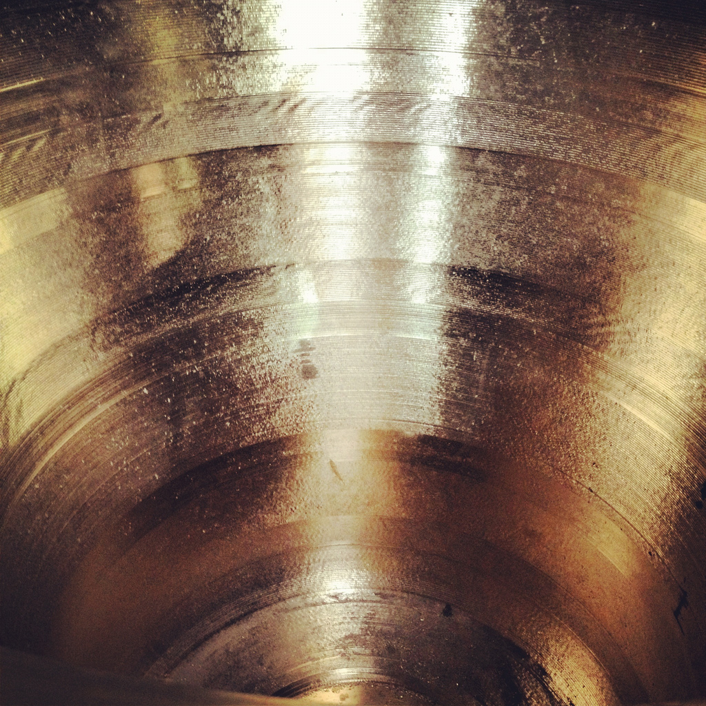
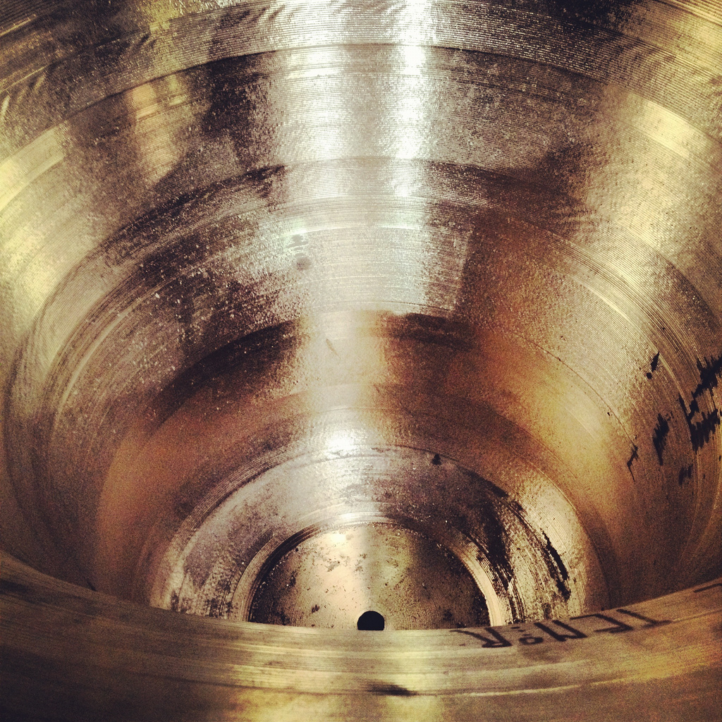
[Image: The grooved interior of a recently tuned bell; in the bottom image, note the word “tenor” written on the bell’s inner rim].

Even better, while these massive bells are rotating anti-clockwise on their turning plates, having their insides scraped away, they are actually ringing!

Deep below the abrasive droning roar of the bell turning you can make out the resonant tone of the bell itself. The effect was like listening to tuned rocks falling endlessly in a tumbler, polished into acoustically more beautiful versions of themselves. This process alone could make a new instrument: a full orchestra of bell-tuning stations, as if mining shaped metals for their sounds.

Finally, then, the tuning process is controlled by one of three ways, often used in combination. One uses software; you bang the bell with a mallet and the software tells you if it’s resonating at the right frequencies. The second method uses an oscilloscope, which looks like something straight out of a 1980s submarine-warfare movie.

[Image: As if looking for ghosts inside the bell, the oscilloscope spins and glows].

And the third is much more analogue, relying entirely on the tuner’s own sense of pitch and the use of tuning forks.

[Image: Tuning forks at the Whitechapel Bell Foundry].

At the risk of going on too long about this, there really was something almost indescribably beautiful about the tuning process: watching, and listening to, otherwise featureless metal surfaces be sculpted and inscribed from inside by an anti-clockwise machine as the weird circular howl of the bell grew gradually more distinct, more precisely pitched with every scraping away of unpolished metal.

Being, as you’ll know by now, prone to clichés, I can’t help but think of William Blake’s “Satanic Mills” of the Industrial Revolution every time I enter an industrial facility these days, and a vision of some titanic factory somewhere in the pollution of a future era, spinning raw metal into bells, golden and shrieking things droning as if enspirited or possessed, is almost too fantastical to contemplate.

Anyway, the Whitechapel Bell Foundry is open for walk-in tours, for £10 per adult, until the end of the 2012 Olympics, after which the tours go back to advance reservations only (and the ticket price goes up to £12). Enjoy!

The Moon and the Meadowlands

Two Studio-X network events that might be of interest this week:

For those of you in or near Mumbai, India, on Friday, August 10th, architect and “aerospace entrepreneur” Susmita Mohanty—previously seen on BLDGBLOG here—will be discussing the design possibilities for architecture in lunar environments. The talk takes place at Studio-X Mumbai, it starts at 6:30pm, and it can be found at Kitab Mahal, 192 D.N. Road, Fort, Mumbai 400001.

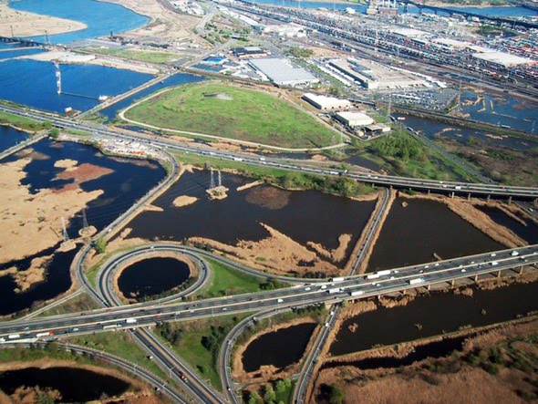
Back here in New York, meanwhile, on Saturday, August 11th, Matthew Coolidge, director of the Center for Land Use Interpretation, will present his recent (and ongoing) research into the landscape infrastructures of the Meadowlands. Some of you might remember this post on the Meadowlands from two summers ago; if not, it’s a good starting point to pique your curiosity before Coolidge’s talk.

Coolidge will show a “slideshow safari into the industrial swamps of the Meadowlands… a superlative antipode to the great urban spaces that surround it,” at Studio-X NYC, 180 Varick Street, Suite 1610, 16th floor, kicking off at 7:30pm. Free and open to the public; no RSVP required.

Highways and Rivers Bureau

In the Gilbert Highet book mentioned previously, Highet dedicates a chapter to the poetry of Catullus, including a brief biographical aside on Catullus’s time spent, somewhat surreally, as an imperial administrator in Bithynia, or northwest Turkey. Here, Highet inserts a paranthetical aside, hoping to draw a comparison that would suggest an entire and, as it happens, incredibly interesting parallel history for European literature: “(Imagine Lord Byron as assistant principal of the Highways and Rivers Bureau of a small province in India.)” Imagine, indeed, Byron in the Himalayas, writing of river meanders and mountain forts, deltas the size of whole English counties and flooded step wells, and the poetry that might result.

Below, buried beneath the very roots of the trees

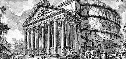
[Image: Piranesi’s Rome].

Peter Ackroyd’s allusion to a landscape comparable to the tropical swamps of Borneo found in the sewers of London reminded me of a brief line in Gilbert Highet’s book Poets in a Landscape.

Describing the origins of Rome, a city built on the Tiber River, Highet writes that the landscape there was once as wild as any to be found on earth—indeed, offering evidence that writers seem consistently to fantasize of finding a new tropics in the very ground of Europe, Rome was founded in “those early idyllic days, when the Tiber was as primitive as the Upper Amazon today.”

Highet goes on to describe the city’s long-term devolution into the “heap of ruins” it became in the Middle Ages, a city “earth-choked, mutilated, silent,” one where weeded streets were lined with “the titanic palaces of later monarchs—arches which now look not so much like relics of human architecture as fragments of mountain-ranges into which dwellings have been built.”

“In those days,” Highet writes, a variant form of “primitive” landscape emerged, one in which forests returned and plants ran riot, when “Rome was a place of grassy ruins and elegant palaces and whispering melancholy churches, little changed from the strange half-visionary city immortalized in the engravings of Piranesi: tall pillars standing among rocks and mounds which prove to be the fallen walls and earthquake-shattered arches of some vast mansion; huge fields in which a few peasants stand gossiping while their goats scramble among carved pilasters, and which are at a great distance revealed as being, not fields, but the overgrown floors of temples and baths; lonely obelisks once designed to perpetuate some Roman glory, and now purposeless, mighty circular tombs converted during the Middle Ages into fortresses; hills which covered buried palaces.” The ruin, here, “earth-choked, mutilated, silent,” could thus be seen as a vertiginous act of misrecognition: architecture mistaken for the surface of the earth.

Even the supersized spatial affectations of someone like Emperor Nero, Highet continues, could not ultimately resist the inhuman pull of insects and vegetation that settled onto Rome: “so many centuries after Nero shocked his contemporaries by insisting on making a private landscape in the midst of a crowded metropolis, the ruins of his palace have gone back to nature. Bees hum through the roofless corridors; flowering weeds flourish among the imperial brickwork; from the sunlight above we hear the voices of children running and laughing on the grassy slopes.”

Highet was writing nearly half a century ago, but it’s still accurate that, as he writes, visitors to the city are able to “feel the ephemeral happiness of summer flowers and summer birds all around, to enjoy the fresh warm air and the genial quietness, and to reflect that below, buried beneath the very roots of the trees, clogged with hundreds of tons of earth and fallen masonry, shrouded in the darkness of many disastrous centuries, there lie some of the foundations of our world”—foundations built and implanted when the region was “Amazonian” in its humid and unsettled wildness.

A narrative from the swamps of Borneo

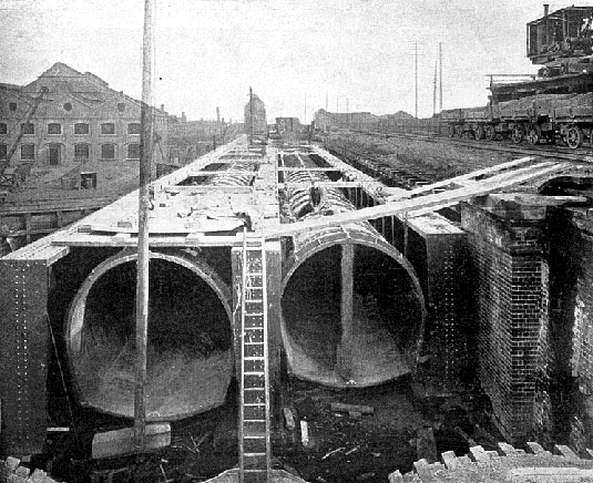
[Image: London’s sewers under construction; via the fascinating
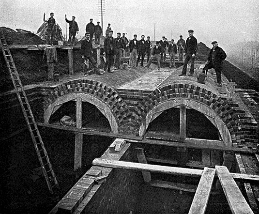
 Sewer History site].

At one point in his recent overview of all things under London, from plague pits to bank vaults and buried rivers to Cold War government bunkers, author Peter Ackroyd quips that descriptions of the humid and microbiologically overgrown tunnels of the city’s sewers “might be a narrative from the swamps of Borneo rather than the City of London.”

[Image: Courtesy of Sewer History].

In a chapter appropriately called “Heart of Darkness”—”this was the heart of darkness,” Ackroyd writes, “the lowest depth of a city that was already being described as a wilderness”—Ackroyd introduces us to several centuries’ worth of sewer work, including the “flushers” or hardy laborers hired to enter the tunnels physically and help push—or “flush”—the waste out from sites of stagnation.

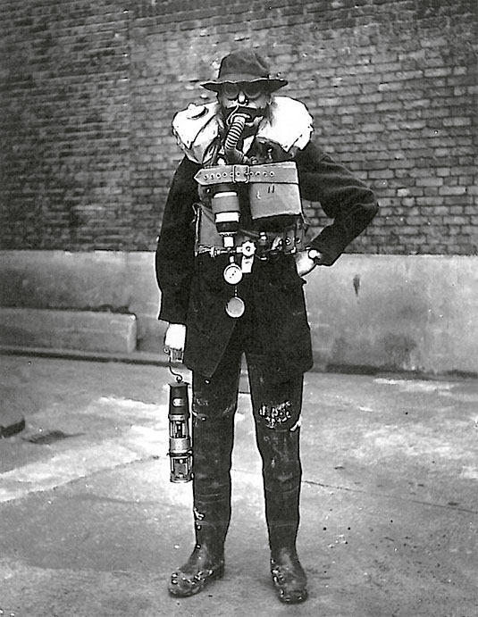
[Image: A “flusher,” courtesy of
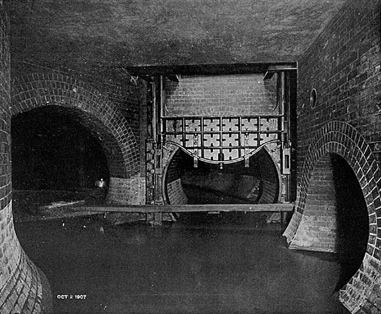
 Sewer History; for those of you interested in the state of “flushing” today, don’t miss Edible Geography‘s interview with Julio the sewer diver, or this look at “fatbergs” in London].

Bizarrely, but somehow fittingly, these sewers always seem to remain imperfectly mapped, with no one person or government office in particular possessing a full chart or atlas of all the twisty passages.

This unmapped condition has, of course, at various times in history, necessitated a survey.

[Image: Courtesy of Sewer History].

“A survey of the sewers of London was undertaken in the summer and autumn of 1848,” Ackroyd writes, “when their condition was described as ‘frightful’; the system was dilapidated and decayed, even dangerous.”

Workers sent below encountered titanic rooms dripping with grotesque stalactites made from human waste, mushrooms nearly “as large as ordinary soup-tureens” growing on the brickwork, and such poor and unventilated air that some surveyors had to be “dragged out… in a state of insensibility.”

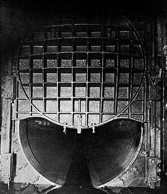
[Image: Great iron doors beneath the city; courtesy of Sewer History].

This only increased the sense of near-unearthly wonder that colored popular descriptions of the city’s artificial underworld: “The reports of the world beneath are written in a generally breathless tone, compounded of fear and awe.”

The underground chambers are compared to cathedrals, complete with pillars and buttresses, arches and crypts. One visitor, discovering an archway through which a cataract tumbled, remarked that it was as fantastic a scene as ‘a dream of a subterranean monastery.’ The travelers walk along tunnels that may reach a height of 17 feet, the cool tainted water lapping at about knee-height around their waders. Many are disconcerted by the pull of the water, and feel disoriented; they lose their equilibrium. They feel the sediment beneath their feet, as if they were walking on a beach at low tide. Great iron doors loom up at intervals, actings as valves. The noise of roaring water, somewhere in the distance, can generally be heard. It is the sound of cataracts and waterfalls.

It is here, on this literal beach beneath the streets, that Ackroyd makes the tropical implications most explicit, where a landscape more like “the swamps of Borneo” is discovered, an urban tropics, steaming and wild under London.

Fire-Walking New York City

[Image: Combustible City by Common Room].

The New York-based group Common Room will soon be publishing and displaying in their space a series of walks around the city, walks that, in their words, “demonstrate, at four different spatial scales, the agency of combustion in shaping the city’s architecture, infrastructure and imaginary [sic].”

Devised and authored by Adam Bobbette, the tours will include sites and experiences such as walking “the perimeter of the great fire of 1835,” exploring the “former sites of fire towers in Manhattan,” and more:

Additionally, the tours recount the history of the fireproof building, the epistemological relationships between panoramas, hot air balloons and fire towers, the changing shape of water in the city, and the hyperreality of prevention. Together, these tours reveal another city nested within New York City, a city in plain view but rarely considered; this city is constituted by and through the management and care for its own inherent fragility, this city is named Combustible City.

I’m reminded of a recent book on my wishlist for the summer: Flammable Cities: Urban Conflagration and the Making of the Modern World by Greg Bankoff, which describes itself as “the first truly global study of urban conflagration.” Bankoff “shows how fire has shaped cities throughout the modern world, from Europe to the imperial colonies, major trade entrepôts, and non-European capitals, right up to such present-day megacities as Lagos and Jakarta. Urban fire may hinder commerce or even spur it; it may break down or reinforce barriers of race, class, and ethnicity; it may serve as a pretext for state violence or provide an opportunity for displays of state benevolence. As this volume demonstrates, the many and varied attempts to master, marginalize, or manipulate fire can turn a natural and human hazard into a highly useful social and political tool.”

Bobbette’s fire walks of New York City will be on display at Common Room from July 16-August 16, and I believe more information will be available soon on their website.

(Previously on BLDGBLOG: The Fires. Thanks to Carlos Solis for the tip!)

Fields of the Future

Peter Brewer, an ocean chemist at Monterey, is working on what Nature Climate Change calls an “underwater aquarium.”

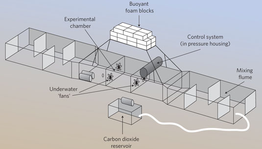
[Image: A diagram of Peter Brewer’s “underwater aquarium,” via Nature Climate Change].

It is, Brewer explains, “a 10m-long flume with an experimental chamber that sits on a patch of sea floor containing animals whose response to ocean acidification is to be tested.”

Brewer’s artificial chemical microclimate—a partially enclosed carbon dioxide bloom—is framed by an architecture of buoyant bricks and mixing fans. “At present, it is on the sea floor about 850m below the ocean surface and 25km offshore,” he adds.

The use of this technically enhanced architectural device to test undersea creatures—with its M.C. Escher-like logic of an aquarium surrounded by water—brings to mind other experiments for spatially probing the limits of life, including modified-atmosphere aviaries or even the Duke Forest, a forest-within-the-forest dotted with carbon dioxide-emitting masts.

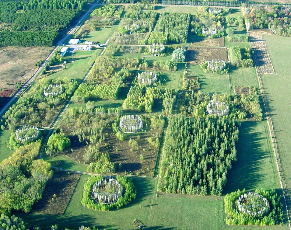
[The “Aspen FACE,” or Northern Forest Ecosystem Experiment].

The Northern Forest Ecosystem Experiment in Wisconsin, pictured above, is another example of using spatial tools to frame and demarcate an augmented ecosystem.

Further, there is an interestingly asynchronous quality to these experimental terrains: in each case, they are technically enhanced landscapes for the production of a speculative future biome, these and other “fields of the future” simulating what regions of the earth might be like in 50-100 years’ time.

Urban Target Complex National Monument

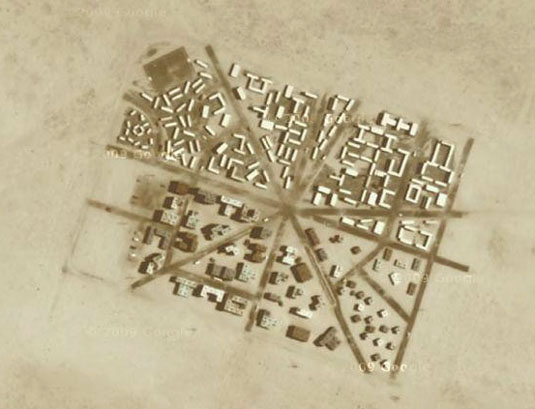
[Image: Yodaville, via Google Maps].

Yodaville is a fake city in the Arizona desert used for bombing runs by the U.S. Air Force. Writing for Air & Space Magazine back in 2009, Ed Darack wrote that, while tagging along on a training mission, he noticed “a small town in the distance—which, as we got closer, proved to have some pretty big buildings, some of them four stories high.”

As towns go, this one is relatively new, having sprung up in 1999. But nobody lives there. And the buildings are all made of stacked shipping containers. Formally known as Urban Target Complex (R-2301-West), the Marines know it as “Yodaville” (named after the call sign of Major Floyd Usry, who first envisioned the complex).

As one instructor tells Darack, “The urban layout is actually very similar to the terrain in many villages in Iraq and Afghanistan.”

The Urban Target Complex, or UTC, was soon “lit up with red tracer rounds and bright yellow and white rocket streaks,” till it “looked like it was barely able to keep standing”:

The artillery and mortars started firing, troops advanced toward the target complex, and aircraft of all types—carefully controlled by students on the mountain top—mounted one attack run after another. At one point so much smoke and dust filled the air above the “enemy” that nothing could be seen of the target—just one of the real-world problems the students had to learn to cope with that day.

In a recent article for the Tate, writer Matthew Flintham explores “the idea of landscape as an extension of the military imagination.” Referring specifically to the UK, he adds that what he perceives as a contemporary “lack of artistic engagement with the activities of the Ministry of Defence (MoD) is perhaps principally due to the relative segregation of defence personnel, land and airspace from the civil domain.”

Flintham points out—again, referring to the UK—that “today’s MoD has its own vast training estate with numerous barracks and an enormous stock of housing, all of which are detached from public scrutiny. The public are prevented from accessing many areas of the defence estate for two reasons: the extreme danger of live weapons and hazardous activities (and related issues of potential litigation), and the restrictions on privileged, strategic or commercial information in the interests of national security.” This has the effect that these sorts of military landscapes not only fall outside critical scrutiny—and also remain, with very few exceptions, all but invisible to architectural critique—but that their only real role in the public imagination is entirely speculative, often based solely on rumor and verging on conspiracy.

While Flintham thus calls for a more active artistic engagement with military landscapes, exploring what he calls the “military-pastoral complex,” I would echo that with a related suggestion that spaces such as Yodaville belong on the architectural itinerary of today’s design writers, critics, and students.

Given the mitigation of the very obvious problems Flintham himself points out—such as site contamination, unexploded ordnance, and national security leaks—it would be thrilling to see a new kind of “fortifications tour,” one that might bring these sorts of facilities into the public experience.

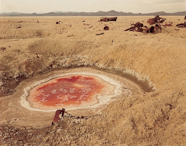
[Image: Photo by Richard Misrach, courtesy of the Whitney Museum of American Art, from Bravo 20].

An interesting possibility for this sort of national refocusing on military landscapes comes from artists Richard and Myriam Misrach. The Misrachs have proposed a “Bravo 20 National Park“—that is, “turning the blasted range into a National Park of bombing,” as the Center for Land Use Interpretation phrases it. “When the Navy’s use of Bravo 20 was up for Congressional review in 1999,” CLUI continues, “Misrach made one more heroic, quixotic, and failed attempt to get his proposal seriously considered. Instead, the Navy has increased its use of Bravo 20, and the four other ranges around Fallon, and has been authorized to expand their terrestrial holdings in the area by over 100,000 acres.”

So what, for instance, might something like a Yodaville National Park, or Urban Target Complex National Monument, look like? How would it be managed, touristed, explored, mapped, and understood? What sorts of trails and interpretive centers might it host? Alternatively, in much the same way that the Unabomber’s cabin is currently on display at the Newseum in Washington D.C., could Yodaville somehow, someday, become part of a distributed collection of sites owned and operated by the Smithsonian, the National Building Museum, or, for that matter, UNESCO, in the latter case with Arizona’s simulated battlegrounds joining Greek temples as world heritage sites?

In any case, bringing spaces of military simulation into the architectural discussion, and reading about Yodaville in, say, Architectural Record instead of—or in addition to—Air & Space Magazine, would help to demystify the many, otherwise off-limits, landscapes produced (and, of course, destroyed) by military activity. Better, this would reveal even the cloudiest of federal lands as spatial projects, nationally important places that—again, given declassification and appropriate environmental remediation—might hold unexpected insights for design practitioners, let alone for critics, the public, and national historians.

(Thanks to Mark Simpkins for the Tate link).

Various forms of lithic disguise

I finally had a chance to read John McPhee’s book La Place de la Concorde Suisse, his somewhat off-puttingly titled 1984 look at the Swiss military and its elaborately engineered landscape defenses.

[Image: Swiss mountain pass, via Google Image Search].

To make a long story short, McPhee describes two things: how Switzerland requires military service from every able-bodied male Swiss citizen—a model later emulated and expanded by Israel—and how the Swiss military has, in effect, wired the entire country to blow in the event of foreign invasion. To keep enemy armies out, bridges will be dynamited and, whenever possible, deliberately collapsed onto other roads and bridges below; hills have been weaponized to be activated as valley-sweeping artificial landslides; mountain tunnels will be sealed from within to act as nuclear-proof air raid shelters; and much more.

First, a quick look at the system of self-demolition that is literally built into the Swiss national infrastructure:

To interrupt the utility of bridges, tunnels, highways, railroads, Switzerland has established three thousand points of demolition. That is the number officially printed. It has been suggested to me that to approximate a true figure a reader ought to multiply by two. Where a highway bridge crosses a railroad, a segment of the bridge is programmed to drop on the railroad. Primacord fuses are built into the bridge. Hidden artillery is in place on either side, set to prevent the enemy from clearing or repairing the damage.

Further:

Near the German border of Switzerland, every railroad and highway tunnel has been prepared to pinch shut explosively. Nearby mountains have been made so porous that whole divisions can fit inside them. There are weapons and soldiers under barns. There are cannons inside pretty houses. Where Swiss highways happen to run on narrow ground between the edges of lakes and to the bottoms of cliffs, man-made rockslides are ready to slide.

The impending self-demolition of the country is “routinely practiced,” McPhee writes. “Often, in such assignments, the civilian engineer who created the bridge will, in his capacity as a military officer, be given the task of planning its destruction.”

But this is where a world of weirdly fascinating artifice begins. After all, McPhee writes, why would Switzerland want anyone to know where the dynamite is wired, where the cannons are hidden, which bridges will blow, or where to find the Army’s top secret mountain hideaways and resupply shelters? But if you look closely, you start to see things.

Through locked gates you see corridors in the sides of mountains—going on and on into the rock, with a light in the ceiling every five meters and far too many to count… Riding around Switzerland with these matters in mind—seeing little driveways that blank out in mountain walls, cavern entrances like dark spots under mountainside railroads and winding corniches, portals in various forms of lithic disguise—you can find it difficult not to imagine that almost anything is a military deception, masking a hidden installation.

Indeed, at one point McPhee jokes that his local guide in Switzerland “tends to treat the army itself as if it were a military secret.”

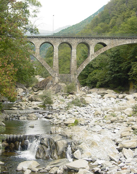
[Image: Swiss bridge, photographed by Aaron Plewke].

McPhee points to small moments of “fake stonework, concealing the artillery behind [them],” that dot Switzerland’s Alpine geology, little doors that will pop open to reveal internal cannons that will then blast the country’s roads to smithereens. Later, passing under a mountain bridge, McPhee notices “small steel doors in one pier” hinting that the bridge “was ready to blow. It had been superceded, however, by an even higher bridge, which leaped through the sky above—a part of the new road to Simplon. In an extreme emergency, the midspan of the new bridge would no doubt drop on the old one.”

It’s a strange kind of national infrastructure, one that is at its most rigorously functional—one that truly fulfills its promises—when in a state of cascading self-imposed collapse.

I could easily over-quote my way to the end of my internet service here, but it’s a story worth reading. There are, for instance, hidden bomb shelters everywhere in an extraordinary application of dual-use construction. “All over Switzerland,” according to McPhee, “in relatively spacious and quiet towns, are sophisticated underground parking garages with automatic machines that offer tickets like tongues and imply a level of commerce that is somewhere else. In a nuclear emergency, huge doors would slide closed with the town’s population inside.”

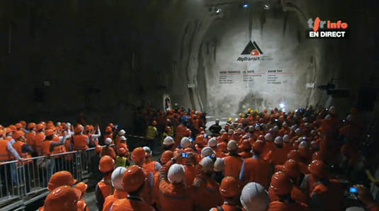
[Image: Switzerland’s Gotthard Tunnel, via genevalunch.com].

Describing titanic underground fortresses—”networks of tunnels, caverns, bunkers, and surface installations, each spread through many tens of square miles”—McPhee briefly relates the story of a military reconnaissance mission on which he was able to tag along, involving a hydroelectric power station built inside a mountain, accessible by ladders and stairs; the battalion tasked with climbing down into it thus learns “that if a company of soldiers had to do it they could climb the mountain on the inside.”

In any case, the book‘s vision of the Alps as a massively constructed—or, at least, geotechnically augmented and militarily amplified—terrain is quite heady, including the very idea that, in seeking to protect itself from outside invaders, Switzerland is prepared to dynamite, shell, bulldoze, and seal itself into a kind of self-protective oblivion, hiding out in artificially expanded rocky passes and concrete super-basements as all roads and bridges into and out of the country are instantly transformed into landslides and dust.

Primary Landscapes

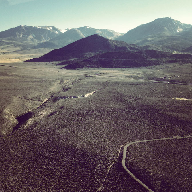
[Image: Around Mono Lake, photo by BLDGBLOG].

The last week has been pretty slow here as we get Venue up and running; but there are some new posts over at the Venue website that I think are worth checking out.

One is a brief, image-heavy round-up from an amazing flight I took last week with photographer Michael Light in his two-seater, fiber-glass aircraft around the shore of Mono Lake, California. A full-length interview with Light is forthcoming, as well.

The other is an interview with photographer Edward Burtynksy, who we had the pleasure of meeting last week at the Nevada Museum of Art for Venue’s inaugural interview. Among discussions of Burtynsky’s most recent series, Oil—which just opened at the Nevada Museum of Art—and the ongoing Water project, we asked Burtynsky about the more technical side of his work, including the deployment of drones in photographing otherwise inaccessible sites, and the somewhat puzzled reactions his work has received from people working in the industries he photographs.

Check those out if you get a chance, and new posts will also appear here on BLDGBLOG soon.