Infrastructural Voodoo Doll

For the past few months, on various trips out west to Los Angeles, I’ve been working on an exclusive story about a new intelligence-gathering unit at LAX, the Los Angeles International Airport.

To make a long story short, in the summer of 2014 Los Angeles World Airports—the parent organization in control of LAX—hired two intelligence analysts, both with top secret clearance, in order to analyze global threats targeting the airport.

There were many things that brought me to this story, but what particularly stood out was the very idea that a piece of transportation infrastructure could now punch above its weight, taking on the intelligence-gathering and analytical capabilities not just of a city, but of a small nation-state.

It implied a kind of parallel intelligence organization created to protect not a democratic polity but an airfield. This suggested to me that perhaps our models of where power actually lies in the contemporary city are misguided—that, instead of looking to City Hall, for example, we should be focusing on economic structures, ports, sites of logistics, places that wield a different sort of influence and require a new kind of protection and security.

From the article, which is now online at The Atlantic:

Under the moniker of “critical infrastructure protection,” energy-production, transportation-logistics, waste-disposal, and other sites have been transformed from often-overlooked megaprojects on the edge of the metropolis into the heavily fortified, tactical crown jewels of the modern state. Bridges, tunnels, ports, dams, pipelines, and airfields have an emergent geopolitical clout that now rivals democratically elected civic institutions.

For me, this has incredible implications:

It might sound like science fiction, but, in 20 years’ time, it could very well be that LAX has a stronger international-intelligence game than many U.S. allies. LAX field agents could be embedded overseas, cultivating informants, sussing out impending threats. It will be an era of infrastructural intelligence, when airfields, bridges, ports, and tunnels have, in effect, their own internal versions of the CIA—and LAX will be there first.

There are obvious shades here of Keller Easterling’s notion of “extrastatecraft,” where infrastructure has come to assume a peculiar form of political authority.

As such, it also resembles an initiative undertaken by the NYPD in the years immediately following 9/11—a story well told by at least three books, Peter Bergen’s excellent United States of Jihad, Christopher Dickey’s Securing the City, and, more critically, Enemies Within by Matt Apuzzo and Adam Goldman.

However, there is at least one key difference here: the NYPD unit was operating as an urban-scale intelligence apparatus, whereas the L.A. initiative exists at the level of a piece of transportation infrastructure. Imagine the Holland Tunnel, I-90, or the M25 hiring its own in-house intel team, and you can begin to imagine the strange new powers and influence this implies.

In any case, the bulk of the piece is focused on introducing readers to the core group of people behind the program.

There is Anthony McGinty, a former D.C. homicide detective and Marine Reserve veteran, kickstarting a second career on the west coast; there is Michelle Sosa, a trilingual Boston University grad with a background in intelligence analysis; and there is Ethel McGuire, one of the first black female agents in FBI history, who undertook their hiring.

There are, of course, literally thousands of others of people involved, from baggage handlers and the LAX Fire Department to everyday travelers. LAX, after all, is a city in miniature:

At more than five square miles, it is only slightly smaller than Beverly Hills. More than 50,000 badged employees report to work there each day, many with direct access to the airfield—and thus to the vulnerable aircraft waiting upon it. More than 100,000 passenger vehicles use the airport’s roads and parking lots every day, and, in 2015 alone, LAX hosted 75 million passengers in combined departures and arrivals.

LAX is also policed like a city. The airport has its own SWAT team—known as the Emergency Services Unit—and employs roughly 500 sworn police officers, double the number of cops in the well-off city of Pasadena and more than the total number of state police in all of Rhode Island.

However, the actual space of the airport—the built landscape of logistics—is probably the main potential source of interest for BLDGBLOG readers.

For example, at the western edge of the airfield, there is an abandoned suburb called Surfridge, its empty streets and sand dunes now used as a butterfly sanctuary and as a place for police-training simulations. The runways themselves are vast symbolic landscapes painted with geometric signs that have to be read to be navigated. And then there are the terminals, currently undergoing a massive, multibillion dollar renovation campaign.

At one point, I found myself sitting inside the office complex of Gavin de Becker, an anti-assassination security expert who has worked for celebrities, foreign dignitaries, and even U.S. presidents. Protected behind false-front signage, de Becker’s hidden complex houses a full-scale airplane fuselage for emergency training, as well as ballistic dummies and a soundproofed shooting range.

I had a blast working on this piece, and am thrilled that it’s finally online. Check it out, if you get a chance, and don’t miss the speculative “case files” at the end, brief examples of what might be called infrastructural security fiction.

(Thanks to Ross Andersen and Sacha Zimmerman at The Atlantic for the edits. All images in this post from Google Maps, filtered through Instagram).

Covert Cartographics

[Image: Map Measuring Tool, CIA].

The U.S. Central Intelligence Agency has uploaded a massive set of images from their historic mapping unit to Flickr.

[Image: Triangular 24-Inch Engineering Scale, CIA].

The collections include state-of-the-art graphic tools for producing maps and other measured cartographic products, as well as the maps themselves. Organized by the decade of its production—including batches from the 1940s, 1950s, and 1960s—“each map is a time capsule of that era’s international issues,” as Allison Meier points out.

[Image: Terrain map of the Sinai Peninsula (1950s), CIA, CIA].

“The 1940s include a 1942 map of German dialects,” Meier writes, “and a 1944 map of concentration camps in the country. The 1950s, with innovative photomechanical reproduction and precast lead letters, saw maps on the Korean War and railroad construction in Communist China. The 1960s are punctuated by the Cuban Missile Crisis and Vietnam War, while the 1970s, with increasing map automation, contain charts of the Soviet invasion of Afghanistan, and the Arab oil embargo.”

[Images: The Austin Photo Interpretometer, CIA].

But it’s the mapping tools themselves that really interest me here.

On one level, these graphic devices are utterly mundane—triangular rulers, ten-point dividers, and interchangeable pen nibs, for example, any of which, on its own, would convey about as much magic as a ballpoint pen.

[Image: 10-Point Divider, CIA].

Nonetheless, there is something hugely compelling for me in glimpsing the actual devices through which a country’s global geopolitical influence was simultaneously mapped and strategized.

[Images: Rolling Disc Planimeter, CIA].

As the CIA points out, their earliest mapping division “produced some 8,000 hand-drawn maps and 64 plaster topographic 3-D models in support of the war effort. Many of their products played crucial roles in the planning and execution of major military operations in the European, North African, and Asian Theaters. On display here are just some of the many tools that OSS cartographers employed in their production process.”

[Image: Dietzgen Champion Drawing Instruments, CIA].

In a sense, it’s not unlike seeing the actual typewriter with which a particular author wrote her novels, or the battered, handheld sketchbooks a painter once carried with him to a distant mountaintop—only here, in art historical terms, we are looking at the graphic tools and visual documents through which a country’s overseas influence was realized and maintained.

It is a narrative of covert state power as relayed through cartographic objects, the outlines of an imperial nation-state arising from them like a ghost.

[Image: Stanley Improved Pantograph, CIA].

I’m reminded of one of my favorite books on the subject of geopolitics, literally understood: Rachel Hewitt’s Map of a Nation: A Biography of the Ordnance Survey.

Among other things, Hewitt’s book reveals the often deeply strange tools—including surreal glass rods—through which British mapmakers and other agents of terrestrial exploration measured their nascent empire, helping to transform landscape into a mathematized system of coordinates and, in the process, conveying to British authorities the exact volumetric extent of their political domain.

There was the empire, in other words—but there were also these exotic objects of measurement through which that same empire was conjured, as if through cartographic magic.

[Image: Keufel & Esser 20.5-inch Slide Rule, CIA].

In any case, check out more at the CIA’s “Cartography Tools” Flickr set.

(Originally spotted via Alessandro Musetta).

The Great Man-Made River

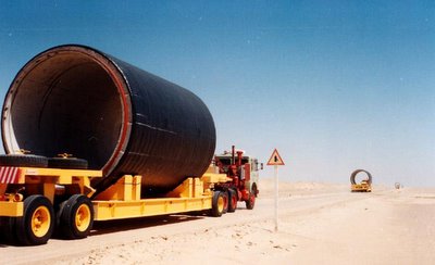
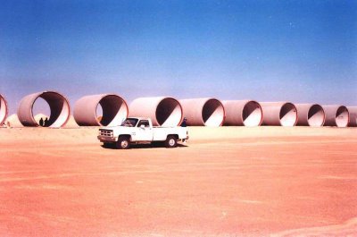
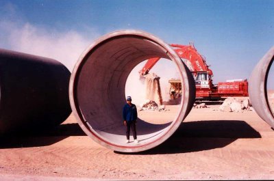
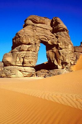
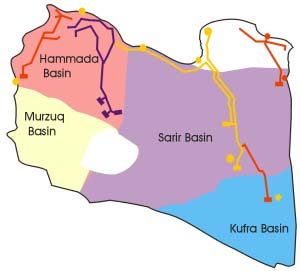
Libya’s Great Man-Made River is “an enormous, long-term undertaking to supply the country’s needs by drawing water from aquifers beneath the Sahara and conveying it along a network of huge underground pipes.”

[Images: The concrete skeleton of Libya’s future river, the “8th wonder of the world,” being trucked into place; photographed by Jaap Berk].

Not only does Libya bear the distinction of holding the world record for hottest recorded temperature (136º F), but most of the country’s terrain is “agriculturally useless desert” that receives little or no rainfall. The Great Man-Made River may not even successfully irrigate Libya’s governmentally-specified agricultural zones, but due to the region’s complete “absence of permanent rivers or streams” – and because the country’s “approximately twenty perennial lakes are brackish or salty” – the River’s expected 50-100 year lifespan is at least a start.

Indeed, Libya’s “limited water is considered of sufficient importance to warrant the existence of the Secretariat of Dams and Water Resources, and damaging a source of water can be penalized by a heavy fine or imprisonment.” George Orwell would perhaps call this watercrime.

However, I have to say that the prospect of spelunking through the Great Man-Made River’s subterranean galleries in 125 years, once those tunnels have dried-up, makes the brain reel. Imagine Shelleys of the 22nd century wandering through those ruins, notebooks in hand, taking photographs, footsteps echoing rhythmically beneath the dunes as they walk for a thousand kilometers toward the sea…

Yet some are skeptical of the project’s real purpose. Precisely because the Great Man-Made River consists of “a stupendous network of underground tunnels and caverns built with the help of Western firms to run the length and width of the country,” some consultants and engineers “have revealed their suspicion that such facilities were not meant to move water, but rather to conceal the movement and location of military-related activities.” The fact that water is flowing through some of the pipes, in other words, is just an elaborate ruse…

In any case, the Great Man-Made River Authority – “entrusted with the implementation and operation of the world’s largest pre-stressed concrete pipe project” – is already seeing some results.

The network will criss-cross most of the country –

– and Phase III is under construction even as this post goes online.

Meanwhile, for more information on deep desert hydrology see UNESCO’s International Hydrological Programme or even Wikipedia.

Of course, you could also turn to J.G. Ballard, whose twenty year-old novel The Day of Creation is: 1) not very good, and 2) about a man who is “seized by the vision of a third Nile whose warm tributaries covered the entire Sahara.” That river will thus “make the Sahara bloom.” The book was modestly reviewed by Samuel Delany, if you want to know more.

On the other hand, I would actually recommend Dune – assuming you like science fiction.

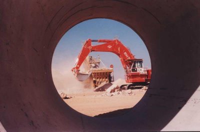
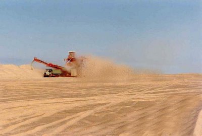
[Image: A new river is born, excavated from the surface of the desert: soon the pipes will be installed and the currents will start to flow…].