In the Box: A Tour Through the Simulated Battlefields of the U.S. National Training Center

[Image: Photo courtesy of Venue].

(This post originally published on Venue).

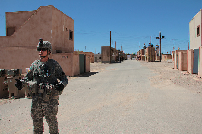
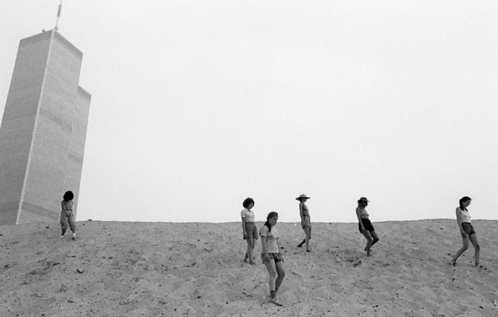
Fort Irwin is a U.S. army base nearly the size of Rhode Island, located in the Mojave Desert about an hour’s drive northeast of Barstow, California. There you will find the National Training Center, or NTC, at which all U.S. troops, from all services, spend a twenty-one day rotation before they deploy overseas.

[Image: Photo courtesy of Venue].

Sprawling and often infernally hot in the summer months, the base offers free tours, open to the public, twice a month. Venue—BLDGBLOG’s ongoing collaboration with Edible Geography’s Nicola Twilley, supported by the Nevada Museum of Art‘s Center for Art + Environment—made the trip, cameras in hand and notebooks at the ready, to learn more about the simulated battlefields in which imaginary conflicts loop, day after day, without end.

[Images: Photos courtesy of Venue].

Coincidentally, as we explored the Painted Rocks located just outside the gate while waiting for the tour to start, an old acquaintance from Los Angeles—architect and geographer Rick Miller—pulled up in his Prius, also early for the same tour.

[Image: Photo courtesy of Venue].

We laughed, said hello, and caught up about a class Rick had been teaching at UCLA about the military defense of L.A. during World War II, through to the present. An artificial battlefield, beyond even the furthest fringes of Los Angeles, Fort Irwin thus seemed like an appropriate place to meet.

[Image: Photo courtesy of Venue].

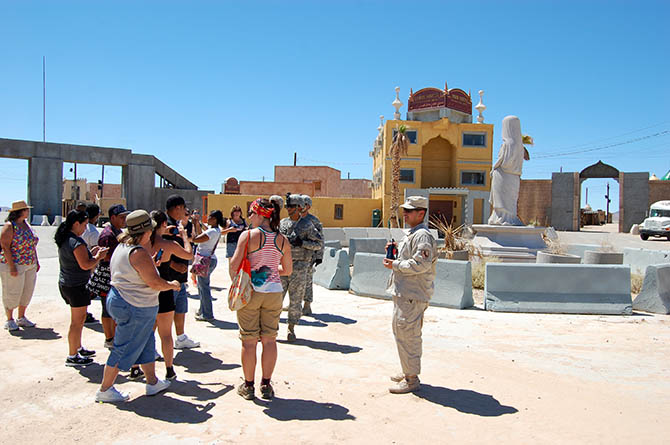
We were soon joined by a small group of other visitors—consisting, for the most part, of family members of soldiers deployed on the base, as well as two architecture students from Montréal—before a large white tour bus rolled up across the gravel.

Renita, a former combat videographer who now handles public affairs at Fort Irwin, took our names, IDs, and signatures for reasons of liability (we would be seeing live explosions and simulated gunfire, and there was always the risk that someone might get hurt).

[Image: Photo courtesy of Venue].

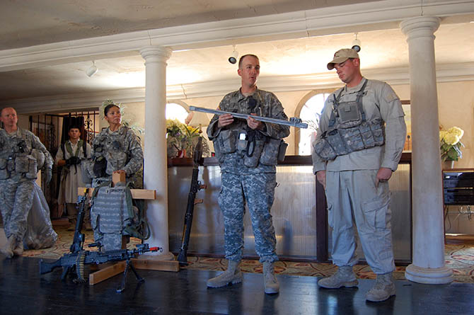
The day began with a glimpse into the economics and culture of how a nation prepares its soldiers for war; an orientation, of sorts, before we headed out to visit one of fifteen artificial cities scattered throughout the base.

[Image: Photo courtesy of Venue].

In the plush lecture hall used for “After Action Reviews”—and thus, Renita apologized, air-conditioned to a morgue-like chill in order to keep soldiers awake as their adrenalin levels crash—we received a briefing from the base’s commander, Brigadier General Terry Ferrell.

With pride, Ferrell noted that Fort Irwin is the only place where the U.S. military can train using all of the systems it will later use in theater. The base’s 1,000 square miles of desert is large enough to allow what Ferrell called “great maneuverability”; its airspace is restricted; and its truly remote location ensures an uncluttered electromagnetic spectrum, meaning that troops can practice both collection and jamming. These latter techniques even include interfering with GPS, providing they warn the Federal Aviation Administration in advance.

Oddly, it’s worth noting that Fort Irwin also houses the electromagnetically sensitive Goldstone Deep Space Communications Complex, part of NASA’s global Deep Space Network. As science writer Oliver Morton explains in a paper called “Moonshine and Glue: A Thirteen-Unit Guide to the Extreme Edge of Astrophysics” (PDF), “when digitized battalions slug it out with all the tools of modern warfare, radio, radar, and electronic warfare emissions fly as freely around Fort Irwin as bullets in a battle. For people listening to signals from distant spacecraft on pre-arranged frequency bands, this noise is not too much of a problem.” However, he adds, for other, far more sensitive experiments, “radio interference from the military next door is its biggest headache.”

[Image: Photo courtesy of Venue].

Unusually for the American West, where mineral rights are often transferred separately, the military also owns the ground beneath Fort Irwin, which means that they have carved out an extensive network of tunnels and caves from which to flush pretend insurgents.

This 120-person strong insurgent troop is drawn from the base’s own Blackhorse Regiment, a division of the U.S. Army that exists solely to provide opposition. Whatever the war, the 11th Armored is always the pretend enemy. According to Ferrell, their current role as Afghan rebels is widely envied: they receive specialized training (for example, in building IEDs) and are held to “reduced grooming standards,” while their mission is simply to “stay alive and wreak havoc.”

If they die during a NTC simulation, they have to shave and go back on detail on the base, Ferrell added, so the incentive to evade their American opponents is strong.

[Image: Photo courtesy of Venue].

In addition to the in-house enemy regiment, there is an entire 2,200-person logistics corps dedicated to rotating units in and out of Fort Irwin and equipping them for training. Every ordnance the United States military has, with the exception of biological and chemical weapons, is used during NTC simulations, Ferrell told us. What’s more, in the interests of realism (and expense be damned), troops train using their own equipment, which means that bringing in, for example, the 10th Mountain Division (on rotation during our visit), also means transporting their tanks and helicopters from their home base at Fort Drum, New York, to California, and back again.

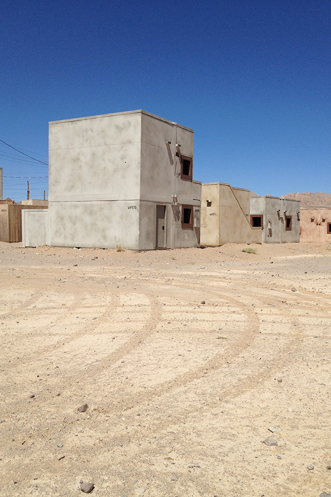
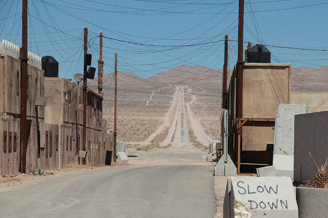
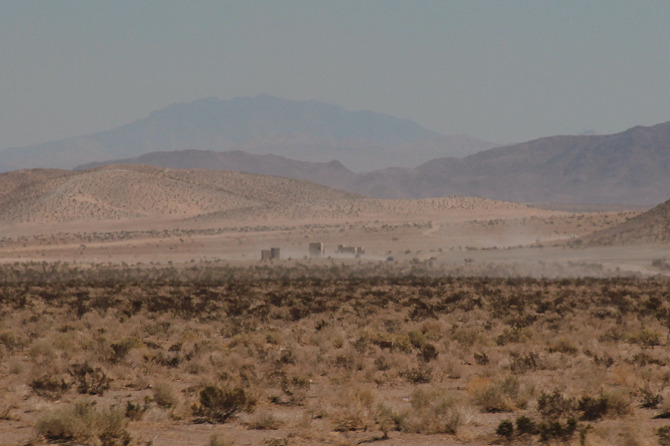
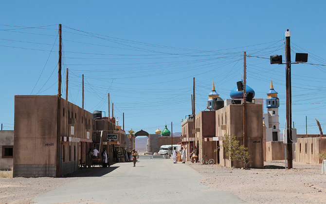
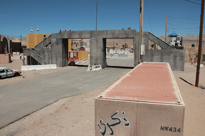
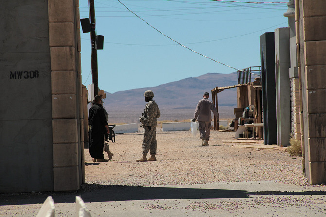
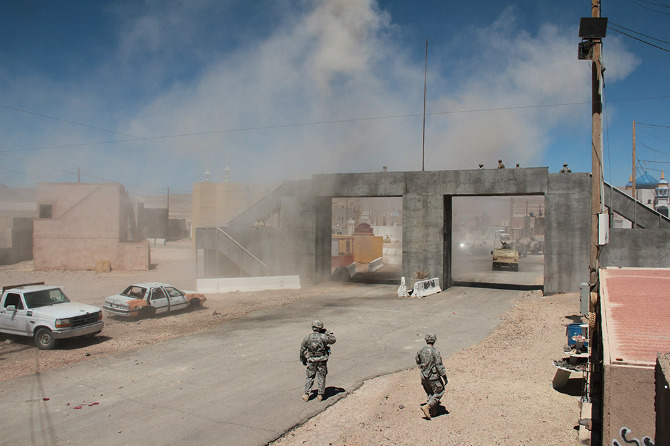
Units are deployed to Fort Irwin for twenty-one days, fourteen of which are spent in what Fort Irwin refers to as “The Box” (as in “sandbox”). This is the vast desert training area that includes fifteen simulated towns and the previously mentioned tunnel and caves, as well as expansive gunnery ranges and tank battle arenas.

Following our briefing, we headed out to the largest mock village in the complex, the Afghan town of Ertebat Shar, originally known, during its Iraqi incarnation, as Medina Wasl. Before we re-boarded the bus, Renita issued a stern warning: “‘Afghanistan’ is not modernized with plumbing. There are Porta-Johns, but I wanted to let you know the situation before we roll out there.”

[Images: Photos courtesy of Venue].

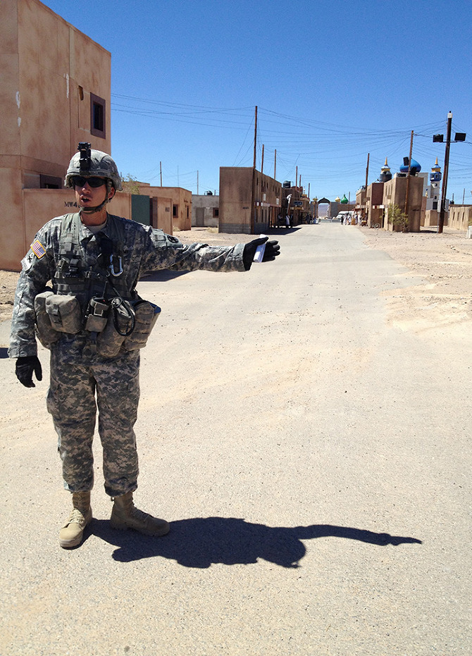
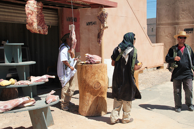
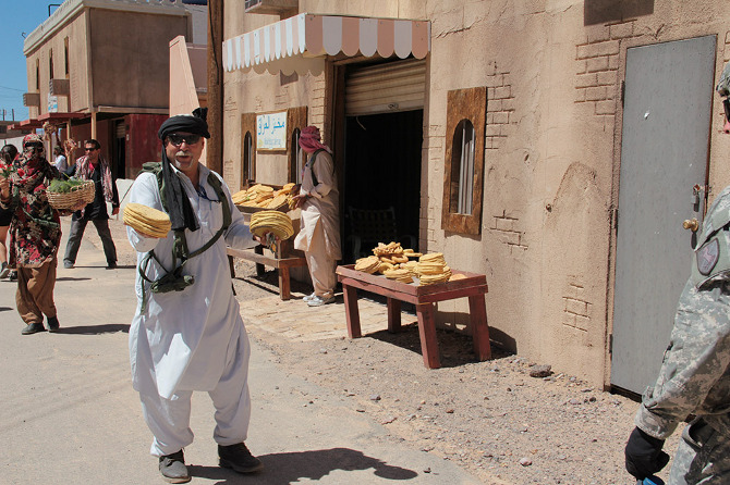
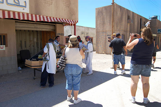
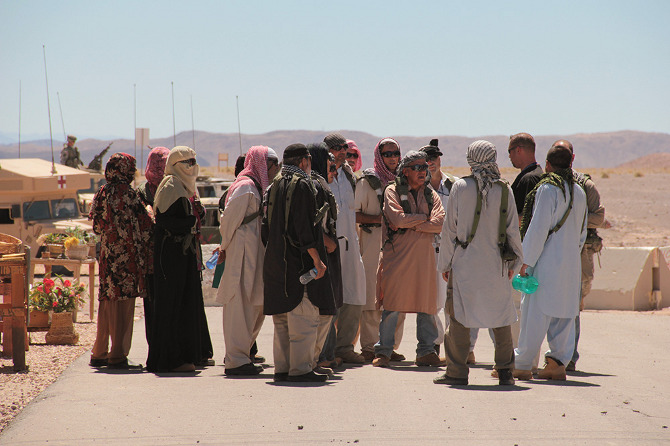
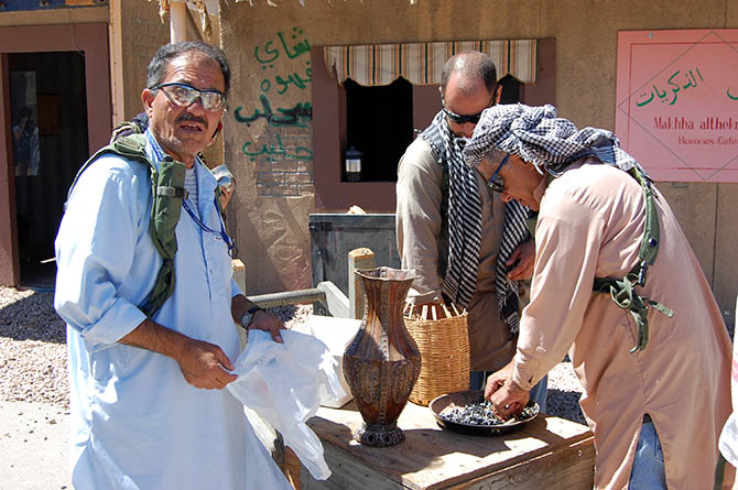
A twenty-minute drive later, through relatively featureless desert, our visit to “Afghanistan” began with a casual walk down the main street, where we were greeted by actors trying to sell us plastic loaves of bread and piles of fake meat. Fort Irwin employs more than 350 civilian role-players, many of whom are of Middle Eastern origin, although Ferrell explained that they are still trying to recruit more Afghans, in order “to provide the texture of the culture.”

The atmosphere is strangely good-natured, which was at least partially amplified by a feeling of mild embarrassment, as the rules of engagement, so to speak, are not immediately clear; you, the visitor, are obviously aware of the fact that these people are paid actors, but it feels distinctly odd to slip into character yourself and pretend that you might want to buy some bread.

[Images: Photos courtesy of Venue].

In fact, it’s impossible not to wonder how peculiar it must be for a refugee, or even a second-generation immigrant, from Iraq or Afghanistan, to pretend to be a baker in a simulated “native” village on a military base in the California desert, only to see tourists in shorts and sunglasses walking through, smiling uncomfortably and taking photos with their phones before strolling away without saying anything.

[Image: Photo courtesy of Venue].

Even more peculiarly, as we reached the end of the street, the market—and all the actors in it—vanished behind us, dispersing back into the fake city, as if only called into being by our presence.

[Image: Photo courtesy of Venue].

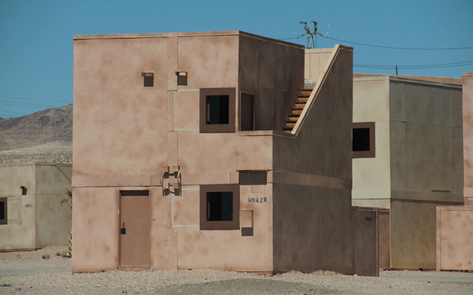
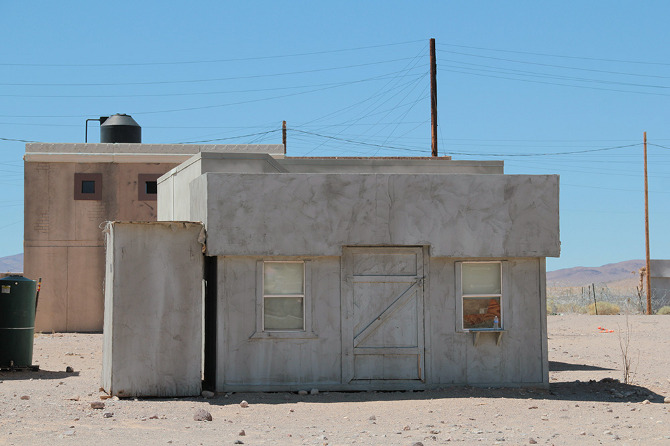
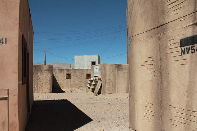
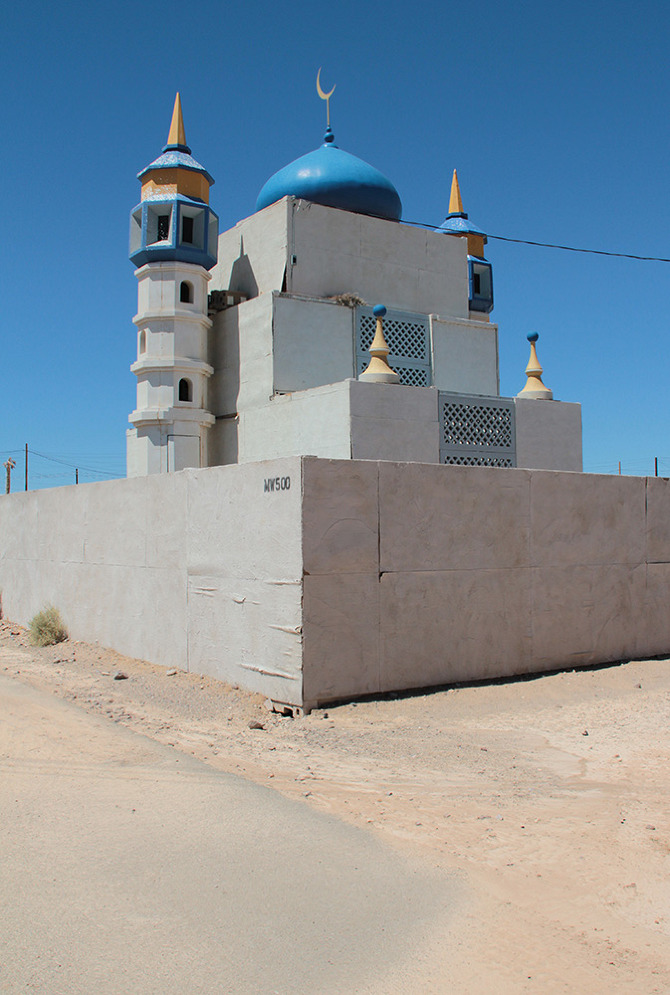
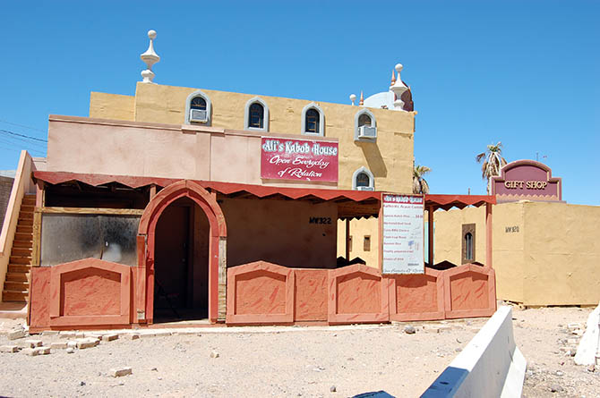
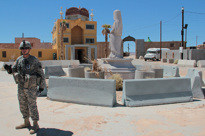
By now, with the opening act over, we were stopped in front of the town’s “Lyndon Marcus International Hotel” to take stock of our surroundings. In his earlier briefing, Ferrell had described the simulated villages’ close attention to detail—apparently, the footprint for the village came from actual satellite imagery of Baghdad, in order to accurately recreate street widths, and the step sizes inside buildings are Iraqi, rather than U.S., standard.

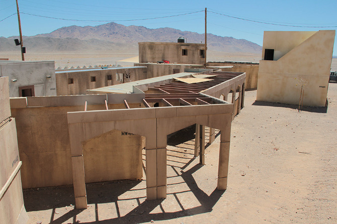
Dimensions notwithstanding, however, this is a city of cargo containers, their Orientalized facades slapped up and plastered on like make-up. Seen from above, the wooden frames of the illusion become visible and it becomes more and more clear that you are on a film set, an immersive theater of war.

[Images: Photos courtesy of Venue].

This kind of test village has a long history in U.S. war planning. As journalist Tom Vanderbilt writes in his book Survival City, “In March 1943, with bombing attacks on cities being intensified by all sides, the U.S. Army Corps of Engineers began construction at Dugway [Utah] on a series of ‘enemy villages,’ detailed reproductions of the typical housing found in the industrial districts of cities in Germany and Japan.”

The point of the villages at Dugway, however, was not to train soldiers in urban warfare—with, for instance, simulated street battles or house-to-house clearances —but simply to test the burn capacity of the structures themselves. What sorts of explosives should the U.S. use? How much damage would result? The attention to architectural detail was simply a subset of this larger, more violent inquiry. As Vanderbilt explains, bombs at Dugway “were tested as to their effectiveness against architecture: How well the bombs penetrated the roofs of buildings (without penetrating too far), where they lodged in the building, and the intensity of the resulting fire.”

During the Cold War, combat moved away from urban settings, and Fort Irwin’s desert sandbox became the stage for massive set-piece tank battles against the “Soviet” Blackhorse Cavalry. But, in 1993, following the embarrassment of the Black Hawk Down incident in Mogadishu, Fort Irwin hosted its first urban warfare, or MOUT (Military Operations on Urbanized Terrain) exercise. This response was part of a growing realization shared amongst the armed forces, national security experts, and military contractors that future wars would again take the city as their battlefield.

[Image: Photo courtesy of Venue].

As Russell W. Glenn of the RAND Corporation puts it bluntly in his report Combat in Hell: A Consideration of Constrained Urban Warfare, “Armed forces are ever more likely to fight in cities as the world becomes increasingly urbanized.”

Massed, professional, and essentially symmetrical armies no longer confront one another on the broad forests and plains of central Europe, the new tactical thinking goes; instead, undeclared combatants living beside—sometimes even with—families in stacked apartment blocks or tight-knit courtyards send out the occasional missile, bullet, or improvised explosive device from a logistically confusing tangle of streets, and “war” becomes the spatial process of determining how to respond.

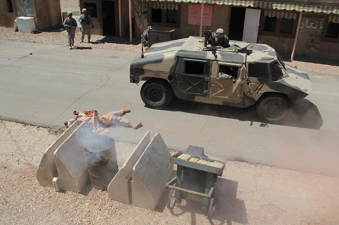
At Fort Irwin, mock villages began to pop up in the desert. They started out as “sheds bought from Shed World,” Ferrell told us, before being replaced by shipping containers, which, in turn, have been enhanced with stone siding, mosque domes, awnings, and street signs, and, in some cases, even with internal staircases and furniture, too. Indeed, Ertebat Shar/Medina Wasl began its simulated existence in 2007, with just thirteen buildings, but has since expanded to include more than two hundred structures.

The point of these architectural reproductions is no longer, as in the World War II test villages of Dugway, to find better or more efficient methods of architectural destruction; instead, these ersatz buildings and villages are used to equip troops to better navigate the complexity of urban structures—both physical, and, perhaps most importantly, socio-cultural.

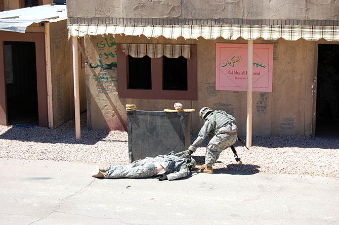
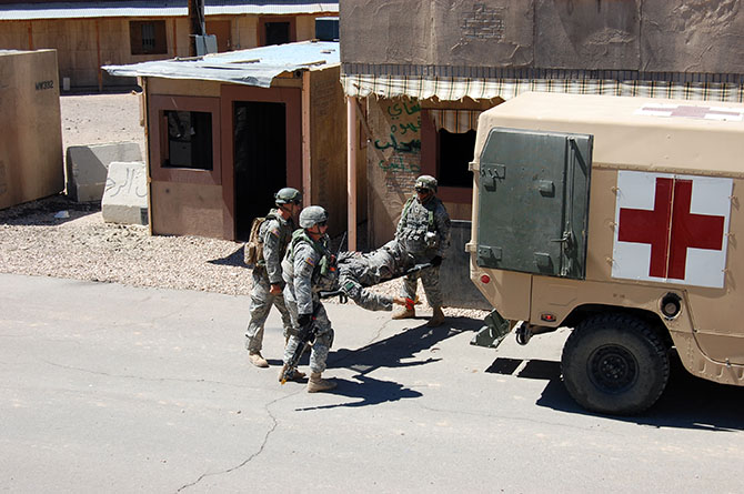
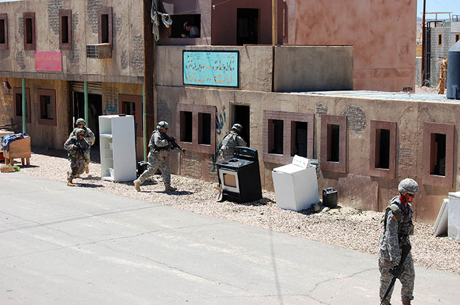
In other words, at the most basic level, soldiers will use Fort Irwin’s facsimile villages to practice clearing structures and navigating unmapped, roofed alleyways through cities without clear satellite communications links. However, at least in the training activities accessible to public visitors, the architecture is primarily a stage set for the theater of human relations: a backdrop for meeting and befriending locals (again, paid actors), controlling crowds (actors), rescuing casualties (Fort Irwin’s roster of eight amputees are its most highly paid actors, we learned, in recompense for being literally dragged around during simulated combat operations), and, ultimately, locating and eliminating the bad guys (the Blackhorse regiment).

[Image: Photo courtesy of Venue].

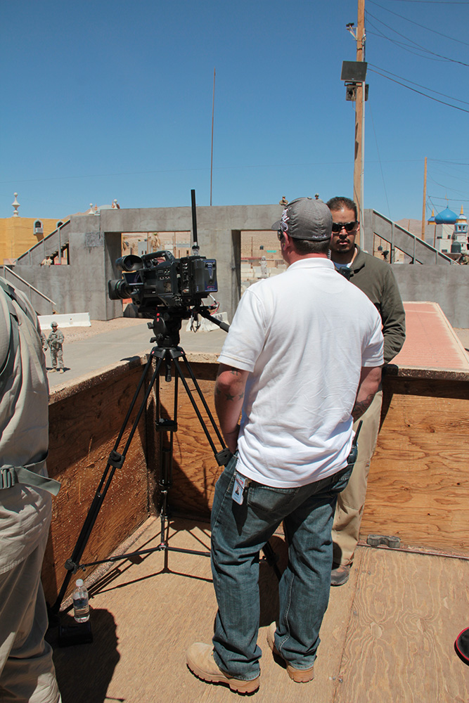
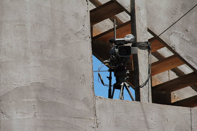
In the series of set-piece training exercises that take place within the village, the action is coordinated from above by a ring of walkie-talkie connected scenographers, including an extensive internal media presence, who film all of the simulations for later replay in combat analysis. The sense of being on an elaborate, extremely detailed film set is here made explicit. In fact, visitors are openly encouraged to participate in this mediation of the events: we were repeatedly urged to take as many photographs as possible and to share the resulting images on Facebook, Twitter, and more.

[Images: Photos courtesy of Venue].

Appropriately equipped with ear plugs and eye protection, we filed upstairs to a veranda overlooking one of the village’s main throughways, where we joined the “Observer Coaches” and film crew, taking our positions for the afternoon’s scripted exercise.

[Image: Photo courtesy of Venue].

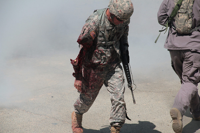
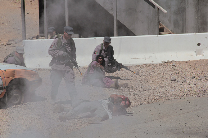
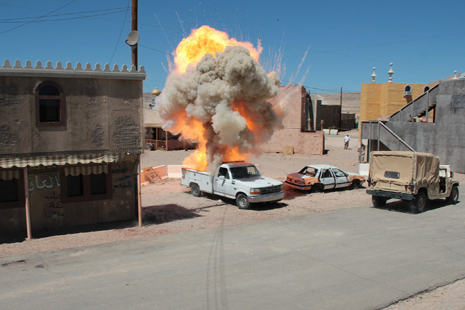
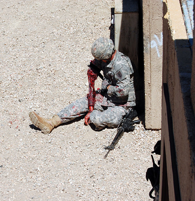
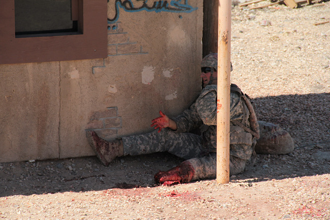
Loud explosions, smoke, and fairly grisly combat scenes ensued—and thus, despite their simulated nature, involving Hollywood-style prosthetics and fake blood, please be warned that many of the forthcoming photos could still be quite upsetting for some viewers.

[Images: Photos courtesy of Venue].

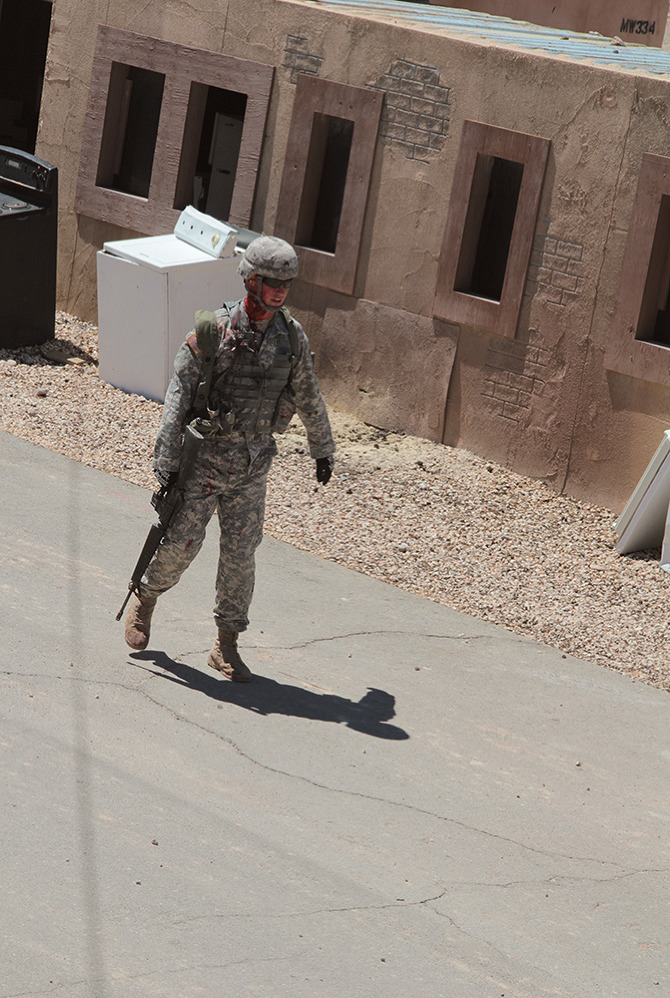
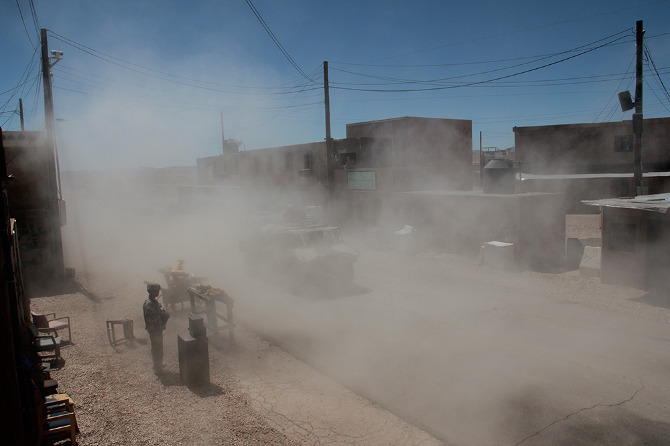
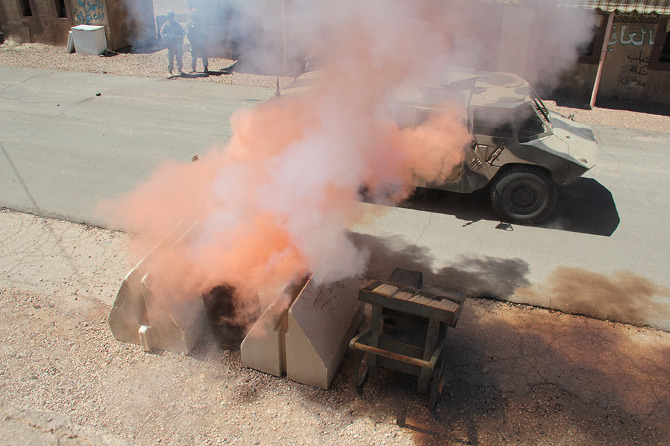
The afternoon’s action began quietly enough, with an American soldier on patrol waving off a man trying to sell him a melon. Suddenly, a truck bomb detonated, smoke filled the air, and an injured woman began to wail, while a soldier slumped against a wall, applying a tourniquet to his own severed arm.

[Images: Photos courtesy of Venue].

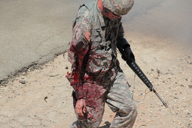
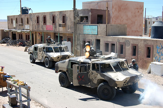
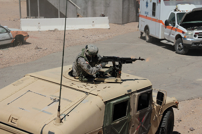
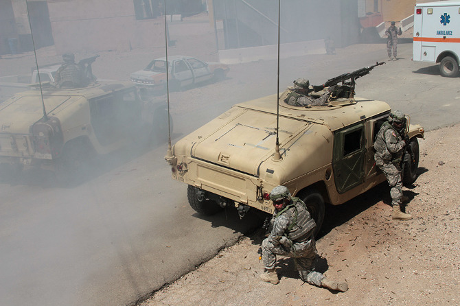
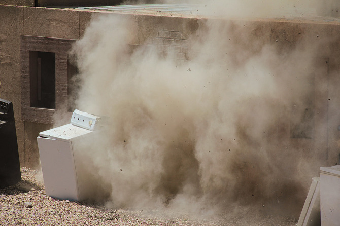
In the subsequent chaos, it was hard to tell who was doing what, and why: gun trucks began rolling down the streets, dodging a live goat and letting off round after round as insurgents fired RPGs (mounted on invisible fishing line that blended in with the electrical wires above our heads) from upstairs windows; blood-covered casualties were loaded into an ambulance while soldiers went door-to-door with their weapons drawn; and, in the episode’s climax, a suicide bomber blew himself up directly beneath us, showering our tour group with ashes.

[Images: Photos courtesy of Venue].

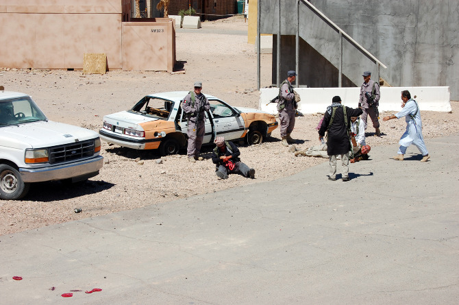
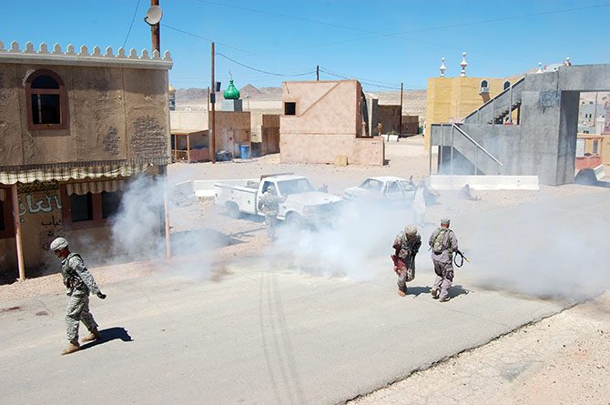
Twenty minutes later, it was all over. The smoke died down; the actors reassembled, uninjured, to discuss what just occurred; and the sound of blank rounds being fired off behind the buildings at the end of the exercise echoed through the streets.

[Image: Photo courtesy of Venue].

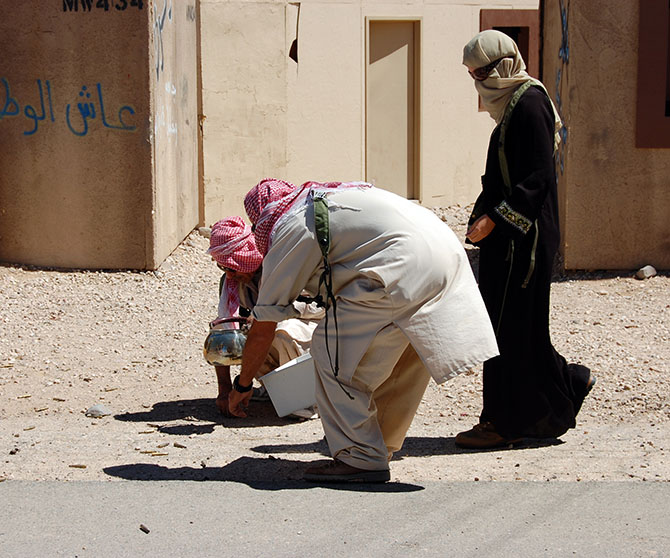
Incredibly, blank rounds assigned to a particular exercise must be used during that exercise and cannot be saved for another day; if you are curious as to where your tax dollars might be going, picture paid actors shooting entire magazines full of blank rounds out of machine guns behind simulated Middle Eastern buildings in the Mojave desert. Every single blank must be accounted for, leading to the peculiar sight of a village’s worth of insurgents stooped, gathering used blank casings into their prop kettles, bread baskets, and plastic bags.

[Images: Photos courtesy of Venue].

Finally, we descended back down onto the street, dazed, ears ringing, and a little shocked by all the explosions and gunfire. Stepping carefully around pools of fake blood and chunks of plastic viscera, we made our way back to the lobby of the International Hotel for cups of water and a debrief with soldiers involved in planning and implementing the simulation.

[Image: Photo courtesy of Venue].

Our hosts there were an interesting mix of earnest young boys who looked like they had successful careers in politics ahead of them, standing beside older men, almost stereotypically hard-faced, who could probably scare an AK-47 into misfiring just by staring at it, and a few female soldiers.

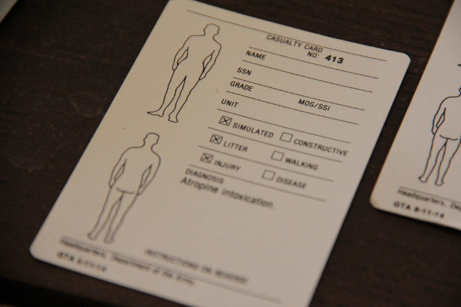
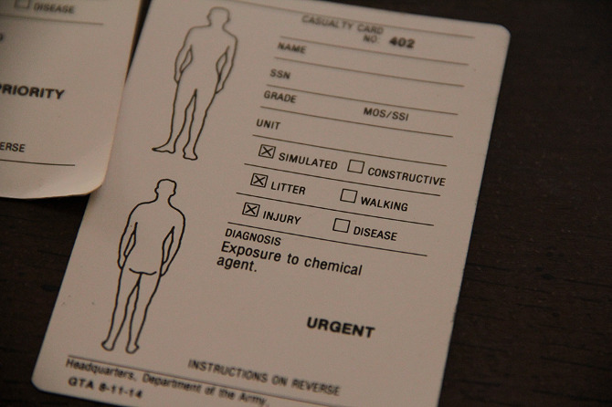
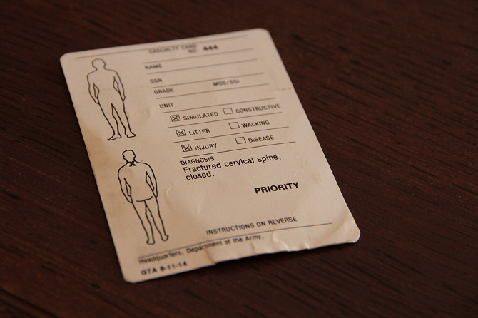
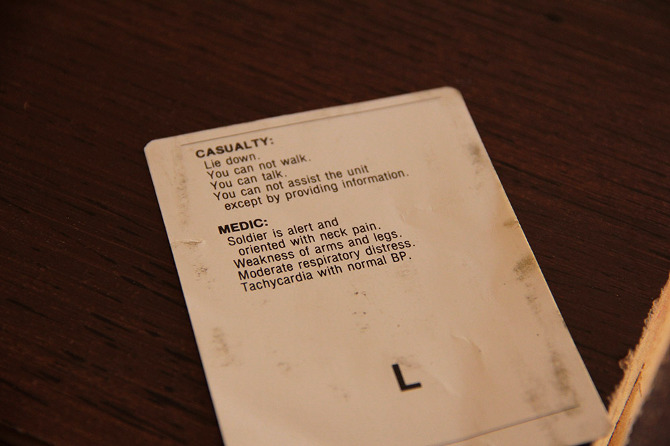
Somewhat subdued at this point, our group sat on sofas that had seen better days and passed around an extraordinary collection of injury cards handed out to fallen soldiers and civilians. These detail the specific rules given for role-playing a suite of symptoms and behavior—a kind of design fiction of military injury.

[Images: Photos courtesy of Venue].

A few of us tried on the MILES (Multiple Integrated Laser Engagement System) harnesses that soldiers wear to sense hits from fired blanks, and then an enemy soldier demonstrated an exploding door sill.

[Images: Photos courtesy of Venue].

While the film crew and Observer Coaches prepared for their “After Action Review,” our guides seemed talkative but unwilling to discuss how well or badly the afternoon’s session had gone. We asked, instead, about the future of Fort Irwin’s villages, as the U.S. withdraws from Afghanistan. The vision is to expand the range of urban conditions into what Ferrell termed a “Decisive Action Training Environment,” in which U.S. military will continue to encounter “the world’s worst actors” [sic]—”guerrillas, criminals, and insurgents”—amidst the furniture of city life.

As he escorted us back down the market street to our bus, one soldier off-handedly remarked that he’d heard the village might be redesigned soon as a Spanish-speaking environment—before hastily and somewhat nervously adding that he didn’t know for sure, and, anyway, it probably wasn’t true.

[Image: Photo courtesy of Venue].

The “town” is visible on Google Maps, if you’re curious, and it is easy to reach from Barstow. Tours of “The Box” are run twice a month and fill up quickly; learn more at the Fort Irwin website, including safety tips and age restrictions.

• • •

For more Venue content, exploring human interactions with the built, natural, and virtual environments through 16 months of travel around the continental United States, check out the Venue website in full.

Skyfall

Although the Earth itself will be coming to its fiery and magmatic end in 7 billion years’ time, its nighttime skies will be undergoing an extraordinary slow-motion light-show: the merging of the Milky Way and Andromeda galaxies.

An animation released last summer by NASA, called “What the Night Sky Will Look Like Over the Next 7 Billion Years” and embedded above, depicts the glowing filaments of these two galaxies, like plate tectonics in space, crashing together, gravitationally distorting one another, and then merging in a featureless cloud of light.

[Image: Via HubbleSite].

In his weird, brilliant, and unimaginably dense book The Invention of the Zero poet Richard Kenney exclaims, “Imagine, all new constellations! …a seethe / and flume of unfamiliar skies.”

But such skies are not merely the domain of speculative poetry, as they are, in fact, on their way, roiling toward us in billion-year-long collisions that we, as a species, will never see the true light of.

[Image: Via HubbleSite].

I’m reminded of an essay by geologist Steven Dutch, at the University of Wisconsin, Green Bay, called “The Earth Has A Future,” originally published in the May 2006 issue of Geosphere.

Advocating what he calls a “futurist approach” to the planetary sciences, Dutch points out that “a million years is relatively short in geologic terms. For example, even the fastest plates, moving on the order of 15 cm/yr, will have moved only 150 km in a million years, enough to have very significant local geological effects but scarcely enough to be casually noticeable on a globe.”

However, Dutch’s “futurist approach” to landscape studies becomes particularly fascinating when he turns his attention upward, to the sky, looking out beyond the Earth to what stars and their constellations might look like in roughly one million years. Dutch predicts, for instance, that “distant star patterns like Orion should be recognizable” for several hundred thousand years, “but many constellations will have changed noticeably.”

In other words, the sky is always—even now—adrift, already fulfilling Kenney’s “seethe and flume of unfamiliar skies.”

[Image: Via HubbleSite].

But that’s just a million years. Multiply that by seven-and-a-half thousand, and the heavenly distortions torquing through the skies above us become magical even to contemplate.

(Related: Pruned‘s Proposal for an Ideas Competition Seeking Design Proposals for a Pavilion for Viewing the Coming Intergalactic Collision between Andromeda and the Milky Way).

Eyeball

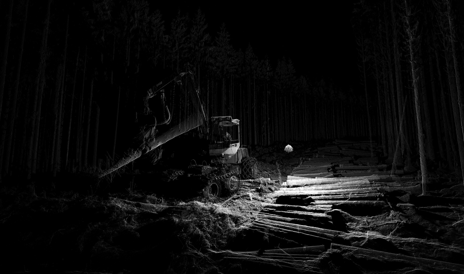
[Image: The throwable eyeball from Bounce Imaging].

A throwable building-mapping sphere from Bounce Imaging was recently chosen by PopSci for a 2013 Invention Award. The “throwable, expendable, baseball-size probe,” in PopSci‘s words, “has a shock-absorbing shell embedded with six cameras, plus clusters of near-infrared LEDs to light up dark rooms (for the cameras).”

To deploy the Explorer, an emergency worker links it to a smartphone or tablet and chucks the ball into danger. It immediately begins taking photos and testing for methane, carbon monoxide, and dangerously high temperatures. A microprocessor inside the ball then stiches the photos together and converts the raw data for transmission over Wi-Fi. Just seconds after the toss, a wrap-around panorama—complete with environmental warnings—appears on the synced device.

The usefulness of this as a tool for cave mapping, or even as a new piece of kit for semi-autonomous, non-destructive archaeological investigations, seems both obvious and worth tracking in the future.

Unsurprisingly, however, the MIT Technology Review points out that the “ball-sized device could be particularly useful for the military,” as it is lightweight, extremely portable, and, because of its low cost, it “could be abandoned, if necessary.” Teams of soldiers, arriving at a building or city of which no accurate maps or floorplans exist, could thus toss these little baseball-like devices into the darkness ahead and achieve tactical awareness within seconds–unless, of course, WiFi-hijacking counter-measures send back deliberately incorrect plans and layouts to the unsuspecting soldiers.

Warfare, here, would become a weird sort of architectural sorcery, casting spatial spells on one another, broadcasting ghosts and mirages to the screens of an approaching enemy.

Bounce Imaging‘s research is interesting to put into the context of another building-mapping project currently underway at MIT: Maurice Fallon’s “automatic building mapping” project—

—which functions by way of a wearable LiDAR pack, sort of like a forward-scanning Iron Man chest piece, that allows for real-time mapping of a structure’s internal layout.

As you can see in the above video, though, the design aesthetic of the scanning pack is, at least right now, workaday and extremely pragmatic; I would thus love to see what students from, for example, the Design Interactions department at London’s Royal College of Art could do with it, putting together a shell or housing unit for the scanner itself. Take a look at the recently all-over-the-internet project called Eidos, by which RCA students promise to “sharpen your senses” through a set of beautifully-made wearable devices.

[Image: Part of the Eidos system by RCA students Tim Bouckley, Millie Clive-Smith, Mi Eun Kim, and Yuta Sugawara].

But I’ll leave this for now, as a forthcoming interview soon to be published over at Venue, with Georgia Tech roboticist Henrik Christensen, picks up many of these threads with great interest.

The Extinction Orchestra

[Images: From Marguerite Humeau‘s Opera of Prehistoric Creatures; photos by Stuart Bailes and Felipe Ribon].

Designer Marguerite Humeau reconstructs the voices of extinct animals based on speculative extrapolations from their skull structure.

As she described her work in an interview with We Make Money Not Art last month, the project is an attempt “to resuscitate the sound of prehistoric creatures by reconstructing their vocal tracts,” casting large resonation chambers that then whistle, bleat, bellow, and moan, offering fictionalized bodily soundtracks for multi-million year-old landscapes.

Appropriately called The Opera of Prehistoric Creatures, it includes sonic reconstructions of three species of extinct mega-fauna, including the Ambulocetus, or “Walking Whale,” an Entelodont, or the terrifying-sounding “Terminator Pig,” and a Mammoth Imperator.

[Images: From Marguerite Humeau‘s Opera of Prehistoric Creatures; photos by Felipe Ribon Dirk van den Heuvel].

Partial reconstructions of their skeletons, combined with the speculative sounds of their long-lost calls, form what Humeau calls “semi-real, synthetic ruins.” They stand like bleached monuments in the gallery space: resurrected animal bodies singing dead songs for the 21st century.

Briefly, and unrelatedly, I’m reminded of the extraordinary point made in Adrienne Mayor’s fantastic book The First Fossil Hunters, where we read that one of the reasons for ancient myths of cyclops, giants, and titans was, in effect, bad paleontology. In other words, the ancient Greeks and other civilizations around the Mediterranean simply got their fossils wrong, reconstructing old bones not as the mammoths they really were—

[Image: From The First Fossil Hunters by Adrienne Mayor].

—but as truly massive, humanoid forms with odd, singular holes in the middles of their skulls (actually a nostril, not a cyclops eye), lording over tiny humans who quaked miserably beside them.

[Image: From The First Fossil Hunters by Adrienne Mayor].

In any case, you can listen to Marguerite Humeau’s soundscape of extinct animal calls here.

Then he heard the ice coming

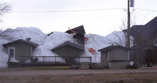
[Image: “The ice is up taller than the cottages and homes,” we read. “It kind of dwarfs them.” Photo and quotation via the Winnipeg Free Press].

Several houses were destroyed, the Winnipeg Free Press reports, after “a massive ice floe rose out of Dauphin Lake” in central Canada. One local homeowner described the ice’s arrival as “so powerful that it plowed though his two-storey home, pushing furniture from one bedroom into another. It pushed the bathroom tub and vanity into the hallway.”

This kind of reverse-Titanic moment occurred just as the gentleman had sat down to watch TV: “Then he heard the ice coming.”

In fact, one wonders, if this were to become an annual event, how houses might be adapted to account for it, similar to John McPhee’s descriptions of the altered suburbs of Los Angeles, where garage doors have been repurposed to let mountain landslides pass safely through. You pop open some doors and shutters, or deploy emergency stilts, and the ice slides quietly by, your lakeside home unviolated.

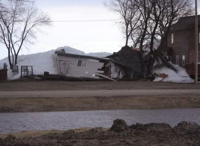
[Image: “This is nothing you can predict,” one homeowner said. “There’s nothing you can do to prevent this.” Photo and quotation via the
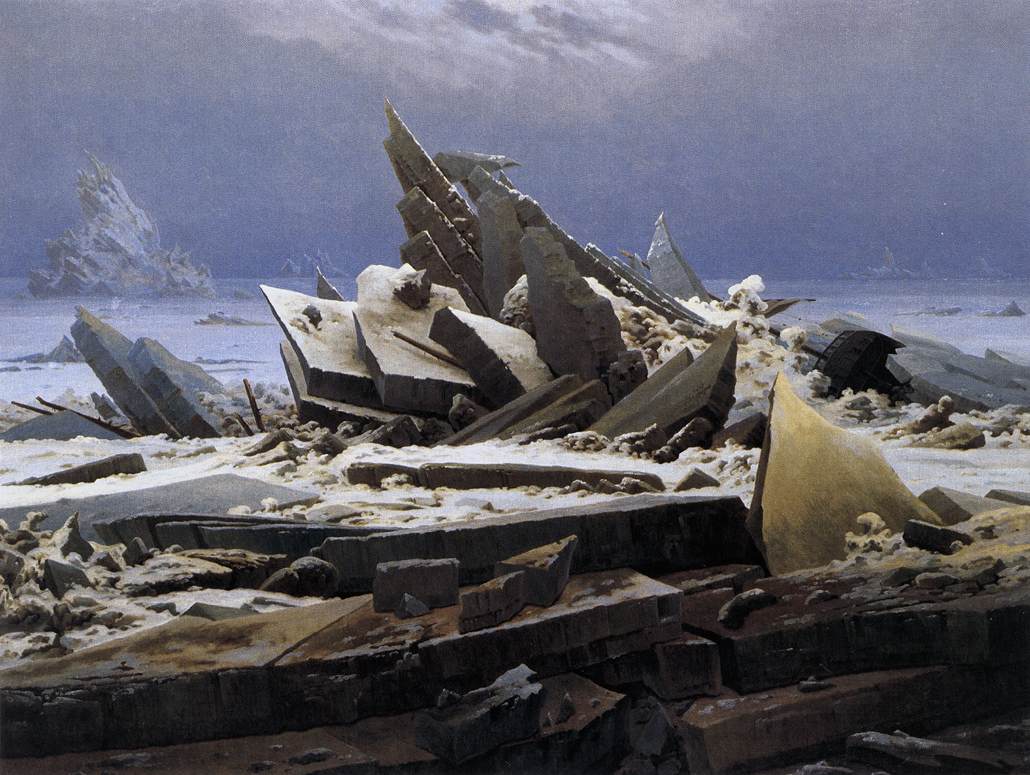
 Winnipeg Free Press].

The photos also show what it might look like if an ice age were to kick off again in the North American suburbs, with massive walls of ice simultaneously crushing houses from all sides and bursting them from within, like Caspar David Friedrich’s Sea of Ice crossed with an unpublished novella by J.G. Ballard.

[Image: The Sea of Ice by Caspar David Friedrich].

The Great Plains of America filled with jagged labyrinths of ice, their peaks and troughs littered not with the timber of shipwrecks but with the split wooden frames of abandoned houses.

(Thanks to Lawrence Bird for the tip! Randomly related: Floating islands gone wild.)

Sim City: An Interview with Stone Librande

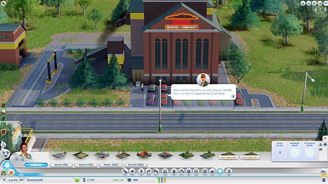
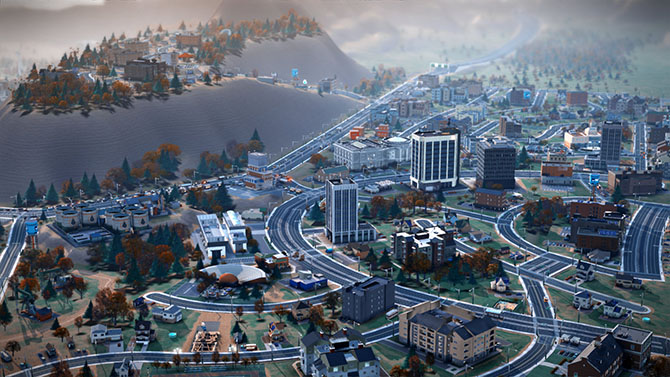
[Image: Screenshot of our own SimCity—called, for reasons that made sense at the time, We Are The Champignons—after three hours of game play].

(This interview was originally published on Venue).

In the nearly quarter-century since designer Will Wright launched the iconic urban planning computer game, SimCity, not only has the world’s population become majoritatively urban for the first time in human history, but interest in cities and their design has gone mainstream.

Once a byword for boring, city planning is now a hot topic, claimed by technology companies, economists, so-called “Supermayors,” and cultural institutions alike as the key to humanity’s future. Indeed, if we are to believe the hype, the city has become our species’ greatest triumph.

[Image: A shot from photographer Michael Wolf‘s extraordinary Architecture of Density series, newly available in hardcover].

In March 2013, the first new iteration of SimCity in a decade was launched, amidst a flurry of critical praise mingled with fan disappointment at Electronic Arts’ “always-online” digital rights management policy and repeated server failures.

A few weeks before the launch, Venue—BLDGBLOG’s ongoing collaboration with Edible Geography‘s Nicola Twilley, supported by the Nevada Museum of Art‘s Center for Art + Environment—had the opportunity to play the new SimCity at its Manhattan premiere, during which time we feverishly laid out curving roads and parks, drilled for oil while installing a token wind turbine, and tried to ignore our city’s residents’—known as Sims—complaints as their homes burned before we could afford to build a fire station.


We emerged three hours later, blinking and dazed, into the gleaming white and purple lights of Times Square, and were immediately struck by the intensity of abstraction required to translate such a complex, dynamic environment into a coherent game structure, and the assumptions and values embedded in that translation.

Fortunately, the game’s lead designer, Stone Librande, was happy to talk with us further about his research and decision-making process, as well as some of the ways in which real-world players have already surprised him. We spoke to him both in person and by telephone, and our conversation appears below.

• • •


Nicola Twilley: I thought I’d start by asking what sorts of sources you used to get ideas for SimCity, whether it be reading books, interviewing urban experts, or visiting different cities?

Stone Librande: From working on SimCity games in the past, we already have a library here with a lot of city planning books. Those were really good as a reference, but I found, personally, that the thing I was most attracted to was using Google Earth and Google Street View to go anywhere in the world and look down on real cities. I found it to be an extremely powerful way to understand the differences between cities and small towns in different regions.

Google has a tool in there that you can use to measure out how big things are. When I first started out, I used that a lot to investigate different cities. I’d bring up San Francisco and measure the parks and the streets, and then I’d go to my home town and measure it, to figure out how it differed and so on. My inspiration wasn’t really drawn from urban planning books; it was more from deconstructing the existing world.

Then I also really got into Netflix streaming documentaries. There is just so much good stuff there, and Netflix is good at suggesting things. That opened up a whole series of documentaries that I would watch almost every night after dinner. There were videos on water problems, oil problems, the food industry, manufacturing, sewage systems, and on and on—all sorts of things. Those covered a lot of different territory and were really enlightening to me.


Geoff Manaugh: While you were making those measurements of different real-world cities, did you discover any surprising patterns or spatial relationships?

Librande: Yes, definitely. I think the biggest one was the parking lots. When I started measuring out our local grocery store, which I don’t think of as being that big, I was blown away by how much more space was parking lot rather than actual store. That was kind of a problem, because we were originally just going to model real cities, but we quickly realized there were way too many parking lots in the real world and that our game was going to be really boring if it was proportional in terms of parking lots.

Manaugh: You would be making SimParkingLot, rather than SimCity.

Librande: [laughs] Exactly. So what we do in the game is that we just imagine they are underground. We do have parking lots in the game, and we do try to scale them—so, if you have a little grocery store, we’ll put six or seven parking spots on the side, and, if you have a big convention center or a big pro stadium, they’ll have what seem like really big lots—but they’re nowhere near what a real grocery store or pro stadium would have. We had to do the best we could do and still make the game look attractive.

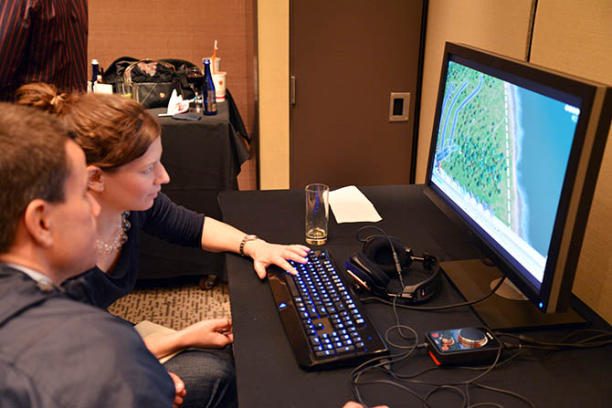
[Image: Using the zoning tool for the city designed by We Are the Champignons].

Twilley: I’d love to hear more about the design process and how you went about testing different iterations. Did you storyboard narratives for possible cities and urban forms that you might want to include in the game?

Librande: The way the game is set up, it’s kind of infinite. What I mean by that is that you could play it so many different ways that it’s basically impossible to storyboard or have a defined set of narratives for how the player will play it.

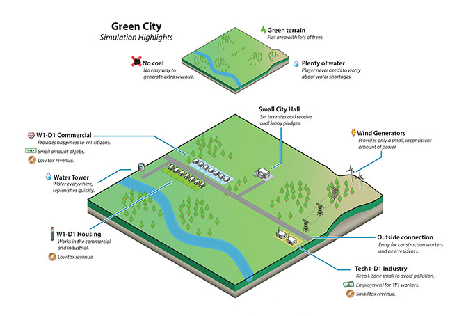
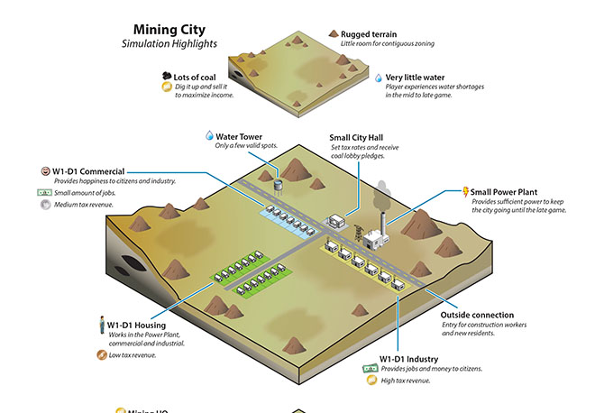
[Images: Stone Librande’s storyboards for “Green City” and “Mining City” at the start of play].

Instead, what I did was that I came up with two extreme cases—around the office we call them “Berkeley” and “Pittsburgh,” or “Green City” and “Dirty City.” We said, if you are the kind of player who wants to make utopia—a city with wind power, solar power, lots of education and culture, and everything’s beautiful and green and low density—then this would be the path you would take in our game.

But then we made a parallel path for a really greedy player who just wants to make as much money as possible, and is just exploiting or even torturing their Sims. In that scenario, you’re not educating them; you’re just using them as slave labor to make money for your city. You put coal power plants in, you put dumps everywhere, and you don’t care about their health.

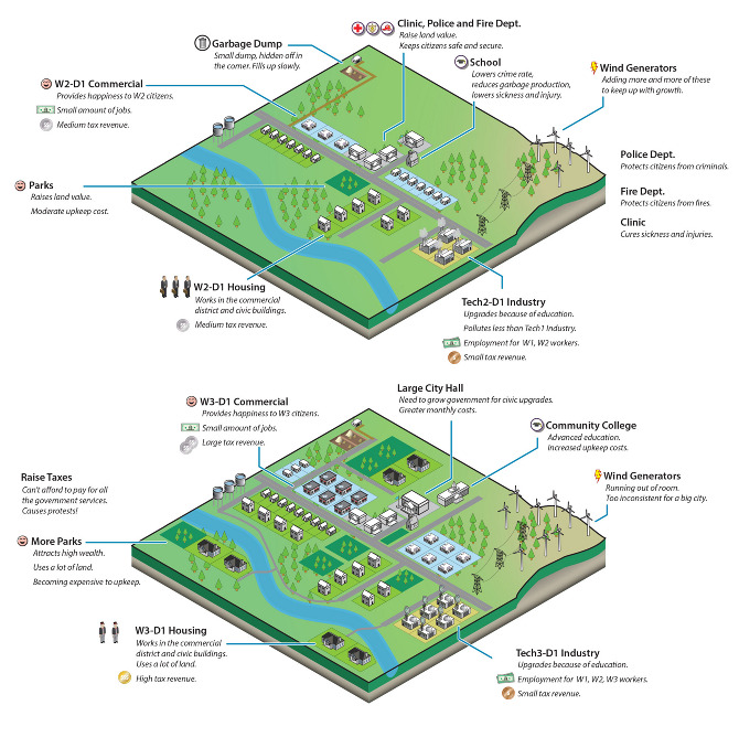
[Image: Stone Librande’s storyboard for “Green City” at mid-game].

I made a series of panels, showing those two cities from beginning to late stage, where everything falls apart. Then, later on, when we got to multiplayer, I joined those two diagrams together and said, “If both of these cities start working together, then they can actually solve each other’s problems.”

The idea was to set them up like bookends—these are the extremes of our game. A real player will do a thousand things that fall somewhere in between those extremes and create all sorts of weird combinations. We can’t predict all of that.

Basically, we figured that if we set the bookends, then we would at least understand the boundaries of what kind of art we need to build, and what kind of game play experiences we need to design for.

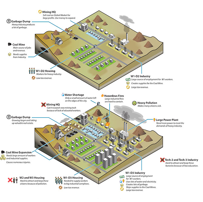
[Image: Stone Librande’s storyboard for “Mining City” at mid-game].

Twilley: In going through that process, did you discover things that you needed to change to make game play more gripping for either the dirty city or the clean city?

Librande: It was pretty straightforward to look at Pittsburgh, the dirty city, and understand why it was going to fail, but you have to try to understand why the clean one might fail, as well. If you have one city—one path—that always fails, and one that always succeeds, in a video game, that’s really bad design. Each path has to have its own unique problems.

What happened was that we just started to look at the two diagrams side-by-side, and we knew all the systems we wanted to support in our game—things like power, utilities, wealth levels, population numbers, and all that kind of stuff—and we basically divided them up.

We literally said: “Let’s put all of this on this side over in Pittsburgh and the rest of it over onto Berkeley.” That’s why, at the very end, when they join together, they are able to solve each other’s problems because, between the two of them, they have all the problems but they also have all the answers.

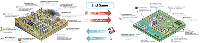
[Image: Stone Librande’s storyboard for the “Green City” and “Mining City” end-game symbiosis].

Twilley: One thing that struck me, after playing, was that you do incorporate a lot of different and complex systems in the game, both physical ones like water, and more abstract ones, like the economy. But—and this seems particularly surprising, given that one of your bookend cities was nicknamed Berkeley—the food system doesn’t come into the game at all. Why not?

Librande: Food isn’t in the game, but it’s not that we didn’t think about it—it just became a scoping issue. The early design actually did call for agriculture and food systems, but, as part of the natural process of creating a video game, or any situation where you have deadlines and budgets that you have to meet, we had to make the decision that it was going to be one of the things that the Sims take care of on their own, and that the Mayor—that is, the player—has nothing to do with it.

I watched some amazing food system documentaries, though, so it was really kind of sad to not include any of that in the game.

[Image: Data layer showing ore deposits].

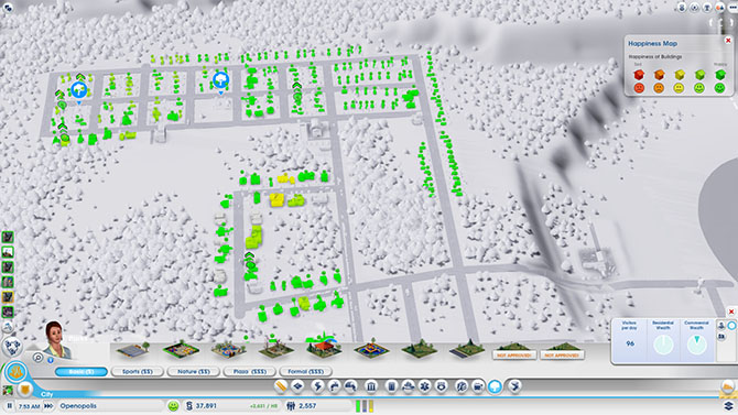
[Image: Data layer showing happiness levels. In SimCity, happiness is increased by wealth, good road connections, and public safety, and decreased by traffic jams and pollution].

Manaugh: Now that the game is out in the world, and because of the central, online hosting of all the games being played right now, I have to imagine that you are building up an incredible archive of all the decisions that different players have made and all the different kind of cities that people have built. I’m curious as to what you might be able to make or do with that kind of information. Are you mining it to see what kinds of mistakes people routinely make, or what sorts of urban forms are most popular? If so, is the audience for that information only in-house, for developing future versions of SimCity, or could you imagine sharing it with urban planners or real-life Mayors to offer an insight into popular urbanism?

Librande: It’s an interesting question. It’s hard to answer easily, though, because there are so many different ways players can play the game. The game was designed to cover as many different play patterns as we could think of, because our goal was to try to entertain as many of the different player demographics as we could.

So, there are what we call “hardcore players.” Primarily, they want to compete, so we give them leader boards and we give them incentives to show they are “better” than somebody else. We might say: “There’s a competition to have the most people in your city.” And they are just going to do whatever it takes to cram as many people into a city as possible, to show that they can win. Or there might be a competition to get the most rich people in your city, which requires a different strategy than just having the most people. It’s hard to keep rich people in a city.

Each of those leader boards, and each of those challenges, will start to skew those hardcore people to play in different ways. We are putting the carrot out there and saying: “Hey, play this way and see how well you can do.” So, in that case, we are kind of tainting the data, because we are giving them a particular direction to go in and a particular goal.

On the other end of the spectrum, there are the “creative players” who are not trying to win—they are trying to tell a story. They are just trying to create something beautiful. For instance, when my wife plays, she wants lots of schools and parks and she’s not at all concerned with trying to make the most money or have the most people. She just wants to build that idealized little town that she thinks would be the perfect place to live.

[Image: A regional view of a SimCity game, showing different cities and their painfully small footprints].

So, getting back to your question, because player types cover such a big spectrum, it’s really hard for us to look at the raw data and pull out things like: “This is the kind of place that people want to live in.” That said, we do have a lot of data and we can look at it and see things, like how many people put down a park and how many people put in a tram system. We can measure those things in the aggregate, but I don’t think they would say much about real city planning.

Twilley: Building on that idea of different sorts of players and ways of playing, are there a variety of ways of “winning” at SimCity? Have you personally built cities that you would define as particularly successful within the game, and, if so, what made them “winners”?

Librande: For sure, there is no way to win at SimCity other then what you decide to put into the game. If you come in with a certain goal in mind—perhaps, say, that you want a high approval rating and everyone should be happy all the time— then you would play very differently than if you went in wanting to make a million dollars or have a city with a million people in it.

As far as my personal city planning goes, it has varied. I’ve played the game so much, because early on I just had to play every system at least once to understand it. I tried to build a power city, a casino city, a mining city—I tried to build one of everything.

Now that I’m done with that phase, and I’m just playing for fun at home, I’ve learned that I enjoy mid-density cities much more then high-density cities. To me, high-density cities are just a nightmare to run and operate. I don’t want to be the mayor of New York; I want to be the mayor of a small town. The job is a lot easier!

Basically, I build in such a way as to not make skyscrapers. At the most, I might have just one or two because they look cool—but that’s it.

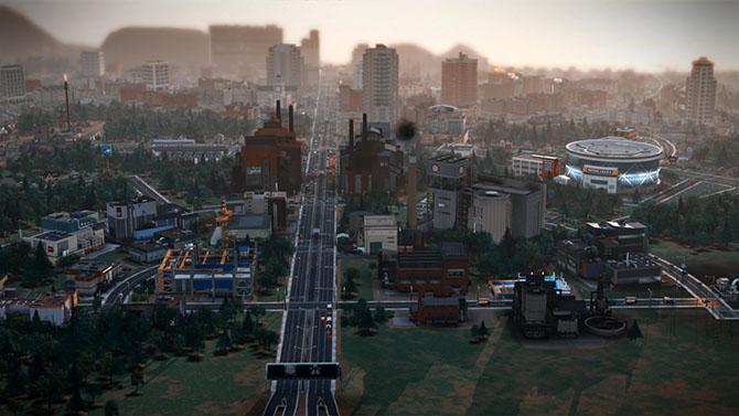
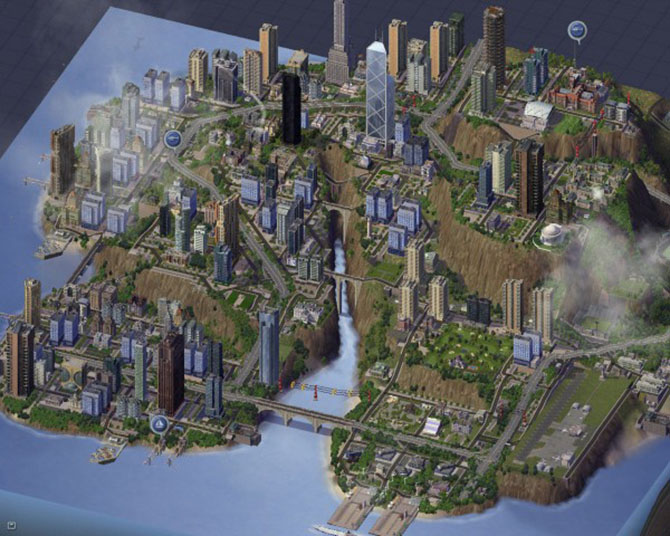
[Image: Screenshot from SimCity 4].

Manaugh: I’m curious how you dealt with previous versions of SimCity, and whether there was any anxiety about following that legacy or changing things. What are the major innovations or changes in this version of the game, and what kinds of things did you think were too iconic to get rid of?

Librande: First of all, when we started the project, and there were just a few people on the team, we all agreed that we didn’t want this game to be called SimCity 5. We just wanted to call it SimCity, because if we had a 5 on the box, everybody would think it had to be SimCity 4 with more stuff thrown in. That had the potential to be quite alienating, because SimCity 4 was already too complicated for a lot of people. That was the feedback we had gotten.

Once we made that title decision, it was very liberating—we felt like, “OK, now we can reimagine what the brand might be and how cities are built, almost from scratch.”

Technically, the big difference is the “GlassBox” engine that we have, in which all the agents promote a bottom-up simulation. All the previous SimCity games were literally built on spreadsheets where you would type a number into a grid cell, and then it propagated out into adjacent grid cells, and the whole city was a formula.

SimCity 4 was literally prototyped in Excel. There were no graphics—it was just a bunch of numbers—but you could type a code that represented a particular type of building and the formulae built into the spreadsheet would then decide how much power it had and how many people would work there. It just statically calculated the city as if it were a bunch of snapshots.

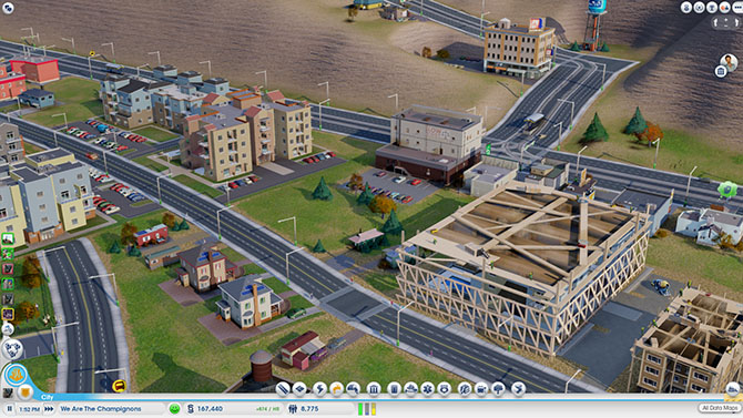
[Image: A fire breaks out in the city designed by We Are The Champignons].

Because our SimCity—the new SimCity—is really about getting these agents to move around, it’s much more about flows. Things have to be in motion. I can’t look at anybody’s city as a screenshot and tell you what’s going on; I have to see it live and moving before I can fully understand if your roads are OK, if your power is flowing, if your water is flowing, if your sewage is getting dumped out, if your garbage is getting picked up, and so on. All that stuff depends on trucks actually getting to the garbage cans, for example, and there’s no way to tell that through a snapshot.

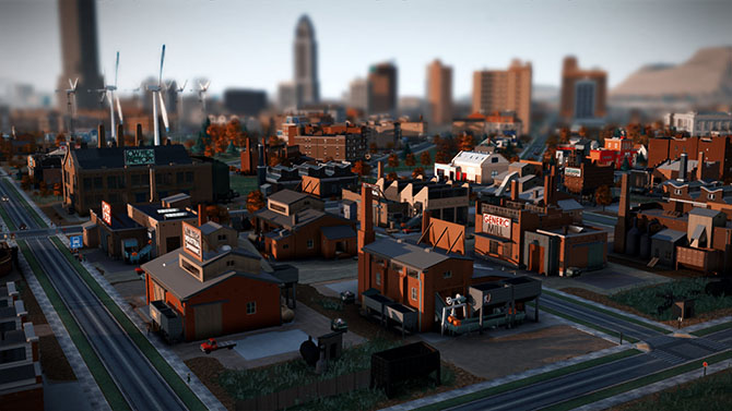
[Image: Sims queue for the bus at dawn].

Once we made that decision—to go with an agent-driven simulation and make it work from the bottom up—then all the design has to work around that. The largest part of the design work was to say: “Now that we know agents are going to run this, how do schools work with those agents? How do fire and police systems work with these agents? How do time systems work?” All the previous editions of SimCity never had to deal with that question—they could just make a little table of crimes per capita and run those equations.

Manaugh: When you turned things over to the agents, did that have any kind of spatial effect on game play that you weren’t expecting?

Librande: It had an effect, but it was one that we were expecting. Because everything has to be in motion, we had to have good calculations about how distance and time are tied together. We had to do a lot of measurements about how long it would really take for one guy to walk from one side of the city to the other, in real time, and then what that should be in game time—including how fast the cars needed to move in relationship to the people walking in order to make it look right, compared to how fast would they really be moving, both in game time and real time. We had all these issues where the cars would be moving at eighty miles an hour in real time, but they looked really slow in the game, or where the people were walking way, way too fast, but actually they were only walking at two miles an hour.

We knew this would happen, but we just had to tweak the real-life metrics so that the motion and flow look real in the game. We worked with the animators, and followed our intuition, and tried to mimic the motion and flow of crowds.

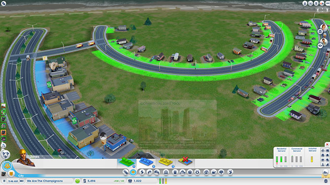
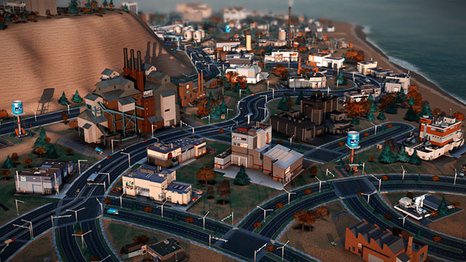
[Image: We Are The Champignons’ industrial zone, carefully positioned downwind of the residential areas].
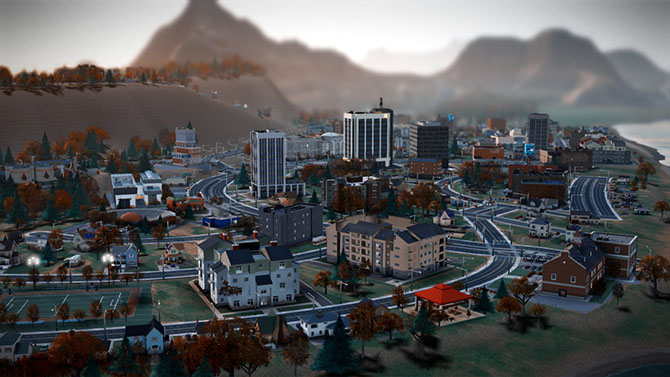
In the end, it’s not one hundred percent based on real-life metrics; it just has to look like real life, and that’s true throughout the game. For example, if we made the airport runways actual size, they would cover up the entire city. Those are the kinds of things where we just had to make a compromise and hope that it looked good.

Twilley: Actually, one of the questions we wanted to ask was about time in the game. I found it quite intriguing that there are different speeds that you can choose to play at, but then there’s also a distinct sense of the phases of building a city and how many days and nights have to pass for certain changes to occur. Did you do any research into how fast cities change and even how the pace of city life is different in different places?

Librande: We found an amazing article about walking speeds in different cities. That was something I found really interesting. In cities like New York, people walk faster, and in medium-sized or small towns, they walk a lot slower. At one point, we had Sims walking faster as the city gets bigger, but we didn’t take it that far in the final version.


I know what you are talking about, though: in the game, bigger cities feel a lot busier and faster moving. But there’s nothing really built into the game to do that; it’s just the cumulative effect of more moving parts, I guess. In kind of a counter-intuitive way, when you start getting big traffic jams, it feels like a bigger, busier city even though nothing is moving—it’s just to do with the way we imagine rush-hour gridlock as being a characteristic of a really big city.

The fact that there’s even a real rush hour shows how important timing is for an agent-based game. We spent a lot of time trying to make the game clock tick, to pull you forward into the experience. In previous SimCities, the day/night cycle was just a graphical effect—you could actually turn it off if you didn’t like it, and it had no effect on the simulation. In our game, there is a rush hour in the morning and one at night, there are school hours, and there are shopping hours. Factories are open twenty-four hours a day, but stores close down at night, so different agents are all working on different schedules.


The result is that you end up getting really interesting cycles—these flows of Sims build up at certain times and then the buses and streets are empty and then they build back up again. There’s something really hypnotic about that when you play the game. I find myself not doing anything but just watching in this mesmerized state—almost hypnotized—where I just want to watch people drive and move around in these flows. At that point, you’re not looking at any one person; you’re looking at the aggregate of them all. It’s like watching waves flow back and forth like on a beach.

For me, that’s one of the most compelling aspects of our game. The timing just pulls you forward. We hear this all the time—people will say, “I sat down to play, and three hours had passed, and I thought, wait, how did that happen?” Part of that is the flow that comes from focusing, but another part of it is the success of our game in pulling you into its time frame and away from the real-world time frame of your desk.


Twilley: Has anything about the way people play or respond to the game surprised you? Is there anything that you already want to change?

Librande: One thing that amazed me is that, even with the issues at the launch, we had the equivalent of nine hundred man-years put into SimCity in less than a week.

Most of the stuff that people are doing, we had hoped or predicted would happen. For example, I anticipated a lot of the story-telling and a lot of the creativity—people making movies in the cities, and so on—and we’re already seeing that. YouTube is already filled with how-to videos and people putting up all these filters, like film noir cities, and it’s just really beautiful.

[Video: SimCity player Calvin Chan’s film noir montage of his city at night].

The thing I didn’t predict was that, in the first week, two StarCraft players—that’s a very fast-paced space action game, in case you’re not familiar with it, and it’s fairly common for hardcore players to stream their StarCraft battles out to a big audience—decided to have a live-streamed SimCity battle against each other. They were in a race to be the first to a population of 100,000; they live-streamed their game; and there were twenty thousand people in the chat room, cheering them on and typing in advice—things like “No, don’t build there!” and “ What are you doing—why are you putting down street cars?” and “Come on, dude, turn your oil up!” It was like that, nonstop, for three hours. It was like a spectator sport, with twenty thousand people cheering their favorite on, and, basically, backseat city planning. That really took me by surprise.

I’m not sure where we are going to go with that, though, because we’re not really an eSport, but it seems like the game has the ability to pull that out of people. I started to try to analyze what’s going on there, and it seems that if you watch people play StarCraft and you don’t know a lot about it, your response is going to be something like, “I don’t know what I’m looking at; I don’t know if I should be cheering now; and I don’t know if what I just saw was exciting or not.”

But, if you watch someone build a city, you just know. I mean, I don’t have to teach you that putting a garbage dump next to people’s houses is going to piss them off or that you need to dump sewage somewhere. I think the reason that the audience got so into it is that everyone intuitively knows the rules of the game when it comes to cities.

• • •

For more Venue interviews, on human interactions with the built, natural, and virtual environments, check out the Venue website in full.

Sky Crane

[Image: View larger].

When I walked out to get breakfast this morning, clouds had obscured all but the topmost workings of the 1 World Trade Center site, visible through our living room window—a strange vision of machines, pulleys, cranes, and gears sort of hovering in the sky, like something out of Archigram by way of Hayao Miyazaki.

Documentary Holography

[Image: A “detail theft” by ScanLAB Projects].

ScanLAB Projects, a reliably interesting and enthusiastic design-research duo formed by Bartlett graduates Matthew Shaw and William Trossell, explores, in their words, “the potential of large scale terrestrial laser scanning as a tool for design, visualization and fabrication. We use a range of state-of-the-art 3D scanning technologies to capture buildings, objects and spaces.”

As it happens, they mean this quite literally, as they aim to “capture” and then illicitly reproduce, using multi-axis milling machines, architectural details scanned around London. These are what they call “detail thefts… arguably cloning the original architect’s intellectual property.”

[Image: A “detail theft” by ScanLAB Projects].

You can read an earlier write-up of their many projects—from “stealth objects” to scanner-jamming architectural ornament installed on an urban scale—here on BLDGBLOG (as well as in the forthcoming Landscape Futures book).

What I find so consistently interesting in their work, though, is that, over the past few years, they’ve been expanding the representational range of the laser scanner, using it to document highly ephemeral, even ethereal, spatial events.

Whether scanning mist and humidity or traveling north to the Arctic to shoot lasers at pressure ridges and melting ice floes, their work is almost a kind of documentary holography: not a film, not a photograph, not a 3D model, but also not simply a point-cloud, their work operates almost narratively as they capture objects or places in the process of becoming something else, blurred by passing fog or pulled apart by unseen ocean currents. You could write a screenplay for scanners.

[Images: From the “Arctic Climatic Tour 2011” of ScanLAB Projects].

For a more recent project, one that indicates a growing environmental or ecological emphasis in their work, the duo found themselves in the presence of heavy forestry equipment, a haunting and behemoth machine busy uprooting, de-branching, and stacking trees, converting a living forest to mere timber. The satiny black background makes it all that much more dreamlike, as if occurring in secret at 2am.

[Image: Forestry Commission Tree Harvester by ScanLAB Projects; view larger].

Cast in black and white and seeming to gleam in the laser light, the machine is both dinosaur-like and ghostly, implying the total gutting of the forest around it as the orderly bar code of the trees is disrupted by this artificial clearing.

[Image: Scans of a Forestry Commission tree harvester in action, by ScanLAB Projects; view image one, two, three, and four larger!].

In all cases, the images are much more evocative when viewed at a larger size (see captions for direct links), which you can also find on the ScanLAB Projects website.

Finally, if all this interests you, consider signing up for a 10-day workshop with ScanLAB Projects up in Ottawa, Canada, from 5-13 July 2013, focusing on “post-industrial landscapes.” Here’s the course description:

Set within the context of a post-industrial era, we find ourselves venturing through the Canadian wilderness of Gatineau Park, walking in the footsteps of industrial alchemist Thomas “Carbide” Willson. Within this natural blossom lie the ruins of his former empire, the decaying heart of industrialization and manufacturing in a factory that never fully materialized.
The course will explore 3D devices that can scan the unnatural post-industrial landscape in an attempt to fuse the accidental qualities of discovery—such as Willson’s trial and error of calcium carbide—with the mathematical precision of laser-scanned environments. Students will form their own architectural “carbide,” a fusion of scans and digital modeling to generate a landscape that materialies from Willson’s place of decay into a new architectural ground.

More information, including registration, is available here.

On the Rise

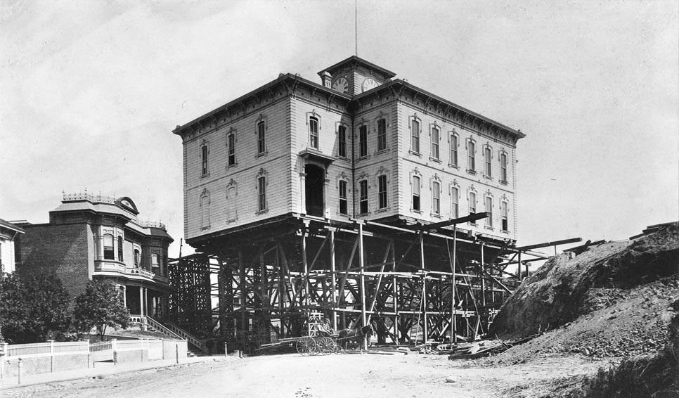
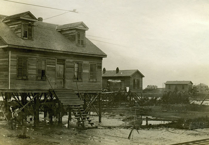
[Image: A Galveston house on stilts, courtesy of the Galveston County Museum, Galveston, Texas, via Science Friday].

Following the catastrophic hurricane of 1900, the city of Galveston, Texas, was vertically raised up to 17 feet from its original ground level using “hand-cranked janks and mules,” NPR’s Science Friday explained last week.

In order to “protect itself from future storms,” Dwayne Jones of the Galveston Historical Foundation told the radio program, the city set about constructing a defensive seawall. “And the city began to be raised behind it,” he adds, “so everything was lifted up… Houses, out-houses, sidewalks, fences—everything was raised.”

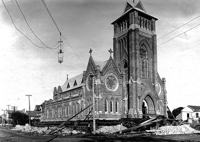
[Image: “One hundred men worked to raise the church, one-half inch at a time, for 35 days. Once the correct height was reached, a new concrete foundation was poured.” Image courtesy of the Galveston County Museum, Galveston, Texas, via Science Friday].

The whole town, in effect, was “lifted up and put on blocks,” including huge masonry structures, such as Galveston’s St. Patrick Catholic Church. The church was held off the earth by nearly 700 separately hand-operated jacks. The church was kept level as it was raised only one half-inch a day for 35 days, lifted off the ground as if you were changing its tires.

The description brings to mind the truly extraordinary photographs of North Moore High School being moved across Los Angeles, posted here back in 2011.

[Images: Moving Fort Moore High School in Los Angeles, 1886; photos courtesy of the Title Insurance and Trust/C.C. Pierce Photography Collection, USC Libraries].

Commenting on the seven-year time span of the overall town-lifting operation, Jones describes how the soil there in Galveston is “all sand.” These soft ground conditions meant that the engineers could “put canals through, and they had barges and pumps that took the soil or the fill from Galveston Bay and pumped it underneath the properties. So they would go kind of block by block, lift the properties up in that block, pump underneath it, and keep going across the island.” The city dredged itself.

In any case, the short but interesting radio segment goes on to discuss contemporary structure-moving operations in New Orleans, Chicago, and beyond, with the ultimate implication that perhaps the inhabited coastal periphery of the greater New York City area might also someday see itself on the rise.

(Thanks to Ed Porter for the tip!)

Shapes from the Dream Mine

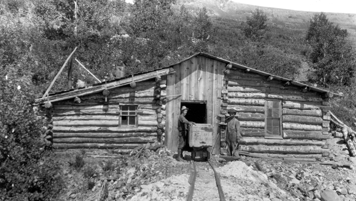
[Image: Tunnel House, Dream Mine, Johnson Creek, Abajo Mountains, San Juan County, Utah (1915); courtesy of the USGS].

I don’t have much to say about this image, other than it depicts the architectural workings of something called the Dream Mine, located in the Abajo Mountains of Utah and photographed back in 1915.

But it’s such a great name—the Dream Mine—perhaps suggesting that, somewhere out there in the American desert, there is a reserve surplus or underground stockpile of unconscious aspiration stored inside the earth, a kind of geological harddrive where the dreams of the whole nation have been frozen like holographs in mineral glass.

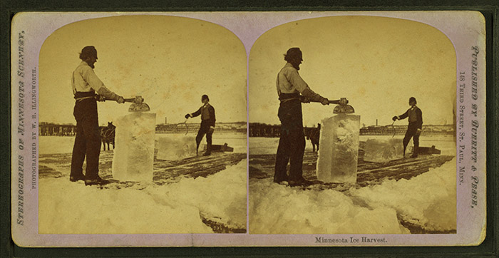
[Image: An otherwise unrelated photo of an ice-harvesting operation in Minnesota—but perhaps this is what it would look like to mine dreams. Courtesy of Wikipedia].

Using red and blue lasers, subterranean excavators trained in neurology cut slow sequences from flowstone and ship televisual crystals out along the interstate, rare dreams distributed direct from this underground site in Utah. We’ll simply mine our dreams from the earth and ship them out in perfect, white cubes from the dark roots of distant mountains to the rest of the world. It’s logistics.

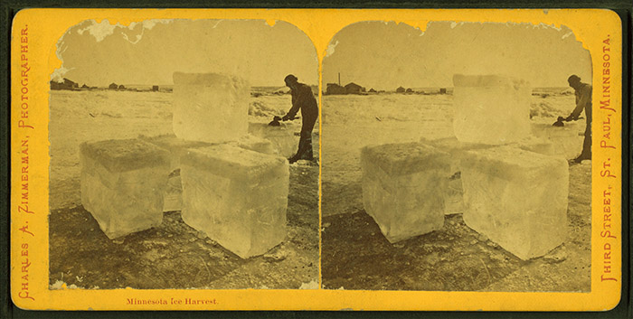
[Images: More ice-harvesting from Minnesota].
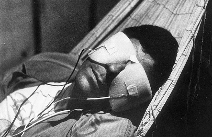
Alas, the actual Dream Mine worked the other way around: that is, it was inspired by a dream experienced by John H. Koyle, a Mormon pioneer.

In August 1894 [Koyle] experienced a dream in which he was visited by a figure from another world. The visitor carried him to a high mountain east of Koyle’s house and into the mountain, showing him the various strata and explaining the meaning of the minerals. The visitor showed Koyle an ancient “Nephite” mine with large rooms of mined-out ore bodies. The rooms contained treasure and artifacts of an extinct civilization. Koyle was instructed that he was to open a mine and extract gold for the welfare of “his” people. Specific instructions were given for the mine development leading to rich ore bodies.

“Koyle’s dreams continued,” the University of Utah explains. “He especially received instruction on how to develop the mine. Plans included air shafts, escape ways and drainage tunnels. Instructions came to build a processing mill and storage bins for grain.” In other words, Koyle claimed to have received technical plans for the mine in his sleep, down to the precise construction of ventilation shafts.

It would be interesting, in this context, to learn that the entire New York City subway system had been built according to plans seen in a dream by some tweed-bound engineer of the 19th-century—rolling in his sleep at night with visions of stairs coiling into the earth and tunnels connected cellar to cellar across the island like a circuit board—and whether knowing that would affect how millions of commuters look at their daily train trips, as if passing through a 3D model of the mind of a stranger.

[Images: From La Jetée, directed by Chris Marker].

Of course, it was all for naught: the gold was never discovered. However, some apparently still hold out for a Tea Party-like moment of mineralogical revealing on some future day in which the global economy has collapsed and the only thing left with value is gold… all the many, many thousand tons of it stored somewhere in the mountains of Utah and dreamt of decades ago by John Koyle, an incalculable stash as yet unreachable by today’s technologies.

Salt Lake City’s City Weekly jokes (under the headline “prophet sharing”) about “the mine’s ancient and fabled promise: wealth beyond imagination, where rivers of precious gold and platinum course beneath the docile farm community. What’s more, nine vaults are said to lie deep within the mine, filled with the treasures left by an ancient race from the Book of Mormon known as the Nephites. As legend goes, the Nephites’ wealth was set aside for God’s chosen people during a time of uncertainty as a blessing to fortify the faithful against the ensuing chaos of the apocalypse.”