[Image: The Heathen Gate at Carnuntum, outside Vienna; photo by Geoff Manaugh.]
Last summer, a geophysicist at the University of Vienna named Immo Trinks proposed the creation of an EU-funded “International Subsurface Exploration Agency.” Modeled after NASA or the ESA, this new institute would spend its time, in his words, “looking downward instead of up.”
The group’s main goal would be archaeological: to map, and thus help preserve, sites of human settlement before they are lost to development, natural decay, climate change, and war.
Archaeologist Stefano Campana, at the University of Siena, has launched a comparable project called Sotto Siena, or “Under Siena”—abbreviated as SOS—intended to survey all accessible land in the city of Siena.
[Image: A few of Siena’s innumerable arches; photo by Geoff Manaugh.]
That project’s goal is primarily to catalog the region’s millennia of human habitation and cultural artifacts, but, like Immo Trinks and his proposed ISEA, is also serving to document modern-day infrastructure, such as pipes, utilities, sewers, and more. (When I met Campana in Siena last year, I was interested to learn that a man who had walked over to say hello, who was introduced to me as an enthusiastic supporter of Campana’s work, was actually Siena’s chief of police—it’s not just archaeologists who want to know what’s going on beneath the streets.)
I had the pleasure of tagging along with both Trinks and Campana last year as part of my Graham Foundation grant, “Invisible Cities,” and a brief write-up of that experience is now online over at WIRED.
The article begins in Siena, where I joined Campana and two technicians from the Livorno-based firm GeoStudi Astier for a multi-hour scan of parks, piazzas, and streets, using a ground-penetrating radar rig attached to a 4WD utility vehicle.
[Images: The GPR rig we rode in that day, owned and operated by GeoStudi Astier; photos by Geoff Manaugh.]
We stayed out well past midnight, at one point scanning a piazza in front of the world’s oldest bank, an experience that brought back positive memories from my days reporting A Burglar’s Guide to the City (alas, we didn’t discover a secret route into or out of the vault, but just some fountain drains).
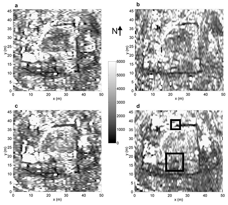
In Vienna, meanwhile, Trinks drove me out to see an abandoned Roman frontier-city and military base called Carnuntum, near the banks of the Danube, where he walked me through apparently empty fields and meadows while narrating all the buildings and streets we were allegedly passing through—an invisible architecture mapped to extraordinary detail by a combination of ground-penetrating radar and magnetometry.
“We want to map it all—that’s the message,” Trinks explained to me. “You’re not just mapping a Roman villa. You’re not mapping an individual building. You are mapping an entire city. You are mapping an entire landscape—and beyond.”
An estimated 99% of Carnuntum remains unexcavated, which means that our knowledge of its urban layout is almost entirely mediated by electromagnetic technology. This, of course, presents all sorts of questions—about data, machine error, interpretation, and more—that were explained to me on a third leg of that trip, when I traveled to Croatia to meet Lawrence B. Conyers.
[Image: A gorge leading away behind the archaeological site I visited on the island of Brač, Croatia; photo by Geoff Manaugh.]
Conyers is an American ground-penetrating radar expert who, when we met, was spending a couple of weeks out on the island of Brač, near the city of Split. He had traveled there to scan a hilltop site, looking for the radar signatures of architectural remains, in support of a project sponsored by the University of Colorado at Boulder.
Conyers supplies a voice of caution in the WIRED piece, advising against over-relying on expensive machines for large-scale data collection if the people hoarding that data don’t necessarily know how to filter or interpret it.
[Image: Lawrence Conyers supervises two grad students using his ground-penetrating radar gear; photo by Geoff Manaugh.]
The goal of an International Subsurface Exploration Agency could rise or fall, in other words, not just on questions of funding or public support, but on the limits of software analysis and human interpretation: are we sure that what we see on the screens of our machines is actually there, underground?
When we spoke in Siena, Campana used the metaphor of a medical biopsy, insisting that archaeologists and geophysicists will always need to excavate, not just for the recovery of historical artifacts and materials, but for verifying their own hypotheses, literally testing the ground for things they think they’ve seen there.
Archaeologist Eileen Ernenwein, co-editor of the journal Archaeological Prospection, also emphasized this to me when I interviewed her for WIRED, adding a personal anecdote that has stuck with me. During her graduate thesis research, Ernenwein explained, she found magnetic evidence of severely eroded house walls at an indigenous site in New Mexico, but, after excavating to study them, realized that the structure was only visible in the electromagnetic data. It was no less physically real for only being visible magnetically—yet excavation alone would have almost certainly have missed the site altogether. She called it “the invisible house.”
In any case, many things have drawn me to this material, but the long-term electromagnetic traces of our built environment get very little discussion in architectural circles, and I would love this sort of legacy to be more prominently considered. What’s more, our cultural obsession with ruins will likely soon begin to absorb new sorts of images—such as radar blurs and magnetic signatures of invisible buildings—signaling an art historical shift in our representation of the architectural past.
For now, check out the WIRED article, if you get a chance.
(Thanks again to the Graham Foundation for Advanced Studies in the Fine Arts for supporting this research. Related: Through This Building Shines The Cosmos.)
[Image: From Kiessling’s Grosser Verkehrs-Plan von Berlin (1920).]
It’s funny to be back in Berlin, a city where I once thought I’d spend the rest of my life, first arriving here as a backpacker in 1998 and temporarily moving in with a woman 14 years older than me, who practiced Kabbalah and had twin dogs and who, when seeing that I had bought myself a portable typewriter because I was going through a William Burroughs phase, blessed it one night in her apartment near the synagogue in a ceremony with some sort of bronze sword. It’s almost literally unbelievable how long ago that was. More years have passed since I spent time in Berlin—supposedly to study German for grad school, but in reality organized entirely around going to Tresor—than I had been alive at the time.
Because I’m here again on a reporting trip, I was speaking yesterday evening with a former geophysicist who, when the Berlin Wall came down, found work doing site-remediation studies and heritage-mapping projects on land beneath the old path of the Wall. He was tasked with looking for environmental damage and unexploded ordnance, but also for older foundations and lost buildings, earlier versions of Berlin that might pose a structural threat to the city’s future or that needed to be recorded for cultural posterity.
Ironically, in a phase of my life I rarely think about, I wrote my graduate thesis on almost exactly this topic, focused specifically on Potsdamer Platz—once divided by the Wall—and the role of architectural drawings in communicating historical context. When I was first here, in 1998 into early 1999, Potsdamer Platz was still a titanic hole in the ground, an abyss flooded with groundwater, melted snow, and rain, a kind of maelström you could walk over on pedestrian bridges, where engineering firms were busy stabilizing the earth for what would become today’s corporate office parks.
As I told the former geophysicist last night, I remember hearing at the time that there were people down there, SCUBA diving in the floodwaters, performing geotechnical studies or welding rebar or looking for WWII bombs, I had no idea, but, whatever it was, their very existence took on an outsized imaginative role in my experience of the city. Berlin, destroyed by war, divided by architecture, where people SCUBA dive through an artificial sea at its broken center. It felt like a mandala, a cosmic diagram, with this inverted Mt. Meru at its heart, not an infinite mountain but a bottomless pit.
What was so interesting to me about Berlin at the time was that it felt like a triple-exposure photograph, the city’s future overlaid atop everything else in a Piranesian haze of unbuilt architecture, whole neighborhoods yet to be constructed, everything still possible, out of focus somehow. It was incoherent in an exhilaratingly literal sense. In Potsdamer Platz, what you thought was the surface of the Earth was actually a bridge; you were not standing on the Earth at all, or at least not on earth. It was the Anthropocene in miniature, a kind of masquerade, architecture pretending to be geology.
The more that was built, however, the more Berlin seemed to lose this inchoate appeal. The only people with the power to control the rebuilding process seemed to be automobile consortiums and international hotel groups, office-strategy consultants not wizards and ghosts or backpacking writers. Perhaps the city still feels like that to other people now—unfinished, splintered, jagged in a temporal sense, excitingly so, a city with its future still taking shape in the waves of an underground sea—but it seems to me that Berlin’s blur has been misfocused.
In any case, with the caveat that I am in Berlin this week for a very specific research project, so many people I’ve met have pointed to the fall of the Wall as an explosive moment for geophysical surveys in the East. Engineers were hired by the dozen to map, scan, and survey damaged ground left behind by a collapsed imperialist Empire, and the residues of history, its chemical spills and lost foundations, its military bunkers and archaeological remains, needed to be recorded. The ground itself was a subject of study, an historical medium. On top of that, new freeways were being built and expanded, heading east into Poland—and this, too, required geophysical surveys. The future of the region was, briefly, accessible only after looking down. The gateway to the future was terrestrial, a question of gravel and sand, forgotten basements and fallen walls.
The SCUBA divers of the Potsdamer Sea now feel like mascots of that time, dream figures submerged in the waves of a future their work enabled, swimming through historical murk with limited visibility and, air tanks draining, limited time. Their pit was soon filled, the hole annihilated, and the surface of the Earth—which was actually architecture—returned with amnesia.
[Image: “Constant time slices” reveal buildings buried in northwestern Argentina; image from, and courtesy of, the Journal of Archaeological Science, “Detecting and mapping buried buildings with Ground-Penetrating Radar at an ancient village in northwestern Argentina,” by Néstor Bonomo, Ana Osella, and Norma Ratto].
While reading The Losers last night for the first time—a graphic novel about a team of ex-CIA members now executing a series of elaborate heists against their former employer—I was pleasantly surprised to see that one of the final scenarios involves a small volcanic island featuring an abandoned village that had very recently been buried by ash and pumice.
In a nutshell, the buildings beneath all that rock and ash are still intact—and one of them contains a locked safe that our eponymous group of “losers” is searching for. So begins an unfortunately quite short scene of vertical archaeology: locating the proper building amidst the featureless landscape of ash, blasting a hole down through the building’s roof, stabilizing the ceiling from within so that heavy-lifting equipment can be installed on the rooftop, and then descending into the hallways and staircases below by way of mountaineering ropes to find the safe.
For whatever reason, there are few things I find more exciting to read about than high-risk descents into buried cities, especially one that, as in the case of The Losers, remains otherwise indistinguishable from the surface of the earth, only gradually revealing itself to be an extraordinary honeycomb of connected rooms and passages—and this brief moment in the book was made even more interesting when I remembered a handful of articles I’d saved last year, one of which also involves a lost village, buried by volcanic ash.
[Image: A selection of “time slices” from the buried buildings of northwestern Argentina; image from, and courtesy of, the Journal of Archaeological Science, “Detecting and mapping buried buildings with Ground-Penetrating Radar at an ancient village in northwestern Argentina,” by Néstor Bonomo, Ana Osella, and Norma Ratto].
In a 1998 paper from the Journal of Applied Geophysics, called “The use of ground penetrating radar to map an ancient village buried by volcanic eruptions,” we read about a village in Japan called Komochi-mura, in Gunma prefecture: “The entire area surrounding the village is covered by a thick deposit of pumice derived from the eruption of Futatsudake volcano of Mt. Haruna, approximately 10km to the southwest of the village.”
Beneath the modern village, its predecessor from the middle of the 6th century is buried by the pumice deposits. Since these were laid down over a very short period, the ancient village should survive in a high state of preservation and will therefore contain much significant archaeological information. Ground penetrating radar (GPR) has been used to investigate this site over a period of 10 years. As a result, the plan of the ancient village can be accurately mapped… In this paper, the authors demonstrate how GPR was able to map the structural remains of the ancient village under a deposit of pumice.
In addition to various buildings, “pit-dwellings,” and other destroyed structures preserved but invisibly buried beneath today’s village, “traces of brushwood hedges, paths and other slight features have also been identified by the survey.”
These types of articles—on the remote-sensing of buried architectural remains, using technologies that “can detect and map buried structures without disturbing them,” in the words of the paper I am about to cite—are increasingly easy to find, but no less interesting because of their ubiquity.
Another paper, then, called “Detecting and mapping buried buildings with Ground-Penetrating Radar at an ancient village in northwestern Argentina,” published in 2010 in the Journal of Archaeological Science, describes an archaeological survey in which ground-penetrating radar was used “in order to detect new buildings,” including a system of “complex wall distribution and a number of unknown enclosures.” These “new buildings,” however, were just signals from the earth awaiting spatial interpretation:
The exploration showed signals of mud-walls in a sector that was located relatively far from the previously known buildings. A detailed survey was performed in this sector, and the results showed that the walls belonged to a large dwelling with several rooms. The discovery of this dwelling has considerably extended the size of the site, showing that the dwellings occupied at least twice the originally assumed area. High-density GPR surveys were acquired at different parts of the discovered building in order to resolve complex structures. Interpreted maps of the building were obtained.
“From the joint analysis of the transverse sections, time slices and volume slices of the data and their time averaged intensity,” the authors explain, “we have obtained a final map for the new building”—where the “new” building, of course, is a much older, forgotten one, a structure interpretively remade and refreshed through this newfound legibility.
[Image: From “Archaeological microgravimetric prospection inside don church (Valencia, Spain),” by Jorge Padín, Angel Martín, Ana Belén Anquela, in a 2012 issue of the Journal of Archaeological Science].
Architecture, in this context, comes to our attention first as a series of “intensity blots continued through consecutive slices,” an almost impossibly abstract geometry of signals and reflections, of patterned “electromagnetic responses” hidden in the landscape.
In all of these cases, it’d be interesting to propose a kind of archaeological discovery park the size of a football stadium, whose interior is simply a massive, open-span paved landscape on which small devices like floor-waxing machines or lawnmowers have been parked. Paying visitors can walk out onto this vast, continuous monument of bare concrete where they will begin moving the machines around, cautiously at first but then much more ambitiously, revealing as they do so the underground perimeters and outlines of entire villages buried deep in the mud and gravel beneath the building. The “park” is thus really a kind of terrestrial TV show of invisible architecture previously lost to history but beautifully preserved—that is, entombed—in the geology below.
In any case, in writing this post I’ve realized that I’ve accumulated over the past two years or so several gigabytes’ worth of PDFs about these and other archaeological technologies—from mapping ancient ships buried in the Egyptian pyramids and micro-gravity detection of “shallow subsurface structures” in a church in Italy (“indicating,” in the authors’ words, “that the actual church was constructed above another one”) to “archaeomagnetic data” taken from Roman sites in Tunisia—but here’s at least one more reference for good measure.
In a paper called “Ground penetrating radar (G.P.R.) surveys applied to the research of crypts in San Sebastiano’s church in Catania (Sicily),” from a 2007 issue of the Journal of Cultural Heritage, a team of Italian geophysicists explored “natural or anthropic buried cavities” under a church in Sicily—that is, both architectural chambers and caves physically inaccessible in the foundations of the building. Soon enough, the authors write, “the existence of hidden structures was revealed.”
“In fact,” they add, “a crypt with a barrel vault, under the central aisle of the church, and a room of small dimensions next to this crypt were identified. Moreover, near the altar, the presence of a quadrangular crypt with a cross-vault was revealed. The presence of such buried masonries confirms that the church, rebuilt on previous building rests, has been subjected along the centuries to repeated repairs.”
[Image: The church of San Sebastiano in Catania, Sicily, courtesy of the regional tourism council].
There is something particularly awesome—that is, it is a story that lends itself particularly to metaphor—about envisioning a squad of well-equipped scientists setting up shop in a church in Sicily, using radar and rigs of strange antennae to scan the structure around them for secret rooms, heavenly nooks and crannies out of human reach. A kind of electromagnetic baroque.
The paper cited in a caption above—”Archaeological microgravimetric prospection inside don church (Valencia, Spain),” by Jorge Padín, Angel Martín, Ana Belén Anquela, from a 2012 issue of the Journal of Archaeological Science—even includes such strangely resonant lines as calculating against “residual gravity anomalies” in a “microgravimetric correction for the altar,” as if the high science of geophysical investigation has been rhetorically wed with theological speculation.
In the words of a paper by N. Farnoosh et al., published in a 2008 issue of NDT & E International, analyzing a given architectural space becomes a question of “buried target detection” using high-tech means—that is, establishing a sustained and coordinated “electromagnetic interaction among the radar antennas, ground, and buried objects.”
Here, the study of architectural history can very, very loosely be compared to astronomy: using tools of remote-sensing, including antennae, but targeted downward, into the earth, to reveal the flickering, gossamer traces of something that, for a variety of reasons, humans can’t yet physically reach. Like astronomy, then, archaeology and architectural history become a case of interpreting signals from afar, not of stars and supernovae but of lost rooms and buildings beneath our feet.
[Images: (left) An archaeologist examines soil cores. (right) Researchers plot lost roads across the grounds of Monticello. Courtesy of the Glenn A. Black Laboratory of Archaeology at IU Bloomington].
It’s hard to resist a caption referring to a “team of researchers” who have used their “electrical resistivity profiler to discover long-buried roads around the historic Virginia home” of 18th century U.S. president Thomas Jefferson. But that’s exactly what you’ll see courtesy of a recent press release from Indiana University.
Specifically, we read, a team of Indiana University archaeologists have “conducted a landscape study to find evidence of two lost roads: a ‘kitchen road’ that serviced the Monticello kitchen, and a formal carriageway that circled along the Ellipse Fence marking the edge of the East Lawn and the formal landscape in front of Monticello.”
A combination of soil cores and direct electrical data helped that team outline this otherwise lost geography at the heart of U.S. presidential history and across the original lawns of American Palladianism. Jefferson, as you might know, was an architect, one heavily influenced by the texts and buildings of Andrea Palladio. American architecture, from day one, was, in a sense, a facsimile: created, with far-reaching variations and personal stylistic quirks, based on reproduced manuscripts from Europe.
In any case, stepping back: beneath Jefferson’s lawn are lost roads.
I’m reminded here of an amazing story published two years ago in the New York Times about “ancient roads,” dating from colonial times, in the U.S. state of Vermont.
As the The New York Times explained back then, a 2006 state law gave Vermont residents a strong incentive to uncover the buried throughways in, around, and through their often quite rural towns. Indeed, “citizen volunteers are poring over record books with a common, increasingly urgent purpose: finding evidence of every road ever legally created in their towns, including many that are now impassable and all but unobservable.”
These “elusive roads”—many of them “now all but unrecognizable as byways”—are lost routes, connecting equally erased destinations. In almost all particular cases, they have barely even left a trace on the ground; their presence is almost entirely textual.
They are not just lost roads; they are road that have been deterrestrialized.
If these ancient routes can be re-discovered, however, then Vermont state law dictates that they can also be added to official town lands (and thus be eligible for some kind of federal something-or-other). Accordingly:
Some towns, content to abandon the overgrown roads that crisscross their valleys and hills, are forgoing the project. But many more have recruited teams to comb through old documents, make lists of whatever roads they find evidence of, plot them on maps and set out to locate them.
And, in what is surely one of the most interesting geographical subplots in recent newspaper publishing, we read: “Even for history buffs, the challenge is steep: evidence of ancient roads may be scattered through antique record books, incomplete or hard to make sense of.”
Like something out of the poetry of PaulMetcalf, or even William Carlos Williams, the descriptions found in these old documents are narrative, impressionistic, and vague. They “might be, ‘Starting at Abel Turner’s front door and going to so-and-so’s sawmill,’ said Aaron Worthley, a member of the ancient roads committee in Huntington, southeast of Burlington. ‘But the house might have burned down 100 years ago. And even if not, is the front door still where it was in 1815? These are the kinds of questions we’re dealing with.'”
While making sense of cryptic references to lost byways is fascinating in and of itself, these acts of perambulatory interpretation are part of a much larger, fairly mundane attempt to end “fights between towns and landowners whose property abuts or even intersects ancient roads.”
In the most infamous legal battle, the town of Chittenden blocked a couple from adding on to their house, saying the addition would encroach on an ancient road laid out in 1793. Town officials forced a showdown when they arrived on the property with chain saws one day in 2004, intending to cut down trees and bushes on the road until the police intervened.
The article here goes on to refer to one local, a lawyer, who explains that “he loved getting out and looking for hints of ancient roads: parallel stone walls or rows of old-growth trees about 50 feet apart. Old culverts are clues, too, as are cellar holes that suggest people lived there; if so, a road probably passed nearby.”
What would happen, then, if you discovered that an ancient road actually passes through your house? Your living room is a former throughway, and old paths knot and twirl off to every side; one even leads right through the guest bedroom. And then another road pops up, and another—and you realize that you live on the intersecting scars of a lost built environment, some old village that disappeared or was destroyed in an H.P. Lovecraft-like enigmatic disaster.
[Image: An old Roman road in Britain; photo via Historic UK].
I’d also be curious, meanwhile, to see what might happen if such a law was passed in a city like London. In an old but interesting review of the book London: City of Disappearances, edited by Iain Sinclair, we’re told that London “is a city of the forgotten.” It is where anyone “can still disappear without trace.” Indeed, London is a city “built upon lost things”; it “towers above forgotten underground rivers and discarded tunnels. It is built upon old graveyards and burial pits.”
Best of all, entire London streets have disappeared: “Catherine Street, Jewin Street, Golden Place are just three of the vanished thoroughfares named in a litany of sorrowful mysteries,” our reviewer points out. “Other streets have been curtailed. Swallow Street has been swallowed by burgeoning London. Grub Street has been renamed Milton Street.”
So what would happen if someone—who liked “getting out and looking for hints of ancient roads”—were to set about such a task elsewhere, in a city made from unstable geographies flashing in and out of county land registers?
I’m reminded here of China Miéville’s short story “Reports of Certain Events in London,” in which “unstable” streets appear and disappear throughout the city. One night they’re there, the next night they’re not.
Or take Chris Carlsson’s explorations of San Francisco’s ghost streets. “Intrepid explorers of San Francisco regularly stumble upon the many ghost streets that still hide all over town, rewarding the patient pedestrian for their diligence,” Carlsson wrote last autumn. “Mostly they are on hillsides where steep grades impeded road building at earlier moments in history, but they’re still presented as if they were through-streets on the maps.”
[Image: A map of San Francisco, including many “ghost streets,” courtesy of Streetsblog SF].
Carlsson’s post—something every San Franciscan should read—seemingly paved the way for a later exploration of “San Francisco’s unaccepted streets,” throughways too ephemeral for any real act of archaeology.
This unaccepted geographical unconscious of the city was recently mapped by Nicholas de Monchaux in an awesomely ambitious project called Local Code. It’s hard to exaggerate how interesting this project is; the following embedded video barely does it justice:
Here we are, then, surrounded by lost roads, forgotten throughways, and unaccepted streets. We turn on ground-penetrating radar and we find lost highways. What new cartographies could possibly account for these layers? With avenues leading nowhere and medieval freeways whose stratigraphic routes remain unpaved?
Finally—though by no means answering these questions—roughly two years ago, historian Kitty Hauser published a book called Bloody Old Britain. That book told the story of pilot, and accidental archaeologist, O.G.S. Crawford. Crawford pioneered the use of aerial photography in both discovering and analyzing ancient sites. Learning to read the landscape from the air, on the look-out for German ditches and bunkers, Crawford “would later apply this kind of skill honed in war, the trained interpretation of visual evidence, to the peacetime work of archaeology,” Hauser writes.
In the process, he realized almost instantly that you could detect, from high above, the traces of ancient landscape features that would otherwise have gone unseen. For instance, “at certain times of day, when the sun is low in the sky, the outlines of ancient fields become visible over Salisbury Plain, as shadows throw their ridges and dimples into sharp relief; these are known as ‘shadow sites.’” Much of this comes down to the specific species of plant growing over these landscapes:
Field archaeologists know that vegetation grows differently on soil that has been disturbed, even if that disturbance happened centuries ago. They know that crops grow more luxuriantly over silted-up ditches, and more stunted where there are buried remains. The site of a Roman villa might go unnoticed until a field of wheat grows and ripens, to reveal most strangely the outlines of buried masonry, only to disappear again at harvest. Slight contours or indentations on the land marking out the site of a lost settlement might be invisible to the eye until a low sun throws them into sharp but momentary relief.
Further:
Barley is a more sensitive ‘developer,’ for example, than oats, wheat, or grass, but only in certain soils. Dry spells can bring about remarkably sharp crop sites, like the outline of the medieval tithe barn, complete with buttresses, that appeared in the grass at Dorchester in June of 1938.
Hauser continues, pushing the awe factor:
One of the most remarkable things about aerial archaeology is that very few human processes will completely remove a site from view for ever. It might be decades—centuries even—before the right combination of crop growth, rain, sun, and aerial observer results in a site manifesting itself and being photographed. But unless deep excavations or quarrying are carried out, removing all traces of the site, the possibility remains that one day, under new conditions, it will reveal itself.
And, thus, “Photographs of unimpressive-looking mounds and lumps, the sort of thing one might not notice as one went past in a car or a train, turn out to be burial mounds, still for all we know containing crouching skeletons or buried treasure. You just needed to know where to look.” And Crawford knew where to look: there were ancient archaeological features everywhere, from buried roads to wooden menhirs rotting back into the soil. Britain was very old, Crawford himself could see; it was Bloody Old Britain.
[Image: O.G.S. Crawford and his archaeological airplane; via Kitty Hauser’s Bloody Old Britain].
What, then, if we could combine all this? Dead streets buried beneath the sprawling lawn of a U.S. president—himself now erased from the historical memory of U.S. Conservatives—crossed with lost streets from San Francisco, wed with linear archaeological sites known only from the air of 1910s England, meeting ancient roads through the hills of rural Vermont, informing short story sci-fi by China Miéville: how does our understanding of the built environment accordingly change?
What ancient routes exist all around us—like the dead streets of California City?
When I first mentioned the story of Vermont’s ancient roads two years ago on BLDGBLOG, commenters pointed out things like the Icknield Way, a.k.a. the “oldest road in Britain,” as well as lost railway lines in North Dakota:
I’ve done a lot of ‘landscape hermeneutics’ with former rail lines. I’m working on photographing every town in North Dakota, and most of these towns were built on a rail line. Many of those lines are now long-gone, so there’s often a ridge running through the town where the railroad used to be. Some of the tiniest spots (like Petrel) that still manage to get on the map can only be identified by a swath of cleared land where a railroad siding and depot might have been.
Or, from Ian Milliss, perhaps the best commenter in BLDGBLOG history (punctuation added):
For the last two years I’ve been on a National Trust committee working on heritage listing for Coxs Road, the first road across the Blue Mountains west of Sydney that opened up Australia to European settlement. Its bicentenary is in 2015.
Numerous pieces of it survive intact, and it does, indeed, sometimes disappear under houses. I’ve also been working on an overlay of it for Google Earth and even some virtual sections done using SketchUp… Its entire construction is detailed in the diaries and reports of its builders so that it can still be tracked through farmland where there is no visible trace of it.
It also relates to Australian indigenous mapping via ancestor stories and songlines, to produce virtual highways that can easily be followed but have very little obvious physical evidence of their existence.
Geography is a dream. Like an absorbed twin, we are surrounded by forgotten roads. That there are lost routes even at the spatial core of the U.S. presidency is just one of many surprising acts of poetry that this world seems always capable of.
(Monticello story spotted via Jessica Saraceni’s great newsfeed over at Archaeology Magazine. Of interest, meanwhile, earlier on BLDGBLOG: Ancient Roads, from which part of this post actually comes, Ancient Lights, and Z).
 [Image: The Heathen Gate at Carnuntum, outside Vienna; photo by Geoff Manaugh.]
 [Image: A few of Siena’s innumerable arches; photo by Geoff Manaugh.]

 [Images: The GPR rig we rode in that day, owned and operated by GeoStudi Astier; photos by Geoff Manaugh.]
 [Image: A gorge leading away behind the archaeological site I visited on the island of Brač, Croatia; photo by Geoff Manaugh.]
 [Image: Lawrence Conyers supervises two grad students using his ground-penetrating radar gear; photo by Geoff Manaugh.]
 [Image: From Kiessling’s Grosser Verkehrs-Plan von Berlin (1920).]
 [Image: “Constant time slices” reveal buildings buried in northwestern Argentina; image from, and courtesy of, the
 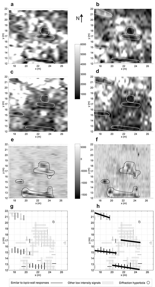 [Image: A selection of “time slices” from the buried buildings of northwestern Argentina; image from, and courtesy of, the
 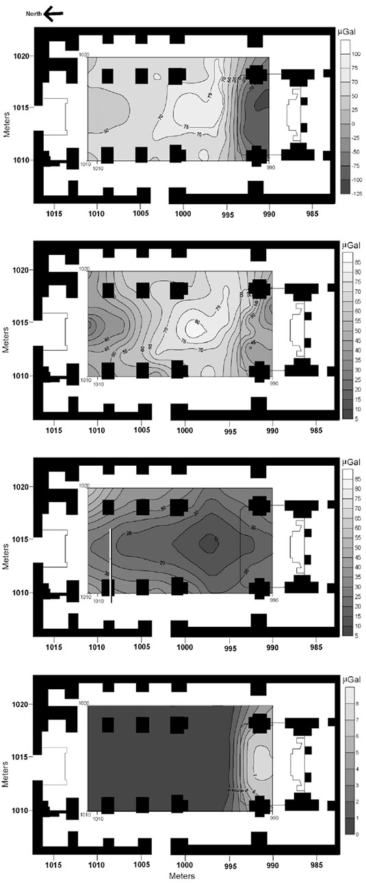 [Image: From “Archaeological microgravimetric prospection inside don church (Valencia, Spain),” by Jorge Padín, Angel Martín, Ana Belén Anquela, in a 2012 issue of the
  [Image: The church of San Sebastiano in Catania, Sicily, courtesy of the
 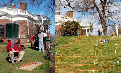 [Images: (left) An archaeologist examines soil cores. (right) Researchers plot lost roads across the grounds of Monticello. Courtesy of the
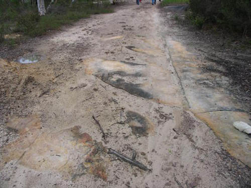
  [Image: Walking an “ancient road” in Vermont; photo by
 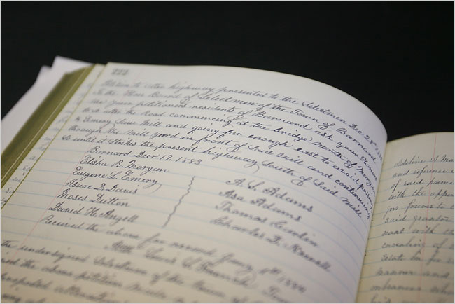 [Image: A hand-written inventory of Vermont’s ancient routes; photo by
 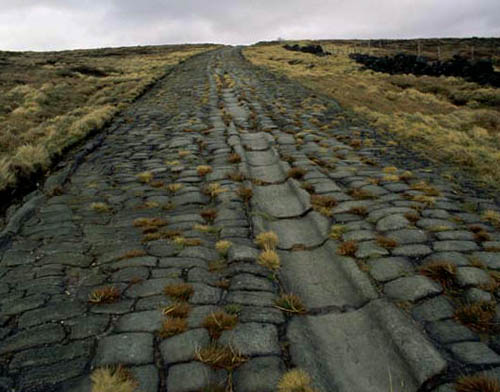 [Image: An old Roman road in Britain; photo via
 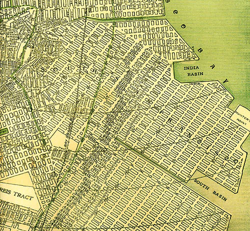 [Image: A map of San Francisco, including many “ghost streets,” courtesy of
 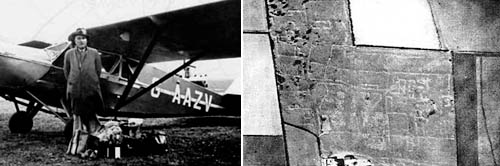 [Image: O.G.S. Crawford and his archaeological airplane; via Kitty Hauser’s
 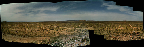 [Image: California City, CA; view
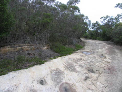
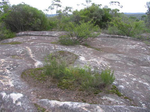
 [Image: Three views of Australia’s lost