Mechanical Magic

[Image: “Design for the Water Clock of the Peacocks,” from the Kitab fi ma’rifat al-hiyal al-handasiyya (Book of the Knowledge of Ingenious Mechanical Devices) by Badi’ al-Zaman b. al Razzaz al-Jazari, courtesy Metropolitan Museum of Art].

Although it starts in only a few hours, if you’re in the Bay Area tonight, it sounds well-worth attending this talk by Brittany Cox at The Interval: “Horological Heritage: Generating bird song, magic, and music through mechanism.” Cox “specializes in the conservation of automata, mechanical magic, mechanical music, and complicated clocks and watches.” The event opens at 6:30pm for a 7:30pm kick-off.

And, if magical, time-telling automata are not enough, The Interval has amazing drinks.

The Walled City (10-Mile Version)

[Image: “The Walled City (10-Mile Version)” by Andrew Kudless/Matsys].

A new exhibition opens next week at the Hubbell Street Galleries in San Francisco, part of the California College of the Arts, called Drawing Codes: Experimental Protocols of Architectural Representation. The idea behind the group show is to look at “the relationship between code and drawing” (emphases theirs), or “how rules and constraints inform the ways we document, analyze, represent, and design the built environment.”

Drawing Codes is curated by Andrew Kudless and Adam Marcus, with Clayton Muhleman, and it features work by Erin Besler, Elena Manferdini, Jimenez Lai, the Oyler Wu Collaborative, Rael San Fratello, and many more.

As Kudless—of Matsys fame—pointed out to me over email, the curators “gave all of the participants a set of codes that they had to follow (e.g. all black and white, orthographic projection, 25″ x 25″, etc.),” using this set of constraints to, among other things, foreground differences in approach between each participating architect.

If everyone’s doing the same thing, then how each person does it becomes more revealing.

[Image: “Half-Hearted Diamonds” by Jimenez Lai/Bureau Spectacular].

Perhaps ironically, it was actually the drawing by Kudless himself—which I first saw on Instagram—that caught my interest.

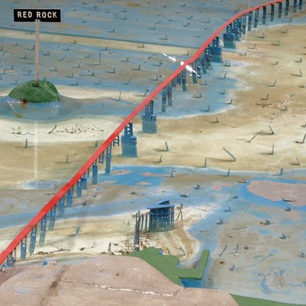
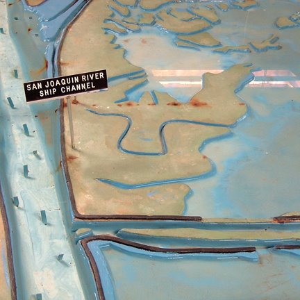
Called “The Walled City (10-Mile Version),” that project imagines an entire metropolis that is nothing but one, continuous wall.

Kudless explained that it came about by posing himself a rhetorical question: “What would a city look like if it was a wall and nothing else? I’ve been fascinated with walls that have grown thick enough to be buildings in themselves. From medieval European city walls to the Great Wall in China, there is something really interesting about taking something that is ostensively about separating two territories and turning into an inhabitable space in its own right.”

[Image: Close-up from “The Walled City (10-Mile Version)” by Andrew Kudless/Matsys].

The results: a rule-constrained exploration of how a wall could become a city.

I started to play around with slowly increasing a wall’s length while preventing it from moving outside a site or intersecting itself. At a certain point in the growth process, the wall takes over the entire site. There is still an inside and outside to the wall, but sometimes the outside is deep inside the site boundary or vice versa. At that point, I was left with a big squiggly wall, but realized that I needed some sort of roofscape to make it read as a city and not just a thick wall. That’s when I turned to Google’s autocomplete feature to give me suggestions on what programs [spatial functions] a rooftop might support. I worked my way from A to Z pretty much accepting whatever suggestion Google’s autocomplete gave me and started designing parametric definitions that could implement that program on a number of different sites along the wall’s top.

The various social and architectural functions distributed around the massive roofscape included, for example, Rooftop Antenna, Rooftop Bar, Rooftop Cafe, Rooftop Deck, Rooftop Exhaust, Rooftop Film, Rooftop Garden, Rooftop Hotel Pool, and so on.

Interestingly, Kudless also pointed out that, if he were to run the same generative script again, it would likely produce “a similar, but not identical city,” and it would almost certainly not result in a wall exactly ten miles in length (which, in this case, was purely a coincidence, he explained).

In any case, I’ve been impressed by Kudless’s work for a long time; check out these older posts on his projects Nevada Sietch and robotic drawing protocols, for example, and then stop by the exhibition when it opens next week. There will be a reception on January 19 at 5:30pm at 161 Hubbell Street. More info.

Local Code

[Image: Local Code by Nicholas de Monchaux].

Architect Nicholas de Monchaux—whom you might remember from, among other things, a long interview on BLDGBLOG a few years back—has a new book out this week.

[Image: Local Code by Nicholas de Monchaux].

Local Code is an exploration of design variants and latent possibilities in overlooked parcels of urban space. It is “as much design speculation as narrative (and as much obsession as exposition),” he explains.


[Images: Local Code by Nicholas de Monchaux].

The book includes no fewer than “3,659 drawings of designs (by me!) for vacant lots and spaces in New York City, Los Angeles, San Francisco, and the Venice Lagoon, highlighting how such spaces can play an essential and unique role in providing ecological, social, and cultural resilience. Inspired originally by Gordon Matta-Clark’s Fake Estates project, the book has become a graphic and intellectual meditation on cities, networks, data and resilience.”

[Image: Local Code by Nicholas de Monchaux].

The book’s thesis is that “vacant public land”—by which de Monchaux means everything from “land under billboards in Los Angeles, ­dead-end alleys in San Francisco, city-owned vacant lots in New York City, and abandoned islands in the Venetian lagoon”—actually contain “unrecognized potential as a social and ecological resource.” The accompanying explosion of drawings and diagrams is meant to tease out what some of these potentials might be.

Consider picking up a copy, check out the book’s introduction online, and don’t forget to click back to BLDGBLOG’s interview with de Monchaux about the design history of the Apollo spacesuit.

San Francisco Sub Hub

I’ve got a short post up over at Travel + Leisure about a speculative proposal to build a “submarine hub” at San Francisco’s Aquarium of the Bay that could be used as a base for exploring local seamounts, canyons, reefs, and escarpments. The post simultaneously looks at the pioneering undersea work of Sylvia Earle, who is involved with the project, and the utopian maritime architectural projects of groups such as Ant Farm.

Art Arm

[Image: “Untitled #13,” from “Scripted Movement Drawing Series 1” (2014) by Andrew Kudless].

San Francisco-based designer and architect Andrew Kudless is always up to something interesting, and one of his most recent projects is no exception.

For a new group of small works called “Scripted Movement Drawing Series 1” (2014), Kudless is exploring how robots might make visual art—in this specific case, by combining the instructional art processes of someone like Sol Lewitt with the carefully programmed movements of industrial machinery.

[Image: The robot at work, from “Scripted Movement Drawing Series 1” (2014) by Andrew Kudless].

In Kudless’s own words, “The work is inspired by the techniques of artists such as Sol Lewitt and others who explored procedural processes in the production of their work. The script, or set of rules, as well as the ability or inability of the robot to follow these instructions is the focus of the work. There is almost a primitive and gestural quality to the drawings created through the tension between the rules and the robot’s physical movement. Precisely imprecise.”

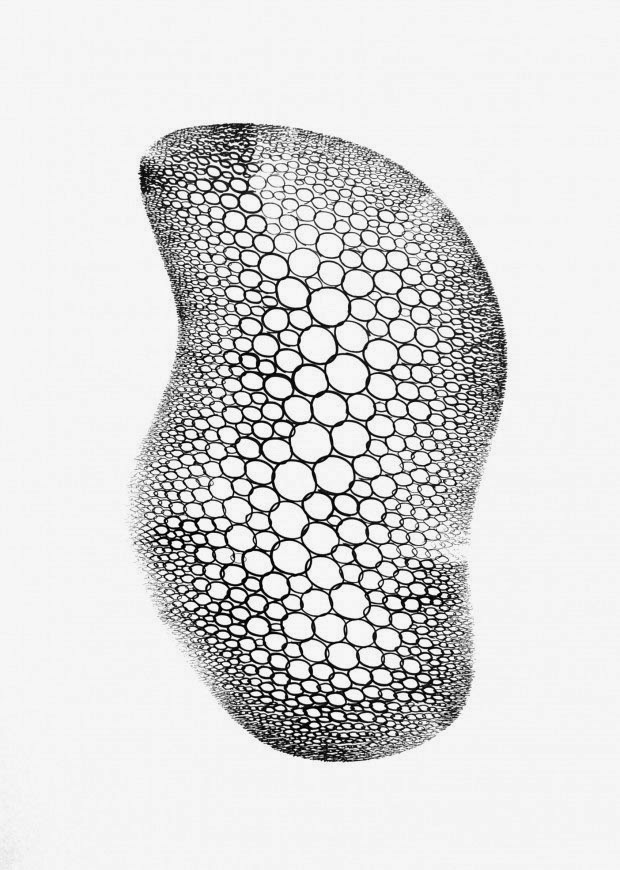
[Image: “Untitled #16,” from “Scripted Movement Drawing Series 1” (2014) by Andrew Kudless].

These giant robot arms, he continues, “are essentially larger, stronger, and more precise version of the human arm. Made up of a series of joints that mimic yet extend the movements of shoulder, elbow, and wrist, the robot has a wide range of highly control[led] motion. The real value of these robots is that, like the human arm, their usefulness is completely determined by the tool that is placed in its hand.”

So why only give robots tools like “welding torches, vacuum grippers, and saws,” he asks—why not give them pencils or brushes?

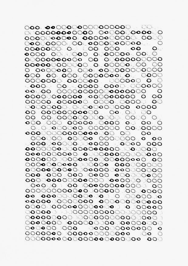
[Image: “Untitled #6 (1066 Circles each Drawn at Different Pressures at 50mm/s),” from “Scripted Movement Drawing Series 1” (2014) by Andrew Kudless].

The results are remarkable, but it’s specifically the unexpected combination of Lewittian instructional art with industrial robotics that I find so incredibly interesting. After all, Kudless ingeniously implies, it has always been the case that literally all acts of industrial assembly and production are, in a sense, Sol Lewitt-like activities—that conceptual art processes are hiding in plain sight all around us, overlooked for their apparent mundanity.

It’s as if, he suggests, every object fabricated—every car body assembled—has always and already been a kind of instructional readymade, or Sol Lewitt meets Marcel Duchamp on the factory floor.

With these, though, Kudless throws in some Agnes Martin for good measure, revealing the robot arms’ facility for minimalist lines and grids in a graceful set of two-dimensional drawings.

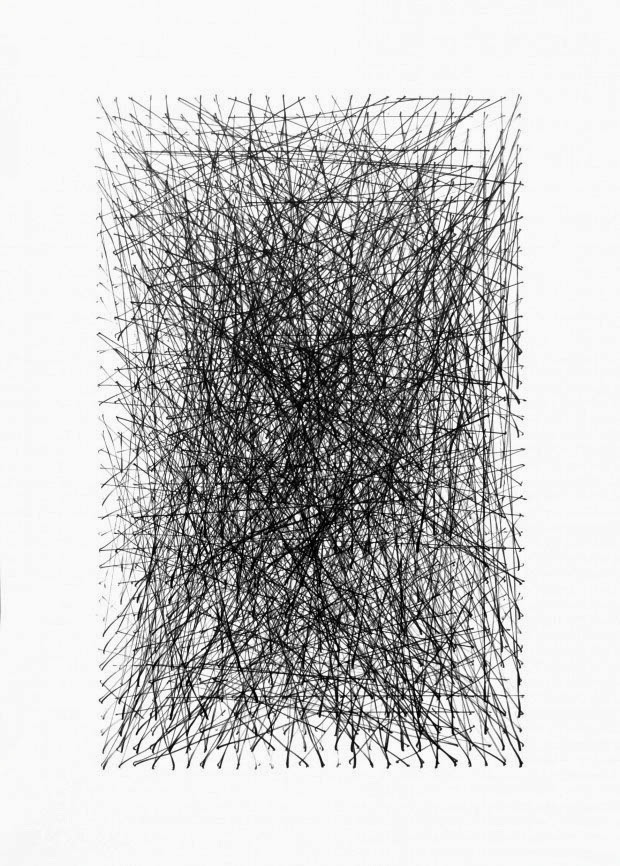
[Image: “Untitled #7 (1066 Lines Drawn between Random Points in a Grid),” from “Scripted Movement Drawing Series 1” (2014) by Andrew Kudless].

Kudless explains that “each of the works produced in this series was entirely programmed and drawn through software and hardware”:

None of the lines or curves was manually drawn either within the computer or in physical reality. Rather, I created a series of different scripts or programs in the computer that would generate not only the work shown here, but an infinite number of variations on a theme. Essential to the programming was understanding the relationships between the robot and human movement and control. Unlike a printer or plotter which draws from one side of the paper to the other, the robot produces the drawings similarly to how a human might: one line at a time. The speed, acceleration, brush type, ink viscosity, and many other variables needed to be considered in the writing of the code.

Various drawing styles were chosen to showcase this.

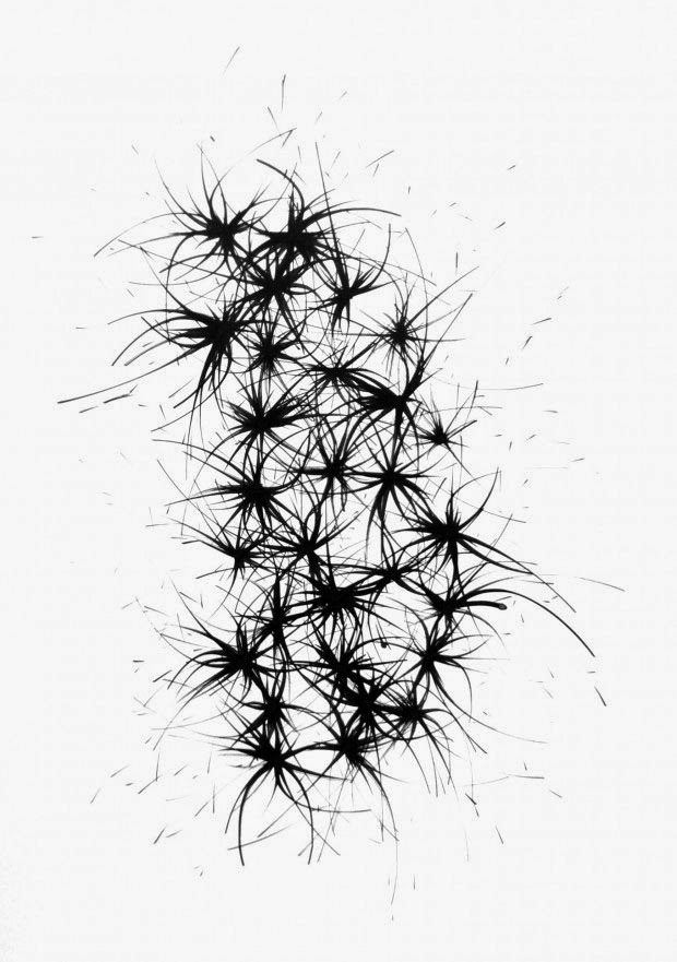
[Image: “Untitled #15 (Twenty Seven Nodes with Arcs Emerging from Each),” from “Scripted Movement Drawing Series 1” (2014) by Andrew Kudless].

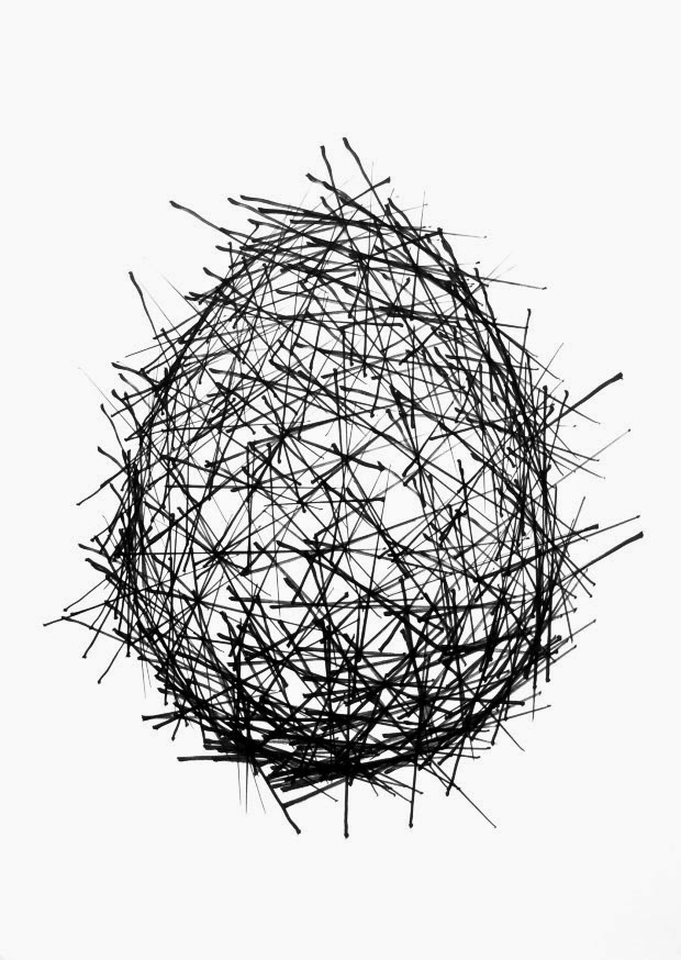
[Image: “Untitled #3 (Extended Lines Drawn from 300 Points on an Ovoid to 3 Closest Neigh[bor]ing Points at 100mm/s)” (2014) from “Scripted Movement Drawing Series 1” (2014) by Andrew Kudless].

[Image: “Untitled #12,” from “Scripted Movement Drawing Series 1” (2014) by Andrew Kudless].

[Image: “Untitled #14,” from “Scripted Movement Drawing Series 1” (2014) by Andrew Kudless].

There are many more drawings visible on Kudless’s website, and I am already looking forward to “Scripted Movement Drawing Series 2.”

You can also purchase one of the prints, if you are so inclined; contact the Salamatina Gallery for more information.

(Very vaguely related: Robotism, or: The Golden Arm of Architecture).

The City and its Periphery

If you’re in the Bay Area at the end of month, consider attending an event called Macro City, organized and hosted by the Infrastructure Observatory. Its purpose is “to explore the vast, often overlooked networks of infrastructure that surround us,” and, in the process, “to celebrate the numerous people whose countless efforts shape the built landscape every day.”

Probably the most interesting part of the whole event is the ambitious program of local field trips, all of which take place on May 30th. They include guided tours of everything from the Zanker landfill & recovery facility down in San Jose to one of San Francisco’s wastewater treatment plants, and from a construction aggregate terminal and a kayak trip to an activist walking tour of the city’s many surveillance cameras.

[Image: The Dutra Group‘s extraordinary San Rafael rock quarry, a Macro City field trip site and striking reversal of the figure-ground relationship; photo courtesy of baycrossings/Macro City].

Tickets are available at various levels of price and access—and I should point out that I am also speaking at the event, alongside Nicola Twilley, so my opinion betrays some bias—but the conference has a great and important interpretive mission, and seems well worth attending: “We rarely see in full the cities that we live in,” the organizers write. “Focused on our daily lives, urban dwellers are often only dimly aware of the numerous, enmeshed layers of critical infrastructure that quietly hum in the background to make modern life possible.”

Come tour and talk about those hidden systems on May 30 and 31, at SPUR and the Brava Theater in San Francisco. See the Macro City site for more details.

Where does your taco come from?

Like a culinary version of Sourcemap, Rebar has teamed up with landscape architect David Fletcher and some students from the increasingly interesting California College of the Arts in San Francisco to explore the ingredients of your local taco—from pinto beans to the aluminum foil it all comes wrapped in.

Our premise was that a seemingly simple, familiar food like the taco truck taco could provide visceral insight into the connections between the systems we were exploring [in our studio’s investigation of the city]. By thoroughly learning the process of formation and lifecycle for what it takes to make a taco, we would be better able to propose and design a speculative model of a holistic and sustainable urban future. What resulted was a richly complex network of systems, flows and ecologies that we call the global Tacoshed.

This is a participatory undertaking; meet at the Studio for Urban Projects in San Francisco at 7pm on Thursday, February 25, to find out how you, too, can map a taco. Here’s a map.

The Studio for Urban Projects, meanwhile, has a pretty fascinating list of previous endeavors, including Foodshed, Strange Weather, and the awesome Unnatural History of Golden Gate Park. Large parts of what are now west San Francisco were once covered by nomadic sand dunes, a kind of peninsular erg; that granular presence is now only temporarily locked in place beneath the foundations of houses. Every grain you see blowing down a San Franciscan street is this lost geography attempting to reassert itself.

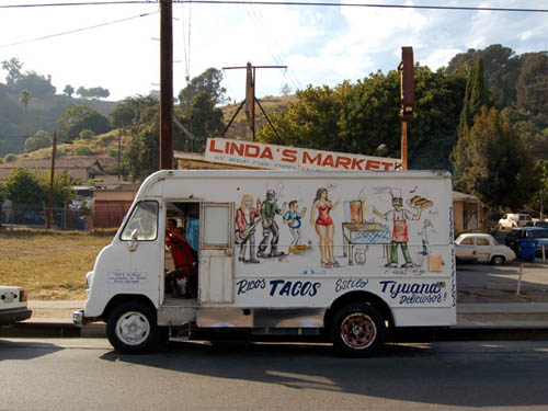
[Image: “There are two basic types of taco trucks,” we read; “the first and most common is the transient truck which is a truck that stops at approximately 20 different locations at 20-minute intervals during an 8-hour shift, typically beginning at 6am and ending at 2pm. The second type is the semi-permanent truck, which is a truck that has found a location that has a density of clientele to sustain it for an extended period of the day, creating a nearly fixed presence in a particular community.” From Polar Inertia].

And I can’t let this post end without calling attention to the excellent—in fact, extraordinary—Polar Inertia, specifically its photo-essay published more than four years ago tracing the taco-truck geography of greater Los Angeles. These dispersed infrastructures might now be quite trendy, but the functional networks things like taco trucks actually form on the streets of our cities are still worth mapping in full.

San Francisco Bay Hydrological Model

In Sausalito, CA, near a 7-11, one finds the San Francisco Bay Hydrological Model.


The Bay Model was built in 1957 by the Army Corps of Engineers; it is “over 1.5 acres in size and represents an area from the Pacific Ocean to Sacramento and Stockton, including: the San Francisco, San Pablo and Suisun Bays and a portion of the Sacramento-San Joaquin Delta.” Which means it’s larger than two American football fields. (I think).


The Model served “as a scientific research tool from 1958-2000 to evaluate circulation and flow characteristics of the water within the estuary system,” allowing Army Engineers “to simulate currents, tidal action, sediment movement and the mixing of fresh and salt water. Pollution, salt-water intrusion, barrier and fill studies were a few of the important research projects that have been undertaken at the Bay Model.”
It’s not in the greatest condition, and the faded primary color scheme leaves something to be desired, but the model is no less fascinating for that; any chance you get to walk the shores of a microcosm is a good chance to do some thinking.


If I may briefly quote William Blake

To see a world in a grain of sand
And a heaven in a wild flower
Hold infinity in the palm of your hand
And eternity in an hour

– I’ll then point out that the Bay Model exists within its own timezone: in the world of the Model, one day passes every 14.9 minutes. 30 full days elapse every 7.2 hours. Complete tidal cycles run 3.8 minutes. You can practically feel yourself aging in the presence of this copyscape, its wetlands and alluvial braids of artificial rivers running through fields of pumps and power cords.
Look closely and you’ll see a “Tide Hut” where little gods of the Model enact catastrophe and unleash floods upon the surrogate world spread out before them. Look closer, and you’ll see damage from a “hundred years of waves, subsidence, and boat wakes” – which, in Model time, is almost exactly one human year.


But I soon got to thinking about the politics of architectural models. Imagine what would happen, for instance, if some Navy SEALS raided a cave in Afghanistan and found the Bay Model sitting there: what on earth does al-Qaeda want with San Francisco’s water supply? FOX News screams. Or a model of Greater London’s Thames hydrology, complete with flood gates, Barriers and overflow sewers, which is one thing if it’s in the possession of Tony Blair, and quite another if found in the basement of, say, Abu Hamza or even Timothy McVeigh.
What were they trying to do with it?
It’s the politics of architectural models: an object of scientific curiosity in one person’s hands is an issue of national security in another’s.
Or: simulacra as a threat to national security.
A plot for a new Philip K. Dick novel, or a film by Charlie Kauffman, then came to mind: a man, perhaps a young Al Pacino, breaks into the Bay Model in the middle of the night. He barricades himself inside, turns on the power, and starts flooding the model, demolishing bridges, rerouting estuarial confluences. He jumps up and down, causing modelquakes, and then accelerates the tides, obliterating Golden Gate Park under the force of a single wave.
He calls all the local newspapers and takes responsibility for the disasters now befalling San Francisco outside; but what disasters? they ask, and he thinks they’re conning him, denying his rage, because he’s read William Blake and St. Thomas Aquinas and he believes that everything he throws at that simulacrum there before him will have effects in the real world…
Because it’s all building up to one moment, see, the big moment when he decides to flood the Bay Model’s model of the Bay Model, opening up a rift in the universe and blasting him head-first through the macrocosm.
Until the police break-in…

(Thanks to Chad for the tip, and to Nicola for coming with me!)