
 The so-called “Yolo Buggy” was not a 19th-century adventure tourism vehicle for those of us who only live once; it was a mobile building, field shelter, and geopolitical laboratory for measuring the borders of an American county. Yolo County, California.
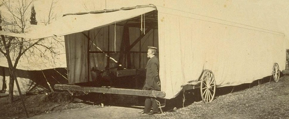 The “moveable tent or ‘Yolo Buggy,'” as the libraries at UC Berkeley describe it, helped teams of state surveyors perform acts of measurement across the landscape in order to mathematically understand—and, thus, to tax, police, and regulate—the western terrain of the United States. It was a kind of Borgesian parade, a carnival of instruments on the move.
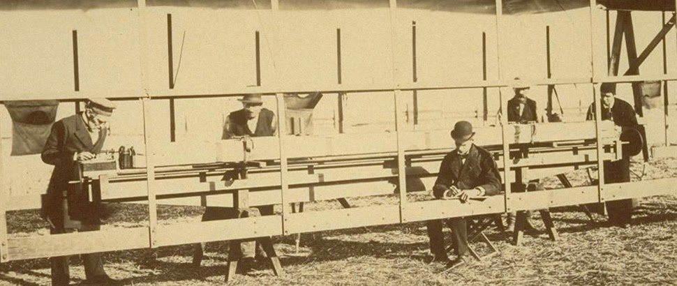
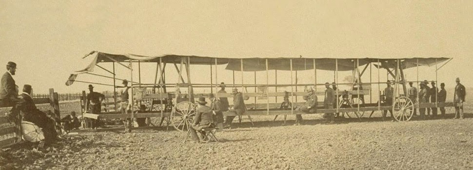 The resulting “Yolo Baseline” and the geometries that emerged from it allowed these teams to establish a constant point of cartographic reference for future mapping expeditions and charts. In effect, it was an invisible line across the landscape that they tried to make governmentally real by leaving small markers in their wake. (Read more about meridians and baselines over at the Center for Land Use Interpretation).
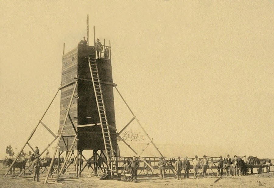
 In the process, these teams carried architecture along with them in the form of the “moveable tent” seen here—which was simultaneously a room in which they could stay out of the sun and a pop-up work station for making sense of the earth’s surface—and the related tower visible in the opening image.
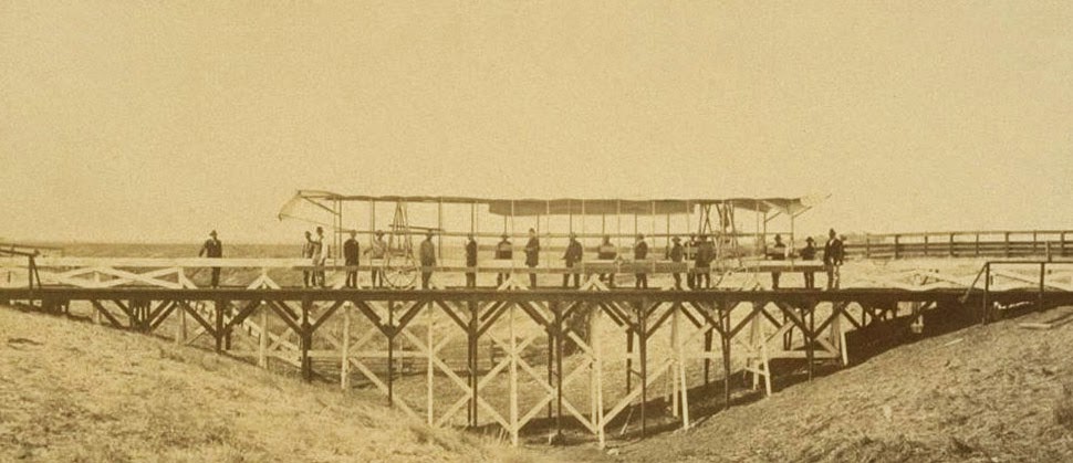 That control tower allowed the teams’ literal supervisors to look back at where they’d come from and to scan much further ahead, at whatever future calculations of the grid they might be able to map in the days to come. You could say that it was mobile optical infrastructure for gaining administrative control of new land.
 Like a dust-covered Tron of the desert, surrounded by the invisible mathematics of a grid that had yet to be realized, these over-dressed gentlemen of another century helped give rise to an abstract model of the state. Their comparatively minor work thus contributed to a virtual database of points and coordinates, something immaterial and totally out of scale with the bruised shins and splintered fingers associated with moving this wooden behemoth across the California hills.
(All images courtesy UC Berkeley/Calisphere).
Great post. Its striking, at least to me, that a similar feeling – this tron of the desert surrounded by invisible mathematics – is palpable when driving out of LA on the 10 east into the desert and seeing the city recede into desert but knowing that all the 'empty' desert is very controlled, at least on a political level.
What a treat to come across this post. I have been developing some ideas on mobility and work and this is a fantastic example from long ago.
Thanks
Doug Wittnebel
But these dudes were just exploring a wasteland that people knew little about!
Point of pedantry: these would be members of the Coast and Geodetic Survey laying out and measuring a baseline for triangulation — which is not the same as the "baselines and meridians" used in the US Public Land Survey System (the rectangular surveys). The PLSS is cadastral, this is geodetic/cartographic.
An important clarification—thanks!
Please remove the statement: "Their comparatively minor work…"
The Yolo Buggy was instrumental in the creation of 'The Yolo Base Line, 1881' which was the beginning of the Triangulation of the 39th Parallel. It was the first time the curvature of the Earth was measured, AND the accurate size of the planet. When compared to modern day measurements, in 1881 they were off by less than 10 millimeters! Please give this famous team of International surveyors the respect they deserve. John Muir was the naturalist and their guide for this project. The geodetic markers they placed still exist, and the first one, the most important one, which was at the beginning of the 'Yolo Base Line, 1881', is a mile away from where I sit now, I saw it again yesterday. It is an incredibly important piece of local as well as global history. One of the biggest stories in the world in fact. It was the most accurate survey ever done in history up to that time. These men are heroes in their own right.
Please feel free to email or call me for further information, I am doing an in depth history of this project.
Monica Ballyurban
Davis, CA
c: 530-204-3898
monicabu@earthlink.net
Thank You for the wonderful pictures. I wish I knew what happened to the Yolo Buggy. Perhaps your website will help us one day find out!