Desk Crit

[Image: The lyrics from “Desk Crit” by Crash Cadet].

Recent architecture grad Joshua Rathbun has released an album under the name Crash Cadet, called Lists Are Good. While the album is worth giving a spin—though it’s not normally the kind of music I listen to—the specific track “Desk Crit” is the most architecturally-influenced of the bunch. Check it out on Soundcloud, then consider purchasing the album from the Crash Cadet site. This is perhaps what Benoît Pioulard would sound like if he had gone to the GSD.

The Reforestation of the Thames Estuary

[Image: “The Dormant Workshop” by Tom Noonan, courtesy of the architect].

While studying at the Bartlett School of Architecture in London, recent graduate Tom Noonan produced a series of variably-sized hand-drawings to illustrate a fictional reforestation of the Thames estuary.

[Image: “Log Harvest 2041” by Tom Noonan, courtesy of the architect].

Stewarding, but also openly capitalizing on, this return of woodsy nature is the John Evelyn Institute of Arboreal Science, an imaginary trade organization (of which we will read more, below).

[Image: “Reforestation of the Thames Estuary” by Tom Noonan, courtesy of the architect].

The urban scenario thus outlined—imagining a “future timber and plantation industry” stretching “throughout London, and beyond”—is like something out of Roger Deakin’s extraordinary book Wildwood: A Journey Through Trees (previously described here) or even After London by Richard Jeffreys.

In that latter book, Jeffreys describes a thoroughly post-human London, as the ruined city is reconquered by forests, mudflats, aquatic grasses, and wild animals: “From an elevation, therefore,” Jeffreys writes, “there was nothing visible but endless forest and marsh. On the level ground and plains the view was limited to a short distance, because of the thickets and the saplings which had now become young trees… By degrees the trees of the vale seemed as it were to invade and march up the hills, and, as we see in our time, in many places the downs are hidden altogether with a stunted kind of forest.”

Noonan, in a clearly more domesticated sense—and it would have been interesting to see a more ambitious reforestation of all of southeast England in these images—has illustrated an economically useful version of Jeffreys’s eco-prophetic tale.

[Image: “Lecture Preparations” by Tom Noonan, courtesy of the architect].

From Noonan’s own project description:

The reforestation of the Thames Estuary sees the transformation of a city and its environment, in a future where timber is to become the City’s main building resource. Forests and plantations established around the Thames Estuary provide the source for the world’s only truly renewable building material. The river Thames once again becomes a working river, transporting timber throughout the city.

It is within these economic circumstances that the John Evelyn Institute of Arboreal Science can establish itself, Noonan suggests:

The John Evelyn Institute of Arboreal Scienc eat Deptford is the hub of this new industry. It is a centre for the development and promotion of the use of timber in the construction of London’s future architecture. Its primary aim is to reintroduce wood as a prominent material in construction. Through research, exploration and experimentation the Institute attempts to raise the visibility of wood for architects, engineers, the rest of the construction industry and public alike. Alongside programmes of education and learning, the landscape of the Institute houses the infrastructure required for the timber industry.

They are similar to an organization like a cross between TRADA and the Wooodland Trust, say.

[Image: “Urban Nature” by Tom Noonan, courtesy of the architect].

And the Institute requires, of course, its own architectural HQ.

[Image: “Timber Craft Workshop” by Tom Noonan, courtesy of the architect].

Noonan provides that, as well. He describes the Institute as “a landscape connecting Deptford with the river,” not quite a building at all. It is an “architecture that does not conform to the urban timeframe. Rather, its form and occupation is dependent on the cycles of nature.”

The architecture is created slowly—its first years devoid of great activity, as plantations mature. The undercroft of the landscape is used for education and administration. The landscape above becomes an extension of the river bank, returning the privatised spaces of the Thames to the public realm. Gaps and cuts into the landscape offer glimpses into the monumental storage halls and workshops below, which eagerly anticipate the first log harvest. 2041 sees the arrival of the first harvest. The landscape and river burst in a flurry of theatrical activity, reminiscent of centuries before. As the plantations grow and spread, new architectures, infrastructures and environments arise throughout London and the banks of the Thames, and beyond.

The drawings are extraordinary, and worth exploring in more detail, and—while Noonan’s vision of London transformed into a working forest plantation would have benefitted from some additional documentation, such as maps*—it is a delirious one.

[Image: “Thames Revival” by Tom Noonan, courtesy of the architect].

Considering the ongoing overdose of urban agriculture imagery passing through the architecture world these days, it is refreshing simply to see someone hit a slightly different note: to explore urban forestry in an aesthetically powerful way and to envision a world in which the future structural promise of cultivated plantlife comes to shape the city.

*I wrote this without realizing that the package of images sent to me did not include the entire project—which comes complete with maps.

Church of Planets Past

[Image: Photo courtesy of Andrea Tintori and Discovery News].

I love this story: the polished rock walls of a Catholic church in northern Italy have been found to contain the skull of a dinosaur. “The rock contains what appears to be a horizontal section of a dinosaur’s skull,” paleontologist Andrea Tintori explained to Discovery News. “The image looks like a CT scan, and clearly shows the cranium, the nasal cavities, and numerous teeth.”

The skull itself was hewn in two; “indeed,” we read, “Tintori found a second section of the same skull in another slab nearby.”

[Image: Photo courtesy of Andrea Tintori and Discovery News].

The rock itself—called Broccatello—comes from a fossil-rich quarry in southern Switzerland and dates back to the Jurassic. According to the book Fossil Crinoids, “The Broccatello (from brocade) was given its name by stone masons; this flaming, multicoloured ‘marble’ has been used in countless Italian and Swiss baroque and rococo churches”—implying, of course, that other fossil finds are waiting to be found in Alpine baroque churches. “In the quarries of Arzo, southern Switzerland,” the book continues, “crinoids [the fossilized bodies of ancient marine organisms] account for up to half of the bulk of the Broccatello, which is usually a few metres thick.”

In any case, to figure out exactly what kind of dinosaur it is, the rock slab might be removed from the church altogether for 3D imaging in a lab; a new piece of Broccatello rock, mined from southern Switzerland, could be use as its replacement.

The larger idea of discovering something historically new and even terrestrially unexpected in the rocks of a city, or in the walls of the buildings around you—as if the most important fossil site in current geology might someday be the rock walls of a ruined castle and not a cliff face or gorge—brings to mind recent books like Richard Fortey’s fantastic Earth: An Intimate History, with its geological introduction to sites like Central Park, Stories in Stone: Travels Through Urban Geology, and the Geologic City Reports (Parts 1, 2, 3, 4, 5, and 6) by Friends of the Pleistocene. These latter research files present New York City through the lens of its lumpen underpinnings, focusing on bedrock, mineral veins, and salt, not the city’s cultural districts or ethnic history.

But, of course, the H.P. Lovecraftian overtones of this story—a monstrous skull in a church wall—are too obvious not to mention: an easy scenario for imagining whole plots and storylines in which the ancient forms of an unknown species are discovered hidden in cathedral masonry, opening previously unimagined horizons of time and radically revising theories of the history of life on earth.

I just absolutely love the idea that a piece of architecture can become a site for paleontological research, framing an unlikely forensic study of the earth’s biological past.

The Access Maze

[Image: A fenced-off, back alley security stair in Toronto, via
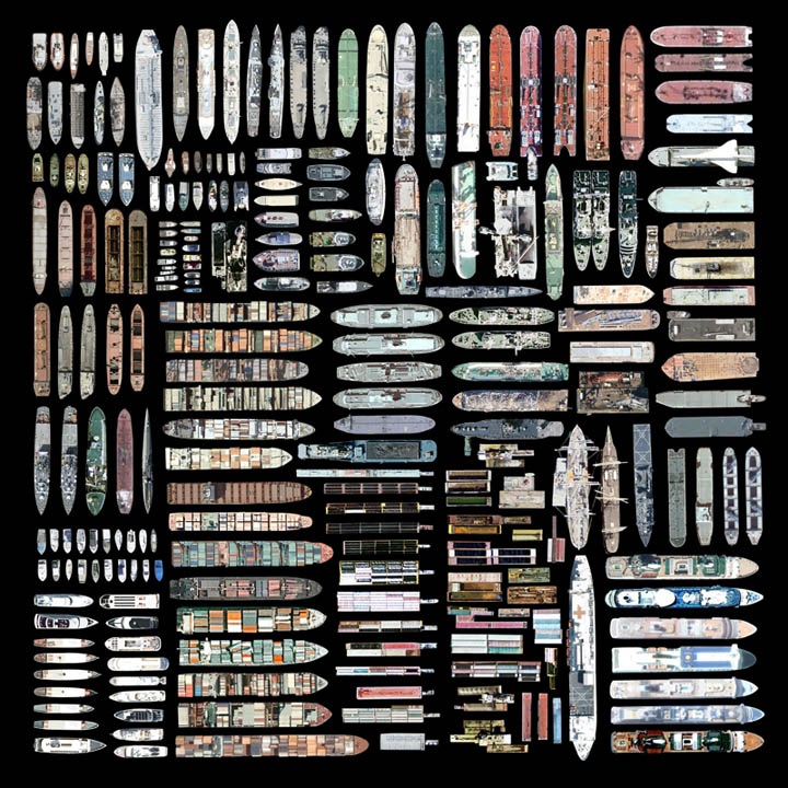
 Google Street View; view larger].

A link on Twitter from Andrew Lovett-Barron led me to this otherwise innocuous fenced-in back alley staircase in Toronto, pictured here via Google Street View (view larger).

There’s something oddly compelling about this minor architecture of out-of-place private access—as if implying that buildings could begin blocks and blocks away from where they actually rest in urban space, splayed out into the neighborhoods around them like chain-linked octopi, reaching out with stairways, doors, and catwalks across the roofs and back streets of the city. A Home Depot vernacular stretched to Berlin Wall-like proportions.

You don’t like your address, you simply hurl a chain-linked access stair up over and out to whatever street you prefer—and you enter there, turning a key and stepping into a steel maze of steps and ladders, cantilevered walkways and pillared decks. Fifteen minutes later, passing over and beneath ribbons of other parallel geographies, looping down alleys and nesting briefly on thin platforms in the canopies of trees, walking alone in this isolated cocoon like a private enclave in the city, you’re home.

Buy an Archipelago

Another story I meant to link here long ago is this real estate listing for an entire Scottish archipelago.

For £250,000—approximately $398,000—you can be the owner of “a wonderful and remote island group… a small archipelego centred around two main islands 25 miles north east of Lerwick, Shetland and extending to about 600 acres in all.” It comes complete with a “private airstrip” and seasonal wild flowers.

Perhaps you want to establish a writers’ residence. Perhaps you’re fed up. Perhaps you want to declare a private city-state. Or perhaps you simply want to reinvigorate the struggling private island market.

Whatever the case may be, “a charter flight can also be arranged from Tinwall just to the north of Lerwick.”

[Earlier on BLDGBLOG: Buy a Map, Buy a Torpedo-Testing Facility, Buy a Fort, Buy a Church, and Buy a Silk Mill].

Buy a Map

[Image: Photo by Barney Peterson, courtesy of the San Francisco Chronicle].

Something I meant to post three few weeks ago, before October became the Great Lost Month of constant busyness and over-commitment, is the story of a 70-ton relief map of California, unseen by the public for half a century, that has been re-discovered in San Francisco, sitting in “an undisclosed location on the city’s waterfront.”

[Image: Photo by Barney Peterson, courtesy of the San Francisco Chronicle].

In its time, the map was considered far too marvelous for simply cutting up and storing—but that’s exactly what’s happened to it.

It was as long as two football fields and showed California in all its splendor, from Oregon to Mexico, with snow-capped mountains, national parks, redwood forests, a glorious coastline, orchards and miniature cities basking in the sun. It was made of plaster, wire, paint, and bits of rock and sand. In the summer of 1924, Scientific American magazine said it was the largest map in the world.

However, we read, “The problem with the map is simple: it is huge and would cost a lot of money to move, restore and display it. The last estimate was in the range of $500,000. And that was 30 years ago. It is a classic white elephant, too valuable to scrap, but too expensive to keep.”

And, today, it’s not going anywhere: “The Port of San Francisco has no plans to be anything but stewards of its storage, and no one else has come forward in half a century to rescue the map.” If you have half-a-million dollars or so, and heavy moving equipment at your disposal, then perhaps it could soon be yours.

(Thanks to Steve Silberman for the link. In the archives: San Francisco Bay Hydrological Model; Buy a Torpedo-Testing Facility, Buy a Fort, Buy a Church, and Buy a Silk Mill].

Softcore

Just a quick reminder that you have till December 10 to submit to Bracket 2, published by Actar, Archinect, and InfraNet Lab:

Bracket 2 invites the submission of critical articles and unpublished design projects that investigate physical and virtual soft systems, as they pertain to infrastructure, ecologies, landscapes, environments, and networks… Bracket 2 seeks to critically position and define soft systems, in order to expand the scope and potential for new spatial networks, and new formats of architecture, urbanization and nature. From soft politics, soft power and soft spaces to fluid territories, software and soft programming, Bracket 2 questions the use and role of responsive, indeterminate, flexible, and immaterial systems in design. Bracket 2 invites designers, architects, theorists, ecologists, scientists, and landscape architects to position and leverage the role of soft systems and recuperate the development of the soft project.

Check out InfraNet Lab and the Bracket website for more info. Keep your eye out, as well, for InfraNet Lab‘s forthcoming Pamphlet Architecture installment, Coupling: Strategies for Infrastructural Opportunism.

The Museum of Speculative Archaeological Devices

Perhaps a short list of speculative mechanisms for future archaeological research would be interesting to produce.

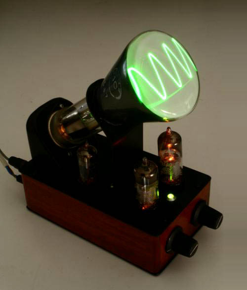
[Image: A toy antique oscilloscope by Andrew Smith, courtesy of Gadget Master and otherwise unrelated to this post].

Ground-scanners, Transparent-Earth (PDF) eyeglasses, metal detectors, 4D earth-modeling environments used to visualize abandoned settlements, and giant magnets that pull buried cities from the earth.

Autonomous LIDAR drones over the jungles of South America. Fast, cheap, and out of control portable muon arrays. Driverless ground-penetrating radar trucks roving through the British landscape.

Or we could install upside-down periscopes on the sidewalks of NYC so pedestrians can peer into subterranean infrastructure, exploring subways, cellars, and buried streams. Franchise this to London, Istanbul, and Jerusalem, scanning back and forth through ruined foundations.

Holograph-bombs—ArchaeoGrenades™—that spark into life when you throw them, World of Warcraft-style, out into the landscape, and the blue-flickering ancient walls of missing buildings come to life like an old TV channel, hazy and distorted above the ground. Mechanisms of ancient light unfold to reveal lost architecture in the earth.

[Image: An LED cube by Pic Projects, otherwise unrelated to this post].

Or there could be football-field-sized milling machines that re-cut and sculpt muddy landscapes into the cities and towns that once stood above them. A peat-bog miller. Leave it operating for several years and it reconstructs whole Iron Age villages in situ.

Simultaneous milling/scanning devices that bring into being the very structures they claim to study. Ancient fortifications 3D-printed in realtime as you scan unreachable sites beneath your city’s streets.

Deep-earth projection equipment that impregnates the earth’s crust with holograms of missing cities, outlining three-dimensional sites a mile below ground; dazed miners stumble upon the shining walls of imaginary buildings like a laser show in the rocks around them.

Or a distributed iPhone app for registering and recording previously undiscovered archaeological sites (through gravitational anomalies, perhaps, or minor compass swerves caused by old iron nails, lost swords, and medieval dining tools embedded in the ground). Like SETI, but archaeological and directed back into the earth. As Steven Glaser writes in the PDF linked above, “We can image deep space and the formation of stars, but at present we have great difficulty imaging even tens of meters into the earth. We want to develop the Hubble into, not away from, the earth.”

Artificially geomagnetized flocks of migratory birds, like “GPS pigeons,” used as distributed earth-anomaly detectors in the name of experimental archaeology.

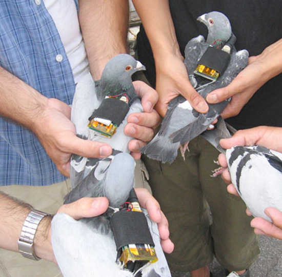
[Image: “GPS pigeons” by Beatriz da Costa, courtesy of Pruned].

So perhaps there could be two simultaneous goals here: to produce a list of such devices—impossible tools of future excavation—but also to design a museum for housing them.

What might a museum of speculative archaeological devices look like? A Mercer Museum for experimental excavation?

(Thanks to Rob Holmes and Alex Trevi for engaging with some of these ideas over email).

Trap Rooms Redux

[Image: An old asylum and its floorplan, courtesy of the University of Massachusetts at Dartmouth, otherwise unrelated to the present post].

We recently looked at the phenomenon of trap rooms, but that same idea came to mind again while reading about an interestingly architectural anxiety.

Amongst the many illnesses pushed to the limit by schizophrenic judge Daniel Paul Schreber—a figure who should be familiar to all readers of Deleuze & Guattari—was a kind of architectural paranoia. That is, Judge Schreber suffered an “anxious concern,” as Victoria Nelson explains in her book The Secret Life of Puppets, “about the physical layout of the clinics in which he was housed (whose floor plans he includes in the Memoirs) and his occasional conviction that he was in a room that ‘does not tally with any one of the rooms known to me’ in the asylum.”

He was inside the building, sure—but he was inside something else, an architectural circumstance he could neither abstractly understand nor spatially fathom. Perhaps, we might say, it was a trap room: a space neither here nor there, off the plan entirely, part of the very structure it will remain forever outside of.

The Migration of Mel and Judith

[Image: From “The Migration of Mel and Judith” by Thomas Hillier].

Thomas Hillier, of Emperor’s Castle fame, has sent in a newly documented but chronologically older project of his called “The Migration of Mel and Judith.”

The Migration of Mel and Judith,” Hillier writes, “was the pre-cursor to The Emperor’s Castle and my first real exploration into using narrative as the vehicle for generating and scrutinizing my architectural ideas. It was also where I began using craft-based techniques and 2/3-dimensional assemblage to illustrate the design process.”

The Migration, though, is not only an entire storyline packaged inside a beautifully realized, miniature architectural world—it’s also told inside a lampshade.

[Images: From “The Migration of Mel and Judith” by Thomas Hillier].

Mel and Judith, Hillier explains, are “a recently retired couple from Croydon who have decided to give up on their life in London’s third City and travel Europe,” looking for a place to touch down for a while (and for better weather).

[Images: From “The Migration of Mel and Judith” by Thomas Hillier].

Soon enough, though, they get homesick—and the architectural transformation of their caravan-home begins:

To combat thier longing they slowly adapt and customise their caravan-house to feel a little more like home. Walls of the caravan become aroma filled bricks of white bread, especially made by Mel & Judith themselves. Other adaptations include the pebbledash façade reminiscent of their Croydon abode. A green lawn-carpet that is much cooler underfoot than the hot Marbella sand and when it gets too hot there’s always the sprinkler system and snow-chimney.

The couple’s mobile slice of English domesticity becomes all but entombed beneath the ornament of personal nostalgia.

[Images: From “The Migration of Mel and Judith” by Thomas Hillier].

This, too, steeped in English nostalgia, becomes too staid for them, and the couple decides to leave Europe altogether, alighting for the more exotic climes of Luxor, Egypt.

[Image: From “The Migration of Mel and Judith” by Thomas Hillier].

There, they settle “on a small, uninhabited island situated on the River Nile, where in their weird and wonderful ‘Do-It-Yourself’ English manor Mel brews beer in his bathtub-brewery whilst Judith bakes rose-bread in the bread-garden.”

Their island comes alive during the holiday season creating an English retreat in the middle of Luxor, a retreat that lures in English tourists with the opportunity to be surrounded by the sights, sounds and smells of home. The smell of roses and freshly baked bread drift through the air whilst the temptation to drink beer (which is illegal in Luxor) is impossible to resist.

Maps of riverine estuaries have thus been sewn into the lampshade alongside windfarms, fishing boats, photo-collages, and even a portrait of Princess Diana.

[Images: From “The Migration of Mel and Judith” by Thomas Hillier].

If you pull back, though, and look at the whole project within its physical and visual frame, the self-enclosed curling world of the lampshade adds a wonderfully anti-perspectival, frilly concavity to the couple’s journey. These latter scenes become both explosive and disorienting.

Like the spaceships in Stanley Kubrick’s film 2001, the walls of their representational frame simply turn and turn, bringing us over and over again back through the same space, as if unwilling to let go of what’s come before. Here, that space is asprawl with tidal flats and marshlands, fishing spots and coves. The couple, living now in Luxor, welcome visitors, dry their clothes aboard the boat deck, catch some afternoon sunlight, and grow old together, retired into this deliberately over-nostalgic world of their own making, constantly cycling back in memory through their shared past.

They have built a frame to fit themselves within, as if to give their lives narrative completion.

[Images: From “The Migration of Mel and Judith” by Thomas Hillier].

Check out The Emperor’s Castle, meanwhile, if you haven’t seen it already, and then click through to Hillier’s website.