Two years ago, Colleen Morgan of Middle Savagery pointed out these amazing tactile maps of the Inuit, “3D wood carvings of the East Greenland coastline, with the details of inlets and islands in sculptural relief. These could be employed by [travelers] at night in conjunction with the stars, feeling your way along the coastline, navigating at an intimate scale.”
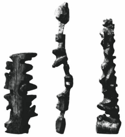 [Image: tactile maps of the Inuit: 3D representations of the Greenland coastline].
She compares these to Braille maps for the blind—which I would further compare to the embossing printer used by a blind architect in San Francisco to produce tactile building plans. “He began drawing with Wikki Stix,” the L.A. Times reported last month, “strands of wax-covered yarn that adhere to paper with just a little pressure. His most useful tool became a large-format embossing printer, which turns blueprints into raised line drawings that he can read with his fingertips.”
As if using the Inuit maps pictured above, he simply runs his fingers along the creased lines of rooms and hallways, and buildings take shape in their every variation around him.
Briefly diverging here, I was fascinated to read elsewhere in that same article about the subtle architectural design cues that can be deployed for the blind or visually impaired. For instance, the architect once “collaborated on a room-numbering system to help blind students navigate the building. The facility will use different textured flooring in a few key areas so students can tell where they are by the tap of a cane.” Further, “blind students who descend a staircase that deposits them in the middle of a vast lobby will be able to find their way because the ceiling will be enhanced, at [the architect’s] suggestion, to create an acoustic corridor to the door.” Designing “acoustic corridors” across the city sounds like a superb design challenge (as well as something that could be of much wider use in the event of prolonged urban blackouts).
In any case, like Middle Savagery, I am fascinated by the other applications these sorts of handheld, tactile maps might have—where else they might be useful and what other spaces they might be able to represent. Could there be a tactile map of a novel’s plotline, or or the New York City subway system, or of the Appalachian Trail? What about of your own apartment, or the house you grew up in? Could there be tactile cinema? Could you make a tactile map of a song?
(Spotted via an old post on Tightgrid).
I worked in a hospital doing mural work for a while and the amount of braille signage amazed me. They are required to have a braille equivalent of every sign in the hospital. This sounds great for the blind until you realize that A. I've never seen a blind person groping along a wall looking for a sign and B. some of the signs were in places that were unreachable. It's as if they passed a law to benefit the blind with no input from them.
Was looking through your site to see if you had posted anything about Haiti in the past month. Apparently not (unless I've missed it), which is sort of surprising, given your long-standing interest in earthquakes, disasters, ruins, destruction of architecture, etc.
Wondering if this is out of an unwillingness to exploit the situation, a feeling that there's not much to say about what happened there (within the scope of this blog), or some other reason.
Truly intriguing..! A few projects exploring similar interests in the role touch or tactility plays in the context of our built environment, in this instance conceived in through some of the Additive Manufacturing (Rapid Prototyping) processes, can be found at the included links below:
http://smarchitecture.blogspot.com/2009/04/project-recap-no-4-snakeskin-tactile.html
http://smarchitecture.blogspot.com/2009/04/project-recap-no-5-finger-run-tactile.html
http://smarchitecture.blogspot.com/2009/05/finger-run-update-scales-of-touch.html
and even…
http://smarchitecture.blogspot.com/2009/08/project-recap-no-6-materix-material.html
Best regards,
Tom
Thanks, Thomas – some very interesting projects there.
Secretary, sorry for the late reply to your question, but I would say that, yes, it's definitely "an unwillingness to exploit the situation, [and] a feeling that there's not much to say about what happened there (within the scope of this blog)." That final parenthetical statement is definitely key to the latter statement.
Writing an obligatory Haiti post seems more offensive to me than not writing anything about it at all; the idea that a post here on BLDGBLOG could really "do something" to galvanize people or spread awareness seems incredibly naive to me as well as wildly inaccurate in terms of scale.
It's not lack of empathy, in other words, but a sense that pretending toward the status of public mourner, anguished by feelings of solidarity with Haiti, after having never once written about issues of social justice, economic inequality, or U.S. political interference in that country, would be vampiric and morally offensive at best.
I'm throughly intrigued by the 3D maps of the Inuit. I have an abiding long-term interest in the people, geography and history of human exploration of the polar regions and had read in Barry Lopez's "Arctic Dreams" about the Northern Canadian Inuits' skill in drawing detailed maps from memory for early explorers and how accurate they were. Early European explorers maps created from ship borne observations were vague to say the least about the actual coast and for good reason. If you were on a European explorer's ship and were close enough to see the shore itself you were in all likelihood in grave peril. Not so for the skin-boat and dog-sled people who actually travelled the shore and pulled up onto it to gather the resources and reside when conditions did not permit travel. The skin-boat and dog-sled people are unique among pre-civilized hunter/gatherers for their unparalleled ability to travel really large distances in what would seem to the more advanced rest of the world were impossible conditions, and thriving with a relatively complex and material rich lifestyle and culture.
These 3D 'maps' are very interesting and I'm wondering if they show up in other inuit/aleut and coastal people of the arctic for whom northern Europe, Asia and North America was all just one big shoreline along which they were so successful for so long.