Urban coats of arms

How do you represent a city?


What decisions would you make – graphically, textually, even musically – in order to produce something sufficiently emblematic of an urban experience, something people all over the world could recognize and relate to?


[Image: Need a hint? Think Oprah].

If you had to represent New York, for instance – or London, or Shanghai, or New Orleans – or Atlantis, for that matter – what, first of all, does such a question even mean? How do you “represent” “Shanghai”?
“You.”
Well, let’s just say that we’ve answered those questions: what, then, would you choose? The people? The landscape? The skyline?
The architecture?

A series of digital city guides, produced by The Economist, uses unique graphic emblems to represent each city under discussion – in the process, making clear artistic decisions about what does or does not constitute “London” or “Sydney” or “Tokyo.”
Overwhelmingly (if unsurprisingly), these graphics – like urban coats of arms for the 21st century – choose landmark architectural sites and streetscapes for their centerpiece.
From the obvious –


– to the slightly less obvious –


(why obscure Berlin’s TV tower in clouds? why not include the Reichstag? and is that really the best Brandenburg Gate they could draw?)


(here, why hide the Golden Gate Bridge to focus on a cable car – which, as drawn, looks like every other tram on earth?)

– to the downright ugly –


(that’s Tokyo!)


(Dubai!)


(is that a UFO invading New York? why not a flaming World Trade Center?)

– to the surreal or overly abstract:


Those last two? Mexico City and Toronto.
Bilbao, Rome, Rio, Las Vegas, Montreal, Marrakech, Cairo, Baghdad – all emblemizable, so to speak: but what would those emblems depict? And what of so-called minor cities, from Glasgow to Winnipeg, Frankfurt to Xian?
What about The City of Lost Children?
What about Guantanamo Bay?
If we were to develop a new series of international coats of arms for all our global cities, what buildings or spaces or skylines – or bodies of water, or atmospheric events, or exposed geological formations, or even emblematic animals or famous disasters – earthquakes, fires, floods, terrorist attacks, atom bombs – would be included?
How do you represent a city?

Nova Arctica

it is a false and feverous state for the Centre to live in the Circumference
(Coleridge)

[Image: “The first map dedicated to the North Pole, by the great Gerard Mercator,” titled Septentrionalium Terrarum descriptio, reprinted 1623].

The North Pole’s melting ice cap is apparently creating something of an Arctic real estate boom.

Or a shipping route boom, more specifically: new Arctic sea channels are opening up almost literally every season, and new – or revived – ports are being opened – or renovated – to serve them.

Pat Broe, for instance, “a Denver entrepreneur,” bought a “derelict Hudson Bay port from the Canadian government in 1997” – for $7. That $7 port, however, could eventually “bring in as much as $100 million a year as a port on Arctic shipping lanes [made] shorter by thousands of miles” due to thawing sea ice.

Such Arctic routes are predicted to grow in importance quite rapidly “as the retreat of ice in the region clears the way for a longer shipping season.”


But the world is full of Pat Broes. Accordingly, “the Arctic is undergoing nothing less than a great rush for virgin territory and natural resources worth hundreds of billions of dollars. Even before the polar ice began shrinking more each summer, countries were pushing into the frigid Barents Sea, lured by undersea oil and gas fields and emboldened by advances in technology. But now, as thinning ice stands to simplify construction of drilling rigs, exploration is likely to move even farther north.”

Aside from the inevitable and ecologically unfortunate discovery of new Arctic oil reserves (“it’s the next energy frontier,” a Russian energy worker says), the “polar thaw is also starting to unlock other treasures… perhaps even the storied Northwest Passage.”

[Image: A 1754 De Fonte Map of the Northwest Passage].

Something of a land grab – or sea grab – is now underway: “Under a treaty called the United Nations Convention on the Law of the Sea, territory is determined by how far a nation’s continental shelf extends” offshore – adding a somewhat Freudian dimension to Arctic real estate. (Or perhaps we could call it the Arctic Real, where “the true coordinates are much better hidden than we realize.”)

In any case: “Under the treaty, countries have limited time after ratifying it to map the sea floor and make claims.” What kind of claims? “[C]laims of expanded territory.”

But it soon gets interesting. “In a 2002 report for the Navy on climate change and the Arctic Ocean, the Arctic Research Commission, a panel appointed by the president, concluded that species were moving north through the Bering Strait.” [Emphasis added]. Territorial alterations and geographic changes at the pole, in other words, are leading to unexpected seaborne migrations, repositionings of the planetary gene pool.

Surely there’s a James Cameron film in there, or at least some kind of Arctic pulp fiction thriller dying to be written?

In any case, as new territories, both aquatic and terrestrial, appear at the Earth’s poles, we might do well to reconsider what Victoria Nelson calls “the Polar gothic,” or “the literary genre of mystical geography,” part of a “psychotopography” of the Earth…

Either way I want to mention – as Nelson does – a text by H.P. Lovecraft. In his slightly goofy 1931 novella, At the Mountains of Madness, Lovecraft sends a group of geologists to the south pole where they’re meant to collect “deep-level specimens of rock and soil from the antarctic continent.” Under “great barren peaks of mystery” and “desolate summits” made of “Jurassic and Comanchian sandstones and Permian and Triassic schists, with now and then a glossy black outcropping suggesting a hard and slaty coal,” they go snowshoeing, dogsledding, and hiking some more – till, drilling through ice into the ancient metamorphic prehistory of a once-tropical antarctic mountain range, they begin “to discern new topographical features in areas unreached by previous explorers.”

Soon they find weird marine fossils.

Then ancient, apparently manmade artifacts turn up.

At night they hear things.

Then they find a city.


This antarctic city is “of no architecture known to man or to human imagination, with vast aggregations of night-black masonry embodying monstrous perversions of geometrical laws. (…) All of these febrile structures seemed knit together by tubular bridges crossing one to the other at dizzying heights,” including “various nightmare turrets,” crowding “the most utterly unknown stretches of the aeon-dead continent.” Etc.

Lovecraft’s polar gothic now continues apace, however, at the opposite end of the Earth, as the planet’s northernmost currents of melting ice bring new rivers, new migrations, and even new instant cities deep into the waters of thawing Arctic archipelagos.

Landscapes of “a world gone wrong”


[Image: Flood].

Artist-photographer Lori Nix creates miniature landscapes “out of any material that will simulate a real landscape; for example faux fur becomes field grass, buckwheat flour becomes dirt.”
She then photographs these sets, producing evidence of “a world gone wrong.”


[Image: Blimp].

These disasters, camouflaged within idyllic surroundings – Nix’s series is entitled “Accidentally Kansas” – are not even immediately noticeable –


[Image: Ice Storm, 1999].

– until they’re all but impossible to ignore.


[Image: Plane].

While resembling the work – or at least the working methods – of Oliver Boberg and Thomas Demand, there is something much more readily pronounced in almost all of Nix’s photographs: a sense of humor.


[Image: Parade, 2004].

My immediate response here is: 1) you have to build more of these things, they’re crazy, you could have skyscraper infernos and earthquakes leveling Los Angeles and pitch-black space shuttles hurtling past the moon and…; but then I calm down and think: 2) how about some avian flu?
28 Days Later meets an illegal container ship full of infected chickens and people on the streets of London go toppling over like dominos, bodies in heaps in Piccadilly Circus, the King’s Road lined with cadavers…
Lori Nix takes the photograph and: simulation precedes reality.

(Lori Nix discovered via the very, very excellent things magazine).

Architectural averages

The series Go Ogle by photographer Meggan Gould takes the first 100 responses to a Google image search, then overlays those 100 images into a single photographic “average.”


[Image: leaning+tower+pisa].

As Gould herself writes:
“The results, a visualization of intersections between Boolean logic and the popular imagination, are more often than not a hopeless jumble of unidentifiable pixels – but occasionally a recognizable form does emerge.” See animation.
“Word choice, spelling, and textual hints are all critical to conducting an effective search, and the averages reflect their importance: a search for coke+can reveals a crisp, almost legible average, whereas coca+cola+can is muddy and barely recognizable. Truly iconic imagery is elusive, particularly considering the glut of computer graphics through which internet spiders and archivers crawl daily; only a small fraction of searches retains any degree of legibility through the averaging process.”
But some of the most recognizable averages, I have found, are architectural.


[Image: tower+babel].


[Image: pyramid+giza].

Leaving me to wonder what has to be at least one other BLDGBLOG reader’s first thought: what about world+trade+center?
september+11th?
If BLDGBLOG was richer, in fact, it could probably keep Meggan Gould in business for several years, producing more and more – and more and more – architectural averages: stone+henge; san+andreas+fault; berlin+wall; yucca+mountain; space+shuttle; taj+mahal; falling+water

PS: big+ben; forbidden+city; chrysler+building; trump+tower

Death’s pyramids and Boullée’s domes

While BLDGBLOG just explored Etienne-Louis Boullée’s Cenotaph for Newton – of which some better images appear here –


– complete with an internal view of the dome’s constellational ceiling –


– Boullée also designed another, if substantially less well-known, cenotaph (complete, again, with monumentally over-sized dome and somewhat ridiculous, almost elephantiasis-stricken, pyramidal shell), revealed here in both elevation and section –


– as well as yet another tomb – or cénotaphe – here a kind of architectural remix of the first pyramid:


And even that wasn’t the end. Boullée designed a tomb for Hercules; a tomb for Sparta; several funerary monuments; and a chapel of the dead that seems to have set the architectural temperature for the bunker-like, uninspired, and potentially even anti-Christian churches you now find all over today’s middle America:


Well, actually, it looks an awful lot like the house Robert Venturi built for his mother –


– which I suppose says something about Robert Venturi.

Sections, Tombs, and Stock Exchanges

Several years ago, a friend of mine gave me a small exhibition guide to “The Amsterdam Stock Exchange: A Structure Revealed,” by Daniel Castor.
After winning a Fulbright in 1992, Castor “created twenty-two drawings [of the Amsterdam Stock Exchange] that, like x-ray photographs, enable us to look through the building’s walls into its inner spaces in a way that one could neither achieve by means of photography nor by viewing the building in person.”


The drawings are “magnificently beautiful,” the Getty’s guide opines. By “gradually peeling away more and more of the exterior wall, like an archaeologist digging through centuries of rubble… Castor shows that the facade is no more than a thin layer around a circulatory space circumscribing the main exchange halls.”
Castor also produced a series of sketches of Bramante’s Tempietto –


– of which these are two.
But then today I stumbled across a new post on Pruned, about Jean-Jacques Lequeu, architect, cross-dresser, amateur pornographer: “In post-Revolution and Napoleon France,” Pruned writes, “Lequeu produced some of the most imaginary landscape and architectural designs” of his time, using “a masterful combination of the Gothic, the Egyptian, the Greek, the Chinese, and a smattering of hallucinations.” And, however superficially, Lequeu’s drawings reminded me of Castor’s work:


[Image: Elévation géométrale for Laqueu’s Temple consacré à l’Egalité].

Then there is the quite similar, but really, really, really exciting Temple de la Terre:


If you enlarge the image, you’ll see that the building’s dome is actually a detailed globe of the earth, and that its surface is pierced by dozens of small holes; these allow light to burn through, into the interior, in the shape of constellations. Which, of course, makes it rather a lot like Boullée’s Cenotaph for Newton


– but, in many ways, Lequeu’s design is more interesting (if only because its less monolithic, less death-obsessed scale makes it a legitimate ancestor for today’s planetaria).


In any case, there are so many cool images – out of 784, total – on the Jean-Jacques Lequeu website that it’s tempting to sit here uploading more and more of the things; but I’ll stop.
Meanwhile, slicing buildings into sections, letting patterned light through, and using architecture to help model the constellations, will all be picked up again elsewhere…

A Drive-Thru Enemy Landscape

In a short article published by the Center for Land Use Interpretation, we read about “a rare example of a simulated hostile nation on American soil, open to the public.”
This “drive-thru enemy landscape” is in the Dixie Valley of Nevada.


[Image: Center for Land Use Interpretation; note the tank].
After a long series of complicated land deals, the U.S. Navy “began burning down the homesteads it bought, replacing them with Soviet radar and military equipment to simulate an enemy landscape.”
Because the Valley is still open to “transit by the public,” it currently serves as a kind of “open air gallery of active warfare props,” complete with a few old homestead buildings “left to be used as visual targets, mak[ing] for a mise en scene that resembles the surrealist renderings of Dalí and de Chirico”:


But while Dixie Valley may be “a rare example” of such a landscape, it is not unique: there is also the so-called German Village in Utah’s Dugway Proving Ground.


[Image: The remnants of German Village in 1998, taken by CLUI/Mike Davis].
As Mike Davis writes, “‘German Village,’ as it is officially labeled on declassified maps of the US Army’s Dugway Proving Ground, is the remnant of a much larger, composite German/Japanese ‘doomtown’ constructed by Standard Oil in 1943.” That same year, “the Chemical Warfare Corps secretly recruited [architect Erich] Mendelsohn to work with Standard Oil engineers and RKO set designers to create a miniature Hohenzollern slum in the Utah desert.”
Hollywood + European Modernism = Enemy Faux-Urbanism.
“Dugway, it should be pointed out,” Davis says, “is slightly bigger than Rhode Island and more toxically contaminated than the Nuclear Test Site in nearby Nevada.”
In any case, German Village was built to be destroyed, as its exact and to-scale replicas of Berlin architecture – down to precise materials – could be tested for flammability. How architecture reacts to bombs.
German Village, in other words, was another “simulated hostile nation on American soil.”

(Of related interest, see BLDGBLOG’s A miniature city waiting for attack and Law enforcement training architecture).

Bingham Pit, Utah

“It is 2.5 miles wide and 3/4 mile deep. Looking into it is like looking into space,” the Center for Land Use Interpretation suggests. It’s Utah’s Bingham Canyon Copper Mine, and it just might be “the biggest hole on earth.”

[Image 1: CLUI; Image 2: here; Image 3: here].

Also, see Placement‘s One Hundred Years Towards Hell; as well as BLDGBLOG’s World’s largest diamond mine.

Earth: 7.5 Billion AD

Don’t forget “the distant future,” an article in New Scientist warns, referring to an era 7.5 billion years from now – when “the sun will loom 250 times larger in the sky than it is today, and it will scorch the Earth beyond recognition.”

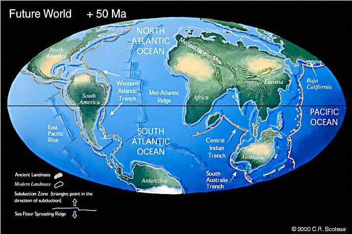
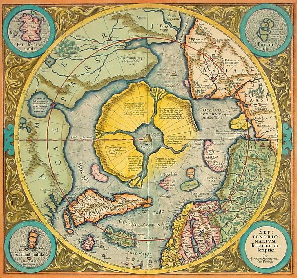
That Earth, however, will be unrecognizable, geologically reconfigured into something called Pangaea Ultima: “Existing [subduction] zones on the western edge of the Atlantic ocean should seed a giant north-south rift that swallows heavy, old oceanic crust. The Atlantic will start to shrink, sending the Americas crashing back into the merged Euro-African continent. So roughly 250 million years from now, most of the world’s land mass will once again be joined together in a new supercontinent that [Christopher] Scotese and his colleagues [at U-Texas, Arlington] have dubbed Pangaea Ultima.”

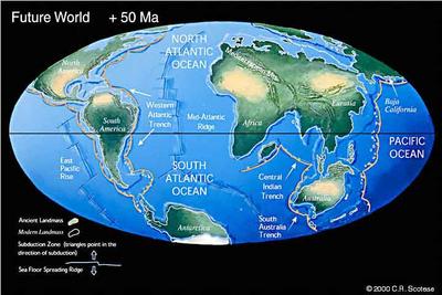
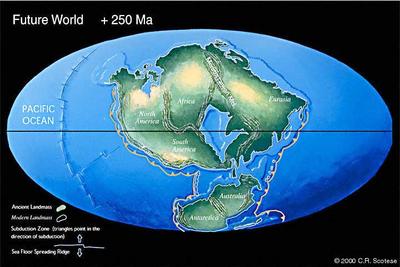
[Images: Pangaea Ultima, or the Earth in 250 million years, from Christopher Scotese’s website. It’s interesting here to imagine where the cities of today might end up in this configuration, if Manhattan will collide, say, with the docklands of London, and what that new city would then be called – and could you set a novel in a space like that? You look out and see Manhattan coming toward you on the horizon, at the speed of a fingernail growing, and you take little rowboats out to visit it on long summer afternoons, that ghost city adrift on mantled currents of earthquake-laden rock. Or would it be possible for an architect – or two architects, on opposite sides of the ocean – to design, today, different buildings meant to merge in millions of years, to collide with each other and link into one building through plate tectonics, a kind of delayed, virtual, urban self-completion via continental drift… Cairo-Athens: an architectural puzzle assembled by the Earth’s own geological mechanisms].

After Pangaea Ultima, runaway greenhouse warming and a literally expanding sun will mean that everything “gets worse. In 1.2 billion years, the sun will be about 15 per cent brighter than it is today. The surface temperature on Earth will reach between 60 and 70°C and the… oceans will all but disappear, leaving vast dry salt flats, and the cogs and gears of Earth’s shifting continents will grind to a halt. Complex animal life will almost certainly have died out.”

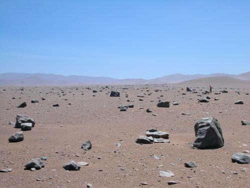
Jeffrey Kargel, from the U.S. Geological Survey’s office in Flagstaff, Arizona, offers his own vision of planetwide erosion: “‘Imagine a steaming Mississippi river delta with 90 per cent of the water gone. There’ll be lots of sluggish streams and the whole Earth will be flattening out. All the mountains will be eroded down to their roots.’ Huge swathes of the Earth might resemble today’s deserts in Nevada and southern Arizona, with low, rugged mountains almost buried in their own rubble.”

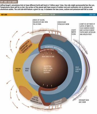
Kargel believes that the Earth might even become “‘tidally locked’ to the sun. In other words, one side of the planet will be in permanent daylight while the other side will always be dark.”

The side of the planet always in the glare of triumphant Apollo will eventually consist of huge roiling seas of liquid rock – perhaps ready for the return of Coleridge’s Ancient Mariner. “7.57 billion years from now, the magma ocean directly in the glare of the sun will reach almost 2200°C. ‘At that kind of temperature, the magma will start to evaporate,’ (!) says Kargel.”

Meanwhile, “Kargel thinks the night side of the Earth could be… about -240°C. And this bizarre hot-and-cold Earth will set up some exotic weather patterns.”

[Image: “Exotic” future weather systems (from New Scientist); worth enlarging. We could thus anticipate a market in weather futures: the financial coupling of climatology and the global reinsurance industry, but, here, gone deep time and virtual].

“On the hot side, metals like silicon, magnesium and iron, and their oxides, will evaporate out of the magma sea. In the warm twilight zones, they’ll condense back down. ‘You’ll see iron rain, maybe silicon monoxide snow,’ says Kargel. Meanwhile potassium and sodium snow will fall from colder dusky skies.”

So it would seem possible, amidst all this, to figure out, for instance, the melting point of Manhattan, ie. the point at which rivers of liquid architecture will start flowing down from the terraces of uninhabited high-rise flats, when the top of the Chrysler Building, all but invisible behind superheated orange clouds of toxic greenhouse gases, will form a glistening silver stream of pure metal boiling down into the half-closed Atlantic Ocean.

If cities are viewed, in this instance, as geological deposits, then surely there would be a way to account for them in the equations of future geophysicists: all of London reduced to a pool of molten steel, swept by currents of gelatinous glass, as sedimentary rocks made of abraded marble, granite, and limestone form from compression in the lower depths. A new Thames of liquid windows, former walls.

Any account of a future Earth, in other words, melting under the glare of a red giant sun, should include the future of cities, where buildings become rivers and subways will fossilize.

All cities, we could say, are geology waiting to happen.

(See BLDGBLOG’s Urban fossil value for more).
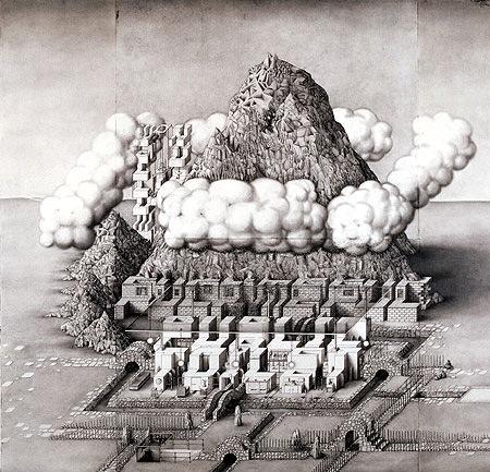
Nobson Newtown

I just found an old article from frieze about graphic artist Paul Noble‘s “monumental eight-year project… [to create] a fictional city called Nobson Newtown.”


Nobson Newtown was an “exercise in self-portraiture via town planning,” involving “the painstaking design of a special font based on the forms of classic modernist architecture.”
The “city,” in other words, was made of words.


“Variously described as ‘3-D Scrabble tiles’ or ‘Lego blocks’, Noble’s pictograms name the buildings that they depict. From the hospital (Nobspital) to the cemetery (Nobsend) via the town centre (Nobson Central) or the Mall, citations from Omar Khayyam’s Rubaiyat, Gerard Winstanley’s letters to Oliver Cromwell or T.S. Eliot’s The Wasteland are camouflaged within the fields, the trees or the brickwork. Noble’s project embodies a complex infrastructure of civil planning, social policies and historical perspectives” – and it was all done with pencil. (Book available here).


“At first,” says the BBC, “the drawings appear to be depictions of a crazy Babylonian society, with a touch of Brueghel’s Tower Of Babel and Robert Crumb’s rounded comic strips. Then you realise each building is also a 3-D letter of the alphabet spelling out hard to decipher sentences in Noble’s self-created Nobfont.”


But he wasn’t the first.
Nearly two decades earlier, in 1980, Steven Holl published his own “Alphabetical City” through Pamphlet Architecture, and it, too, consisted entirely of buildings that were actually letters, that were actually a city, that… – but the funny thing is, Holl’s drawings look absolutely, unpublishably stupid compared to Noble’s:


Hello? One wonders which two-minute lunch break Holl took to draw those… Or was it thirty seconds?
In any case, the creation of architectural space through a tweaking of the alphabet is not an inherently interesting proposition, but Noble’s eye-failure-inducing drawings reward repeated viewings. Just blink occasionally.
The buildings, frieze‘s Tom Morton claims, look like, “odd, wind-carved rock formations. Standing on higher ground, squinting against the sun, we’d see that they formed an eroded text.”
Here I’m reminded of the idea of “slow sculpture” from China Miéville’s novel, Iron Council:
“Huge sedimentary stones… each carefully prepared: shafts drilled precisely, caustic agents dripped in, for a slight and so-slow dissolution of rock in exact planes, so that over years of weathering, slabs would fall in layers, coming off with the rain, and at very last disclosing their long-planned shapes. Slow-sculptors never disclosed what they had prepared, and their art revealed itself only long after their deaths.”
Perhaps, in those dissolving rocks, you could plan a slow and secret alphabet…